A Zurich tourist map makes more sense once you see the city as a lake at the bottom, a river running up from it, and an Old Town on both banks with the main station at the top. I put the bus tour stops and the top 20 attractions, ranked by Google reviews, on one page, with coordinates and a Google Maps link for each. For the tickets that ride the routes, see my guide to hop-on hop-off Zurich.
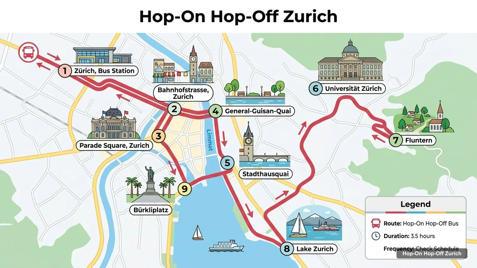
The route image follows the stop order on the Gray Line listing, the only Zurich listing with a full ordered itinerary. The tables are generated from my place data, so the coordinates match what Google Maps shows. Checked October 2026.
Zurich Sightseeing Map: The Bus Route
The Zurich sightseeing map below shows the Gray Line city bus tour, numbered from the bus station behind the main station. The route runs along Bahnhofstrasse to Paradeplatz, the lake quays, the university quarter and Fluntern, then returns to Bürkliplatz for the 90-minute lake cruise. The listing marks Stadthausquai as a 10-minute photo stop and the other stops as pass-by sights.
Stops on the route
1Zürich, Bus Station
2Bahnhofstrasse, Zurich
3Parade Square, Zurich
4General-Guisan-Quai
5Stadthausquai
6Universität Zürich
7Fluntern
8Lake Zurich
9Bürkliplatz
Bus tour stops
The table lists the boarding point and the stops in the listing’s order. The listing gives the boarding address as Ausstellungsstrasse 5 and says to enter Limmatstrasse 4 in GPS. Note that these are tour stops where the bus passes or stops briefly, not hop-on hop-off stops. The listing says the route may change for construction or public events.
The other two city tickets have their own routes. The open-top bus lists the Swiss National Museum, Paradeplatz, the Rietberg Museum, Belvoir Park, the Rotes Schloss, the Fraumünster, the lake and Bahnhofstrasse. The guided tour adds Münsterhof, the Zürichberg viewpoint and an optional FIFA Museum drop-off. The Interlaken bus is separate: Zurich, Lucerne, Interlaken, Grindelwald and Lauterbrunnen.
Zurich Attractions: Top 20 by Reviews
The Zurich attractions below are ranked by Google review count, with coordinates and the distance from Zurich HB in a straight line. I removed tour operators, the bus station and a few small fountains with a handful of reviews. Rhine Falls tops the list but sits about 34 km away, so read the distance column before you plan a day around it.
The latitude and longitude columns are the Google Maps coordinates of each place, and you can paste them into any map app. The distance column is measured from the Zürich Visitor Information point inside the main station, which is a fair proxy for Zurich HB. Real walking routes are longer, because the Limmat and the lake force detours, so add roughly a quarter to any short distance.
Three rules of thumb help with this Zurich tourist map. Anything under 1 km is a walk. Anything from 1 to 3 km is a tram ride or a long walk, such as the FIFA Museum at 1.8 km or the Zoo at 2.6 km. Anything over 4 km, such as the Uetliberg at 4.9 km, is a half-day outing, and Rhine Falls at 33.8 km is a full day.
Opening days matter as much as distance. Google shows the Swiss National Museum, the Kunsthaus, the FIFA Museum and the Museum Rietberg closed on Mondays, while Lindenhof, Zürichhorn and the Uetliberg are listed as open 24 hours. If your only free day is a Monday, build the route around the churches, squares and the lake.
Is Zurich Worth Visiting
Is Zurich worth visiting? I think yes for a short stay. Lindenhof has 13,472 Google reviews at 4.7, the Swiss National Museum 10,250 at 4.6, and the lake and the Alps are close. The tourism region recorded 7.56 million overnight stays in 2025, up 3.5 percent, according to regional tourism results, so you will not be alone.
The caveat is that the sights are modest in size. If you want one famous monument, Rhine Falls is the closest and most reviewed, and it is not in the city. If you like walkable old towns, churches and museums, Zurich rewards a long weekend. My Zurich itinerary shows how I would pace it.
What Is Zurich Known For
What Zurich is known for, at least in my data, is its Old Town churches, its lakeside and its museums. Grossmünster has 10,305 reviews at 4.5, the Kunsthaus 9,451 at 4.7 and the FIFA Museum 7,351 at 4.4. One listing I checked describes the city as a world centre of the banking sector, and the Gray Line route passes Bahnhofstrasse and Paradeplatz for that reason.
I would not build a trip around a food claim, because I have no restaurant data. What the data does support is a city of hills, water and compact squares. The guided tour mentions the university quarter and ties it to Albert Einstein.
Zurich Tourist Attractions: Clusters
The Zurich tourist attractions fall into four clusters, which is the easiest way to read the map.
Station and Old Town. The Swiss National Museum, Lindenhof, Grossmünster, Fraumünster, St. Peter and Paradeplatz are all within about 0.9 km of Zurich HB. This is the walking core.
Lake and Enge. The FIFA Museum is about 1.8 km from the station and the Museum Rietberg 2.3 km. The lake cruise leaves from Bürkliplatz.
East shore. Zürichhorn is about 2.8 km away and the Botanical Garden 2.7 km. Pavillon Le Corbusier is 2.5 km out.
Hills. The Zoo is 2.6 km from the station, the Uetliberg 4.9 km and the Loorenkopf 4.5 km.
Pick one cluster per half day. The bus tours stay in the first two clusters, plus Fluntern on the Gray Line route, and do not cover the east shore or the hills.
Zurich Tourist Information
Zurich tourist information is easiest to get at the Zürich Visitor Information desk in the main station, rated 4.7 from 909 reviews on Google. Google shows it open 8:30 AM to 7 PM Monday to Saturday and 9 AM to 6 PM on Sunday, and the website is zuerich.com.
For transport, the official ZVV site lists a check-in day pass for the city zone at CHF 8.50 for an adult in second class. I could not confirm single-ticket prices, so use the app. For tours, the Gray Line meeting point is the Sihlquai bus station, and its listing says to use Limmatstrasse 4 in GPS. Arrive early with your voucher.
Using This Map
Open the table on your phone, tap a map link, and walk. My rule is to keep every walking leg under 1 km in the Old Town and take a tram for anything over 2 km. The best things to do in Zurich page ranks the sights, and the homepage lists every city I cover. For the tickets, go back to my page on Zurich bus tours compared.
Frequently asked questions
Is there a printable Zurich tourist map?+
This page works as one. The route image shows the Gray Line city tour with numbered stops, and the tables list those stops and the top 20 attractions with coordinates and map links. For a printed map, ask at the Zürich Visitor Information desk in the main station, which Google lists as open daily.
Where are most Zurich attractions on the map?+
Around the Limmat in the Old Town, within about 1 km of the main station. Lindenhof, Grossmünster, Fraumünster, Paradeplatz and the Swiss National Museum all fall inside that radius. The Zoo, the Botanical Garden and the Uetliberg are 2.6 to 4.9 km out.
How far apart are the main Zurich sights?+
Close in the centre. The Swiss National Museum is about 0.2 km from Zurich HB, Lindenhof 0.5 km, Grossmünster 0.9 km and the Kunsthaus 1.0 km in a straight line. Only the Zoo (2.6 km), the Uetliberg (4.9 km) and Rhine Falls (33.8 km) need transport.
What is Zurich known for?+
In my place data, Rhine Falls, the Zoo, Lindenhof, Grossmünster and the Swiss National Museum draw the most Google reviews. The city is also known for its lake and the nearby Alps. A listing I checked describes it as a world centre of the banking sector.
Tours I compared in Zurich
My full review of each one, in the order I rank them: