Vancouver Tourist Map: Top Attractions & Bus Stops
By Jake Dawson · Updated · Affiliate links, explained in my disclosure
Happy Hour
Vancouver: Hop-On Hop-Off City Tour, Small Group "12 Stops"
4.9 (605) · from $49.15
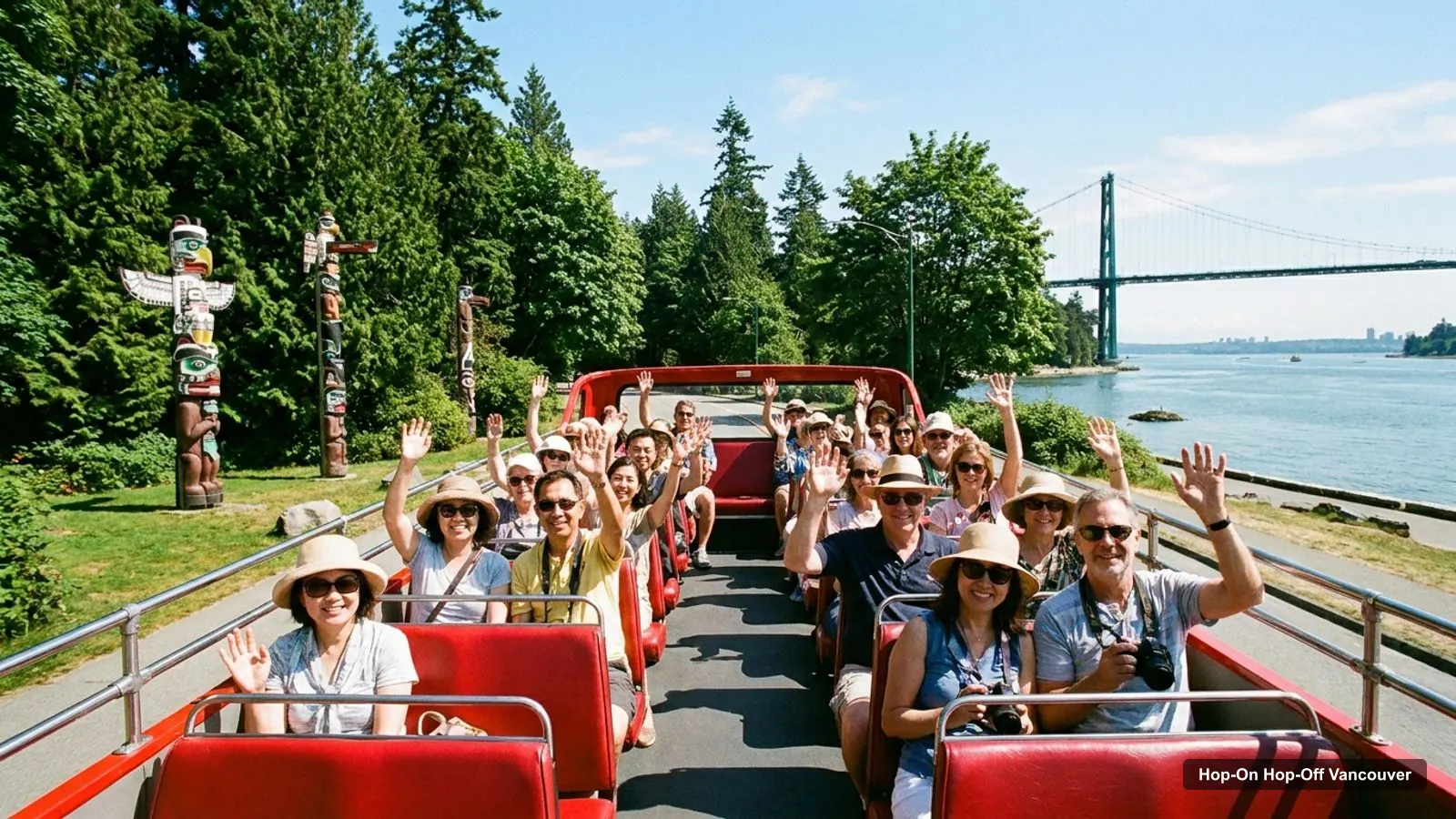
This Vancouver tourist map puts the bus stops, the top attractions and their coordinates on one page. It’s the companion to my hop-on hop-off Vancouver comparison, where I compare the five tours with prices from $41.53. Every stop name comes from the route listings, and every coordinate comes from Google Maps place data. I haven’t walked the routes, so use the distances as a planning guide.
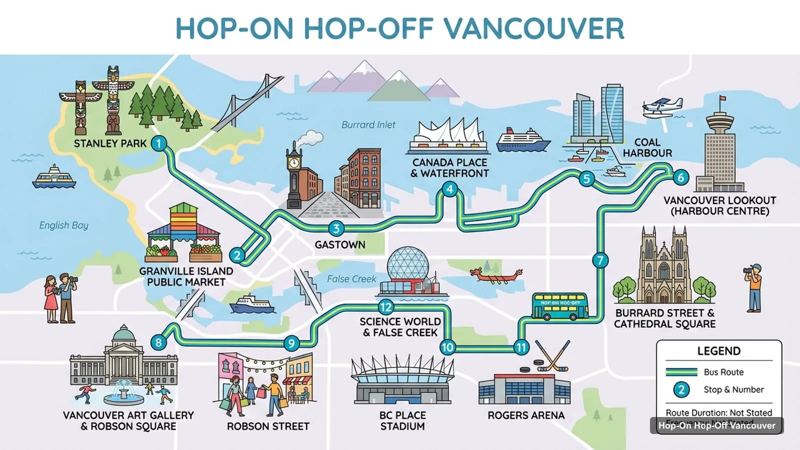
Stops on the route
- 1Stanley Park
- 2Granville Island Public Market
- 3Gastown
- 4Canada Place & Waterfront
- 5Coal Harbour
- 6Vancouver Lookout (Harbour Centre)
- 7Burrard Street & Cathedral Square
- 8Vancouver Art Gallery & Robson Square
- 9Robson Street
- 10BC Place Stadium
- 11Rogers Arena
- 12Science World & False Creek
Vancouver Tour Map: The 12 Hop-On Hop-Off Stops
The route graphic above follows the 12-stop order listed by the Happy Hour small-group van, rated 4.89 from 605 reviews. Horizon Touring’s van also runs 12 stops, from 8:00 AM to 8:00 PM daily. Each stop name below links to Google Maps, so you can save the ones you plan to use.
| # | Stop | Map |
|---|---|---|
| 1 | Stanley Park | Find on Google Maps |
| 2 | Granville Island Public Market | Find on Google Maps |
| 3 | Gastown | Find on Google Maps |
| 4 | Canada Place & Waterfront | Find on Google Maps |
| 5 | Coal Harbour | Find on Google Maps |
| 6 | Vancouver Lookout (Harbour Centre) | Find on Google Maps |
| 7 | Burrard Street & Cathedral Square | Find on Google Maps |
| 8 | Vancouver Art Gallery & Robson Square | Find on Google Maps |
| 9 | Robson Street | Find on Google Maps |
| 10 | BC Place Stadium | Find on Google Maps |
| 11 | Rogers Arena | Find on Google Maps |
| 12 | Science World & False Creek | Find on Google Maps |
The other operators draw their routes differently. The Gray Line trolley lists 18 stops, including six in Stanley Park, and the Westcoast double-decker lists five headline areas (Canada Place, Granville Island, Stanley Park, Gastown, Chinatown) within a 10-stop route. All of them start from Canada Place.
Vancouver Tourist Attractions Map: Top 20 Sights with Coordinates
This is the Vancouver tourist attractions map in table form, ranked by Google Maps reviews, with exact coordinates. I left out the bus operators, the Harbour Centre duplicate of the Lookout, and places over 15 km away. Each link opens the place in Google Maps, where you can save it to a list.
| # | Attraction | Coordinates | Google rating | Map |
|---|---|---|---|---|
| 1 | Stanley Park | 49.30426, -123.14425 | 4.8 (49,014) | Open in Google Maps |
| 2 | Capilano Suspension Bridge Park | 49.34286, -123.11492 | 4.6 (38,500) | Open in Google Maps |
| 3 | Gastown Steam Clock | 49.28441, -123.10887 | 4.5 (29,124) | Open in Google Maps |
| 4 | Canada Place | 49.28882, -123.11112 | 4.6 (28,328) | Open in Google Maps |
| 5 | English Bay Beach | 49.28631, -123.14349 | 4.7 (19,926) | Open in Google Maps |
| 6 | Science World | 49.27338, -123.10383 | 4.5 (16,494) | Open in Google Maps |
| 7 | Queen Elizabeth Park | 49.24176, -123.11262 | 4.7 (15,369) | Open in Google Maps |
| 8 | VanDusen Botanical Garden | 49.23957, -123.13254 | 4.7 (13,913) | Open in Google Maps |
| 9 | Vancouver Aquarium | 49.30049, -123.13088 | 4.5 (13,010) | Open in Google Maps |
| 10 | Vancouver Art Gallery | 49.28296, -123.12047 | 4.3 (9,375) | Open in Google Maps |
| 11 | Flyover | 49.28931, -123.11027 | 4.5 (8,988) | Open in Google Maps |
| 12 | Sunset Beach Park | 49.27941, -123.13807 | 4.7 (8,860) | Open in Google Maps |
| 13 | Totem Poles | 49.29925, -123.12085 | 4.5 (7,714) | Open in Google Maps |
| 14 | Museum of Anthropology at UBC | 49.26950, -123.25944 | 4.7 (6,107) | Open in Google Maps |
| 15 | Lighthouse Park (West Vancouver) | 49.33164, -123.26359 | 4.7 (5,226) | Open in Google Maps |
| 16 | Vancouver Lookout | 49.28492, -123.11223 | 4.6 (3,914) | Open in Google Maps |
| 17 | David Lam Park | 49.27233, -123.12486 | 4.6 (3,624) | Open in Google Maps |
| 18 | Vancouver Seawall | 49.29610, -123.12798 | 4.8 (3,031) | Open in Google Maps |
| 19 | Prospect Point Lookout | 49.31360, -123.14232 | 4.8 (3,013) | Open in Google Maps |
| 20 | Museum of Vancouver | 49.27628, -123.14437 | 4.3 (2,132) | Open in Google Maps |
Vancouver Tourist Guide: The Three Clusters
Read the coordinates above and you’ll see three tight groups on the Vancouver tourist guide map:
- Downtown waterfront (around 49.285, -123.11): Canada Place, FlyOver Canada, the Gastown Steam Clock and the Vancouver Lookout. Canada Place to Gastown is 0.5 km and to the Lookout 0.4 km. The Art Gallery is 0.9 km away. You can walk all of it in a morning.
- Stanley Park and the beaches (around 49.29 to 49.31, -123.12 to -123.14): Stanley Park, the Aquarium, the totem poles, Prospect Point, English Bay and Sunset Beach. Canada Place to Stanley Park is 3.0 km and to English Bay 2.4 km. This is where the bus saves you the most walking.
- The gardens to the south (around 49.24, -123.12): Queen Elizabeth Park and VanDusen, 5.2 km and 5.7 km from Canada Place and only 1.5 km apart. No hop-on hop-off listing in my data names them.
Science World sits alone at the east end of False Creek, 1.8 km from Canada Place and 1.3 km from the Steam Clock. Capilano Suspension Bridge Park is 6.0 km away across the inlet, and the Museum of Anthropology at UBC is 11.0 km west. Plan one cluster per half day. My best things to do in Vancouver guide has what to see at each, and my Vancouver itinerary shows how to split them over days.
Vancouver Tourist Information: Which Stop for Which Sight
Vancouver tourist information gets easier once you know which stop serves which sight, based on the operators’ listings:
- Canada Place and FlyOver Canada: Canada Place is the start for the Westcoast, Gray Line and Horizon Touring routes. FlyOver Canada has the same address (999 Canada Pl), but entry isn’t included in any ticket.
- Gastown Steam Clock: Gastown is listed by the Westcoast, Gray Line and Happy Hour routes. The Lookout admission tour gives it a 10-minute photo stop.
- Vancouver Lookout: the Happy Hour van lists the Vancouver Lookout (Harbour Centre) as a stop, and the Westcoast Lookout tour gives it an hour.
- Stanley Park: every route stops here. The trolley’s stops include the Pavilion and Rose Garden, Brockton Point Totem Poles, Prospect Point Lookout, the Hollow Tree, Third Beach and Second Beach.
- Granville Island: on every route, and the Lookout admission tour gives it an hour of free time.
- English Bay and Sunset Beach: the Happy Hour van lists them as one stop.
- Science World: listed by the Happy Hour van as Science World and False Creek.
- Vancouver Art Gallery: listed by the van together with Robson Square.
- Chinatown: listed by the Westcoast and Happy Hour routes.
Vancouver Tourist Information Centre and Office
I don’t have a visitor centre address in my data, so I won’t invent one. For official tourist information, I’d use Destination Vancouver, and for transit questions, TransLink. If you board a hop-on hop-off bus at Canada Place, the driver or the brochure can answer timetable questions: the Gray Line listing says its brochure includes a map and timetables. Times are subject to change, and the last Gray Line bus from Canada Place leaves at about 3:45 PM from October to April and about 4:00 PM from mid-April to October.
Vancouver Route Maps by Operator
Each sightseeing operator draws its own Vancouver route map, and they differ more than the brochures suggest. The Happy Hour small-group van lists 17 places in total, with a 12-stop headline loop that runs from Stanley Park through Granville Island Public Market, Gastown, Canada Place and Coal Harbour to the Vancouver Lookout, Burrard Street, the Art Gallery, Robson Street, BC Place, Rogers Arena and Science World. Beyond those 12 it names the Cambie Bridge Viewpoint, the Burrard Bridge and Vancouver House, English Bay and Sunset Beach, Chinatown, and the Marine Building with the Olympic Village.
The Gray Line trolley is the most detailed on Stanley Park: the Pavilion and Rose Garden, Brockton Point Totem Poles, Prospect Point Lookout, the Hollow Tree, the Tea House at Third Beach, Second Beach and Stanley Park Brewing. Downtown it adds Robson Street, the shopping district, the West End, the entrance to Davie Village, Granville Island, the entertainment district, Library Square, the sports district and Gastown. The listing describes 19 stops in the downtown area. The Westcoast double-decker passes Waterfront Station, the Sun Tower, the Vancouver Public Library, Yaletown and the West End, and the Westcoast Lookout tour is a fixed route rather than a hop-on hop-off loop.
Reading the Coordinates
The coordinates in the top-20 table are latitude then longitude, so a difference of 0.01 in latitude is roughly 1.1 km north to south. That’s how I got the cluster distances above: for example, Queen Elizabeth Park (49.24176) and VanDusen (49.23957) are about 1.5 km apart, while Canada Place (49.28882) and Stanley Park (49.30426) are 3.0 km apart. Use the Google Maps links in the table when you want walking times, since my figures are straight lines and the real route around Coal Harbour and the Seawall is longer.
Printable Vancouver Tour Map and Walking Tips
If you want a printable Vancouver tour map, print this page: the route image and two tables fit on a few sheets and keep the stop numbers next to the sights. A few walking tips from the coordinates: the downtown waterfront cluster is walkable in a morning, but the long hop from Stanley Park to the gardens in the south is not, so ride between clusters and walk within them. For the cheapest ticket that links them, my pick is the Horizon Touring van at $41.53, and for the best rating the Happy Hour van at 4.89. You can compare all five on my Vancouver hop-on hop-off tours page, and the home page, Tours Hop-On Hop-Off, lists my other cities.
Frequently asked questions
Where is the Vancouver tourist information centre?
My data doesn't list a visitor centre address, and I won't guess one. Destination Vancouver, the city's tourism board, publishes current visitor information online. For bus questions, the Westcoast Sightseeing, Gray Line and Horizon Touring listings each give a Canada Place start, so Canada Place on the waterfront is where I'd go to board and ask.
Is there a free tourist map of Vancouver?
This page is one: the route image, the stop table and the top-20 attractions table with Google Maps links all fit on a few printed sheets. The Gray Line trolley pass also includes a brochure with a map and timetables, according to its listing, and the Happy Hour tour includes a city map and route information.
How many hop-on hop-off stops are there in Vancouver?
It depends on the operator. The Happy Hour small-group van lists 12 stops in its title and 17 places in total, the Gray Line trolley lists 18 stops and says 19 in its description, and the Westcoast double-decker quotes 10. The Horizon Touring van runs 12 stops. The table on this page uses the 12-stop van order.
What are the main areas for tourists in Vancouver?
From the coordinates in my data, sights fall into three groups: the downtown waterfront around Canada Place and Gastown, Stanley Park and the West End beaches to the northwest, and the gardens around Queen Elizabeth Park and VanDusen to the south. Science World sits on its own at the east end of False Creek.
Tours I compared in Vancouver
My full review of each one, in the order I rank them:
- Vancouver: Hop-On Hop-Off City Tour, Small Group "12 Stops"★ 4.9 · from $49.15
- Vancouver: Hop-on Hop-off Tour by Double-Decker Bus★ 3.9 · from $51.38
- Vancouver: Gray Line Hop-On Hop-Off Trolley Tour Pass★ 4.3 · from $44.04
- Vancouver Lookout Admission and City Highlights Bus Tour★ 4.5 · from $83.75
- Vancouver: Hop-On Hop-Off Tour with Live Guidefrom $41.53