City Sightseeing Worldwide
City Sightseeing Toronto Hop-On Hop-Off Bus Tour
- 4.3 (3,011 reviews)
- 2-day ticket
My pick: Covers every stop on this map for $50: the full 13-stop loop, 24 or 48 hours.
By Jake Dawson · Updated · Affiliate links, explained in my disclosure
City Sightseeing Worldwide
City Sightseeing Toronto Hop-On Hop-Off Bus Tour
4.3 (3,011) · from $50
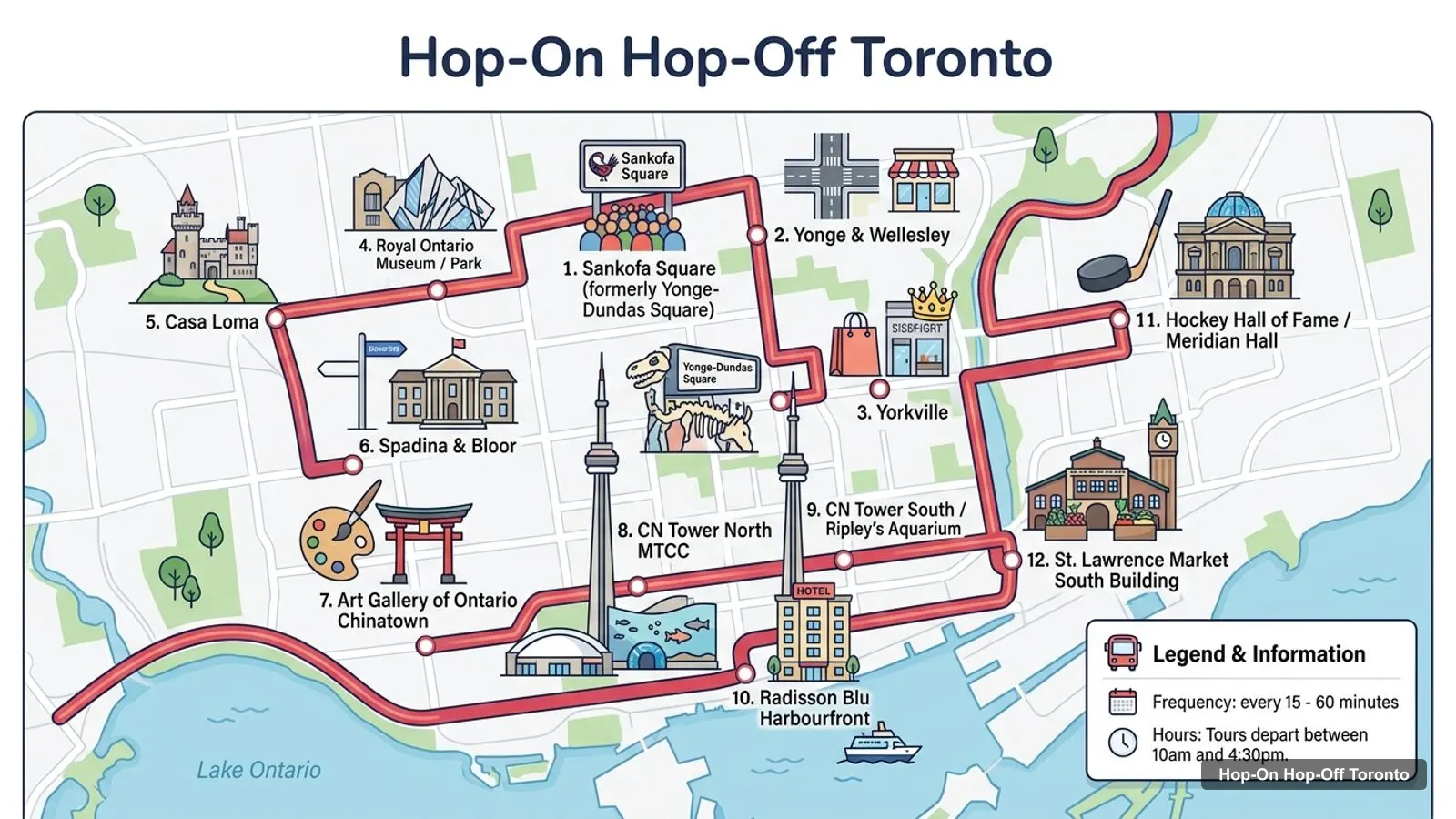
A Toronto tourist map makes sense once you see the city as four clusters between the lake and the hill. I’ve put the top 20 attractions (ranked by Google Maps reviews) and all 13 sightseeing bus stops on one page, with coordinates and a Google Maps link for each. The route image follows City Sightseeing’s loop, the only hop-on hop-off route on GetYourGuide in Toronto. To pick the ticket that rides it, see my comparison of hop-on hop-off in Toronto.
The Toronto travel map below shows the City Sightseeing loop. It starts at Sankofa Square, formerly Yonge-Dundas Square, runs north to Yorkville and Casa Loma, then south to the CN Tower and east along the waterfront to the Distillery District. A full loop takes 2 hours to 2 hours 15 minutes. In October, buses leave every 30 to 45 minutes between 9am and 4pm. In high summer it’s every 15 to 20 minutes, and from mid November to March every 2 hours.
Stops on the route
| # | Stop | Map |
|---|---|---|
| 1 | Sankofa Square (formerly Yonge-Dundas Square) | Find on Google Maps |
| 2 | Yonge & Wellesley | Find on Google Maps |
| 3 | Yorkville | Find on Google Maps |
| 4 | Royal Ontario Museum / Park Hyatt | Find on Google Maps |
| 5 | Casa Loma | Find on Google Maps |
| 6 | Spadina & Bloor | Find on Google Maps |
| 7 | Art Gallery of Ontario / Chinatown | Find on Google Maps |
| 8 | CN Tower North / MTCC | Find on Google Maps |
| 9 | CN Tower South / Ripley’s Aquarium | Find on Google Maps |
| 10 | Radisson Blu / Harbourfront | Find on Google Maps |
| 11 | Hockey Hall of Fame / Meridian Hall | Find on Google Maps |
| 12 | St. Lawrence Market South Building | Find on Google Maps |
| 13 | Distillery District | Find on Google Maps |
The route image numbers stops 1 to 12. Stop 13, the Distillery District, is at the eastern end of the loop. Mobile vouchers work at any stop. Paper vouchers have to be redeemed at stop 1 first.
These are the top Toronto tourist attractions in table form, ranked by Google Maps reviews, with exact coordinates. I left out tour companies that show up in Google Maps results. Each link opens the place in Google Maps, where you can save it to a list before you travel.
| # | Attraction | Coordinates | Google rating | Map |
|---|---|---|---|---|
| 1 | CN Tower | 43.64257, -79.38706 | 4.6 (89,813) | Open in Google Maps |
| 2 | Ripley’s Aquarium of Canada | 43.64218, -79.38660 | 4.6 (70,800) | Open in Google Maps |
| 3 | Royal Ontario Museum | 43.66771, -79.39478 | 4.7 (44,229) | Open in Google Maps |
| 4 | Nathan Phillips Square | 43.65271, -79.38341 | 4.6 (41,208) | Open in Google Maps |
| 5 | Casa Loma | 43.67804, -79.40944 | 4.5 (34,719) | Open in Google Maps |
| 6 | The Distillery Historic District | 43.65025, -79.35913 | 4.6 (26,849) | Open in Google Maps |
| 7 | Art Gallery of Ontario | 43.65361, -79.39251 | 4.7 (19,745) | Open in Google Maps |
| 8 | Ontario Science Centre | 43.63879, -79.38289 | 4.4 (14,924) | Open in Google Maps |
| 9 | Hockey Hall of Fame | 43.64727, -79.37769 | 4.7 (8,014) | Open in Google Maps |
| 10 | Aga Khan Museum | 43.72525, -79.33222 | 4.5 (7,206) | Open in Google Maps |
| 11 | Toronto Music Garden | 43.63696, -79.39430 | 4.7 (5,566) | Open in Google Maps |
| 12 | Roundhouse Park | 43.64127, -79.38530 | 4.5 (5,376) | Open in Google Maps |
| 13 | Harbour Square Park | 43.64019, -79.37665 | 4.6 (4,303) | Open in Google Maps |
| 14 | HTO Park | 43.63780, -79.38817 | 4.6 (4,078) | Open in Google Maps |
| 15 | Pocket Planet Canada | 43.65697, -79.38048 | 4.9 (3,987) | Open in Google Maps |
| 16 | Berczy Park | 43.64810, -79.37520 | 4.7 (3,923) | Open in Google Maps |
| 17 | The Village at Black Creek | 43.77344, -79.51691 | 4.6 (3,302) | Open in Google Maps |
| 18 | Trillium Park | 43.63007, -79.40986 | 4.8 (3,283) | Open in Google Maps |
| 19 | Tommy Thompson Park | 43.63521, -79.32485 | 4.7 (3,082) | Open in Google Maps |
| 20 | Fort York National Historic Site | 43.63924, -79.40414 | 4.5 (2,708) | Open in Google Maps |
Two notes on the table. The Ontario Science Centre’s listing shows it closed every day, at an address by Harbourfront Centre, so check its official site first. The Aga Khan Museum and the Village at Black Creek are well outside downtown, about 8.6 km and 17 km from Sankofa Square.
Read the coordinates above and you’ll see four groups on the Toronto visitor map:
Plan one cluster per half day and you won’t waste time crossing the city. My guide to the best things to do in Toronto says what to see at each place, and my Toronto itinerary turns the clusters into 1, 2 and 3-day plans.
This Toronto tourist guide matches the main attractions to the bus stops in the City Sightseeing listing:
Is Toronto worth visiting? Going by the map, yes, and it’s compact enough for a short trip. Ten of the top 20 attractions have a sightseeing bus stop named after them or within about 200 metres, and most of the rest are a short walk from one. The CN Tower alone has 89,813 Google reviews. The Royal Ontario Museum, the Art Gallery of Ontario and the Hockey Hall of Fame are all rated 4.7. Two days covers the four clusters, and a third day leaves room for Niagara Falls.
What is Toronto famous for, judged by this map? The CN Tower first, then the lakefront and the Toronto Islands, which you see best from the water. The Toronto Skyline Viewpoint at the ferry dock is rated 4.8 on Google Maps. After that come hockey, Casa Loma and the Distillery District’s old industrial streets.
Several bus stops sit at intersections that share a name with a TTC subway station. On the uptown stretch, Yonge and Wellesley is by Wellesley station, and Spadina and Bloor is by Spadina station. Those are the easiest places to switch between the sightseeing bus and the subway. The outer sights in the top 20, like the Aga Khan Museum and the Village at Black Creek, are better reached by subway, bus or taxi. For live routes and fares, use the TTC trip planner.
If you want a printable Toronto tourist map, print this page: the route image and the two tables fit on a few sheets and keep the stop numbers next to the sights. For a PDF, use your browser’s Print to PDF option, which keeps the Google Maps links clickable on a phone or tablet. I’d also save the 20 attractions to a starred list in Google Maps. It takes a couple of minutes with the links above, and the list works offline once you download the downtown area. The City Sightseeing Toronto app adds real-time bus tracking on top, so you can see on your own map when the next bus reaches your stop.
If you’d rather walk part of the Toronto tourist map, the waterfront is the easy stretch. From the Toronto Music Garden, Queens Quay runs east past HTO Park, Harbourfront Centre and Harbour Square Park. It’s flat, and every sight on it is within a kilometre or so of the CN Tower. From Harbour Square Park, walk north to the Hockey Hall of Fame and Berczy Park in under 15 minutes. The uptown cluster is the one I wouldn’t walk to: the Royal Ontario Museum is about 1.75 km north of Sankofa Square, and Casa Loma sits on a hill another 1.65 km beyond it.
All three Toronto hop-on hop-off tickets on GetYourGuide ride the same 13-stop loop, so they cover exactly the same Toronto tourist map. The difference is the extras: a harbour cruise or a Niagara Falls day trip. If you want the bus tour I’d book in Toronto for this route, it’s in my Toronto sightseeing bus comparison, and the rest of my city maps start from the homepage.
City Sightseeing Worldwide
My pick: Covers every stop on this map for $50: the full 13-stop loop, 24 or 48 hours.
This page works as one: the route image shows the sightseeing bus loop with numbered stops, and the tables list all 13 bus stops and the top 20 attractions with coordinates. Print the page, or open the Google Maps links to save the places to your phone so they work offline.
In four clusters. The waterfront has the CN Tower, Ripley's Aquarium, Roundhouse Park and the harbour parks. Downtown has Nathan Phillips Square and the Art Gallery of Ontario. Uptown has the Royal Ontario Museum and Casa Loma. Old Town has the Hockey Hall of Fame, Berczy Park and the Distillery District.
The CN Tower and Ripley's Aquarium are about 60 metres apart. The CN Tower to the Hockey Hall of Fame is about 900 metres, and to the Distillery District about 2.4 km. Casa Loma is the outlier: about 4.3 km from the CN Tower and 1.7 km beyond the Royal Ontario Museum.
The CN Tower, which is the most-reviewed attraction in the city with 89,813 Google reviews. Toronto is also known for its lakefront on Lake Ontario, the Toronto Islands, the Hockey Hall of Fame, a castle in the middle of the city (Casa Loma) and big museums like the Royal Ontario Museum and the Art Gallery of Ontario.
My full review of each one, in the order I rank them: