SKY HOP BUS
Tokyo: Hop-On Hop-Off Sightseeing Bus Ticket
- 3.9 (5,479 reviews)
- 2-day ticket
My pick: The only Tokyo ticket with a full stop list: 17 stops across three routes from $30.36.
By Jake Dawson · Updated · Affiliate links, explained in my disclosure
A Tokyo tourist map has to do two jobs: show where the sights are, and show how far apart they are. This page does both with the data I collected, and it ties the sights to the stops of the Sky Hop Bus, the open-top network I cover in my guide to hop-on hop-off Tokyo. Every coordinate comes from Google Maps place data, and every stop name is the one the operator prints.
I have not walked these routes, so distances are straight lines between coordinates and real journeys are longer. Use the Google Maps links to get live directions.
The Tokyo sightseeing map starts at Marunouchi, where all three Sky Hop Bus routes begin. The numbered map below shows the stops the infographic covers, and the table lists each one with a Google Maps link.
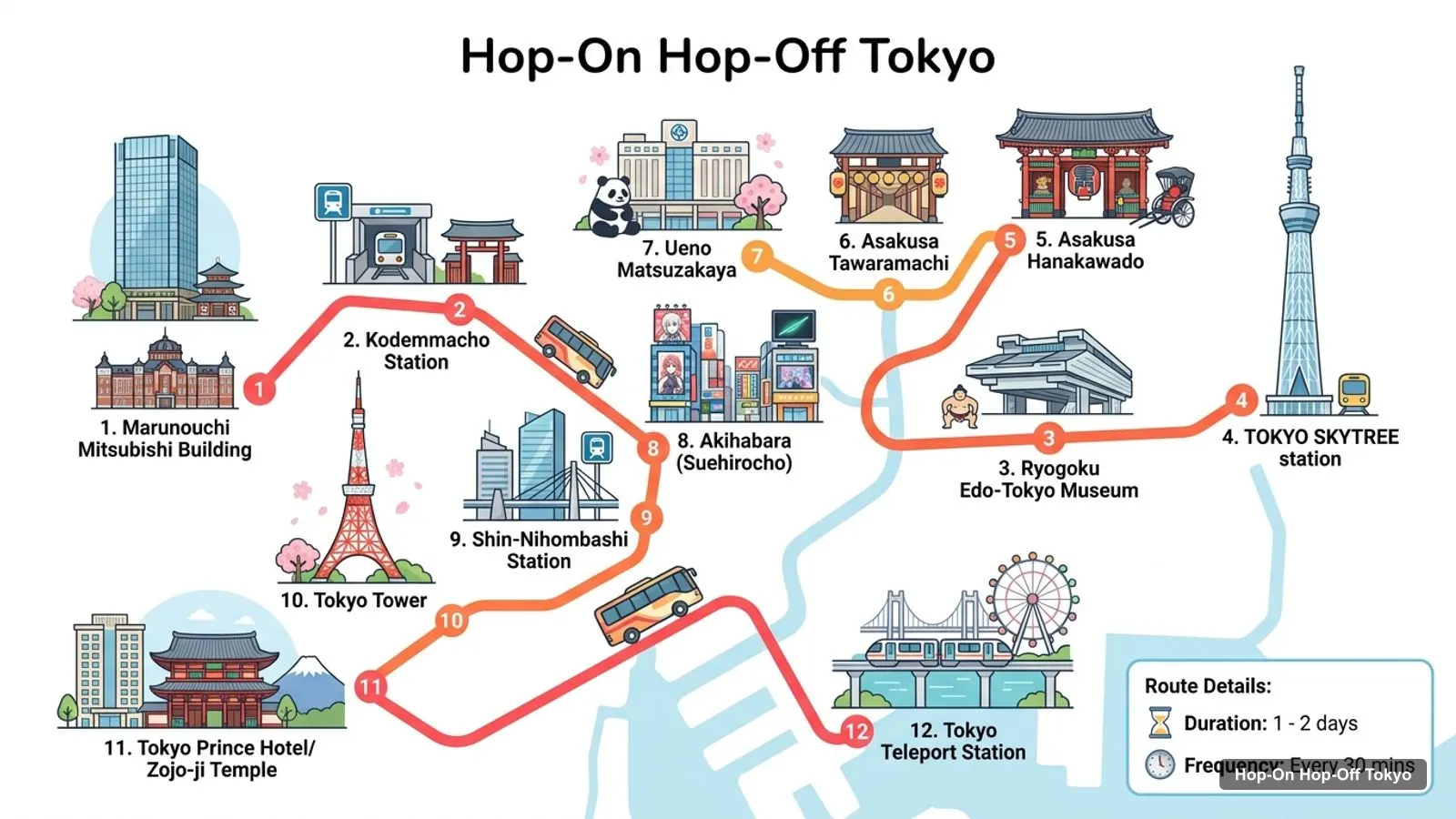
Stops on the route
| # | Stop | Map |
|---|---|---|
| 1 | Marunouchi Mitsubishi Building | Find on Google Maps |
| 2 | Kodemmacho Station | Find on Google Maps |
| 3 | Ryogoku Edo-Tokyo Museum | Find on Google Maps |
| 4 | TOKYO SKYTREE station | Find on Google Maps |
| 5 | Asakusa Hanakawado | Find on Google Maps |
| 6 | Asakusa Tawaramachi | Find on Google Maps |
| 7 | Ueno Matsuzakaya | Find on Google Maps |
| 8 | Akihabara (Suehirocho) | Find on Google Maps |
| 9 | Shin-Nihombashi Station | Find on Google Maps |
| 10 | Tokyo Tower | Find on Google Maps |
| 11 | Tokyo Prince Hotel/Zojo-ji Temple | Find on Google Maps |
| 12 | Tokyo Teleport Station | Find on Google Maps |
The full list has 17 stops. The five stops that are not on the map above are Shinjuku-gyoemmae Station, Shinjuku Station South Exit and the Hotel Century Southern Tower, the Shinjuku Mitsui Building in Nishi-Shinjuku, Tsukiji Ginza, and the Shibuya City Hall, Harajuku and Meiji Jingu Shrine stop, which are on routes 2 and 3.
The Tokyo sights map below ranks the 20 most-reviewed attractions in my data. I left out bus stops, the bus operator and duplicate entries such as the Tokyo Tower main deck.
| # | Attraction | Coordinates | Google rating | Map |
|---|---|---|---|---|
| 1 | Tokyo Skytree | 35.71006, 139.81070 | 4.4 (120,419) | Open in Google Maps |
| 2 | Tokyo Tower | 35.65858, 139.74543 | 4.5 (101,154) | Open in Google Maps |
| 3 | Sensō-ji | 35.71477, 139.79666 | 4.6 (99,637) | Open in Google Maps |
| 4 | teamLab Planets TOKYO DMM | 35.64912, 139.78977 | 4.5 (56,906) | Open in Google Maps |
| 5 | Meiji Jingu | 35.67640, 139.69933 | 4.7 (53,459) | Open in Google Maps |
| 6 | Shinjuku Gyoen National Garden | 35.68518, 139.71005 | 4.6 (45,853) | Open in Google Maps |
| 7 | Tokyo National Museum | 35.71884, 139.77652 | 4.5 (31,496) | Open in Google Maps |
| 8 | teamLab Borderless: MORI Building DIGITAL ART MUSEUM | 35.66207, 139.74327 | 4.6 (30,389) | Open in Google Maps |
| 9 | Yoyogi Park | 35.67006, 139.69497 | 4.4 (27,610) | Open in Google Maps |
| 10 | Shibuya Sky | 35.65867, 139.70198 | 4.6 (27,188) | Open in Google Maps |
| 11 | Hachiko Statue | 35.65906, 139.70063 | 4.4 (26,869) | Open in Google Maps |
| 12 | The National Art Center, Tokyo | 35.66529, 139.72637 | 4.4 (22,635) | Open in Google Maps |
| 13 | Ghibli Museum | 35.69624, 139.57043 | 4.5 (20,088) | Open in Google Maps |
| 14 | Tokyo Metropolitan Art Museum | 35.71721, 139.77294 | 4.3 (16,194) | Open in Google Maps |
| 15 | Omoide Yokocho Memory Lane | 35.69270, 139.69958 | 4.2 (15,596) | Open in Google Maps |
| 16 | Tokyo Skytree Town | 35.70993, 139.81166 | 4.5 (15,350) | Open in Google Maps |
| 17 | Edo-Tokyo Museum | 35.69660, 139.79573 | 4.4 (14,918) | Open in Google Maps |
| 18 | Shinjuku Golden-Gai | 35.69411, 139.70476 | 4.3 (13,216) | Open in Google Maps |
| 19 | The National Museum of Western Art | 35.71539, 139.77581 | 4.5 (12,265) | Open in Google Maps |
| 20 | Tokyo Dome City | 35.70534, 139.75211 | 4.3 (11,395) | Open in Google Maps |
Tokyo Skytree leads with 120,419 reviews, followed by Tokyo Tower with 101,154 and Sensō-ji with 99,637. The highest rating in the top five is Meiji Jingu at 4.7.
The Tokyo sites map falls into four clusters, and picking one cluster per day saves more time than any ticket does.
Matching sights to stops is the part that a plain map does not do. Here is the match, using the stop names the operator lists.
| Sight | Nearest named stop | Route |
|---|---|---|
| Tokyo Skytree | TOKYO SKYTREE station | 1 |
| Sensō-ji | Asakusa Hanakawado or Asakusa Tawaramachi | 1 |
| Edo-Tokyo Museum | Ryogoku Edo-Tokyo Museum | 1 |
| Tokyo National Museum | Ueno Matsuzakaya (check the walk) | 1 |
| Tokyo Tower | Tokyo Tower | 2 |
| Shinjuku Gyoen | Shinjuku-gyoemmae Station | 3 |
| Meiji Jingu | Shibuya City Hall, Harajuku, Meiji Jingu Shrine | 3 |
I have no walking times between these stops and the sights, and I would rather you check a live map than trust a guess.
A Tokyo tourist map PDF is a popular search, but I have not found an official one I can verify. The operators’ own pages are the right place to look for a printed route map. Until then, the tables above give you the same information: open any Google Maps link, then download the area for offline use in the app. If you are planning days around the map, my Tokyo itinerary puts the clusters into order.
The same advice holds for an attractions map PDF or a sightseeing map PDF. I would not trust a file I cannot source. Use the coordinates in the top-20 table to build your own custom map in Google Maps, and mark the opening hours: for example, Tokyo National Museum and Shinjuku Gyoen are listed closed on Tuesdays, and Edo-Tokyo Museum is listed closed on Mondays.
The metro is how you will reach the sights with no bus stop. The Tokyo tourism site lists the Tokyo Metro 24-hour ticket at 700 yen for adults and 350 for children, valid for 24 hours after first use on all Tokyo Metro lines. The Tokyo Subway Ticket, which also covers the Toei lines, costs 1,000 yen for 24 hours, 1,500 for 48 and 2,000 for 72. You can check the figures on the Tokyo tourism ticket guide.
I would use the bus for the landmarks and the metro for teamLab, Ghibli and the museums in Ueno.
Walking is realistic inside a cluster and unrealistic between them. Inside the western cluster, Meiji Jingu and Yoyogi Park are 0.8 km apart in a straight line, and Shibuya Sky and the Hachiko Statue are about 0.1 km apart. In the east, Skytree to Sensō-ji is 1.4 km. Between clusters the numbers jump: Tokyo Skytree to Tokyo Tower is 8.2 km, and Tokyo Tower to Meiji Jingu is 4.6 km.
My rule is simple. Walk inside a cluster, ride between clusters, and let the bus or metro do the long legs. Tokyo is also hot in summer: the 2025 average high was 33.3 degrees C in August, so carry water on the long walks.
A map does not tell you when a place is shut, so here are the closures I found in the Google Maps data. Shinjuku Gyoen, Tokyo National Museum and the Ghibli Museum are listed closed on Tuesdays. Edo-Tokyo Museum, the Tokyo Metropolitan Art Museum and the National Museum of Western Art are listed closed on Mondays. Shinjuku Gyoen closes at 4:30 PM, and Tokyo Tower is listed open 9 AM to 11 PM.
Several places on the map are open all day: Yoyogi Park, the Hachiko Statue, Omoide Yokocho and Shinjuku Golden-Gai. Check the official site on the day you go, as holiday closures can change these hours.
If it is your first visit, I’d use the tourist map in three passes. First, pick the two clusters that matter most to you from the list above, because trying all four in a short trip means a lot of time on trains. Second, use the top-20 table to choose three sights in each cluster, and open their Google Maps links to see the real route from your hotel. Third, match each sight to the stop table so you know whether the bus can take you, or whether the metro is the better option.
The map also shows what the bus does not do. It does not reach the Ghibli Museum, teamLab or most of the Ueno museums, and the data gives no walking times from its stops to the sights. For a day-by-day version of this idea, see the plan on my Tokyo itinerary page, which keeps each day inside one cluster.
The Sky Hop Bus covers the most of this map, with 17 stops across three routes from $30.36 for a 1-day ticket. The 70-minute loop from Tokyo Station covers Tokyo Station, Tokyo Tower and Ginza and costs $12.65 but does not let you get off. For the sights themselves, see my list of the best things to do in Tokyo. To compare all three tickets side by side, read my Tokyo bus tour comparison, or go back to the homepage for other cities.
SKY HOP BUS
My pick: The only Tokyo ticket with a full stop list: 17 stops across three routes from $30.36.
I do not have an official PDF to link, and I would rather not point you to one I have not checked. What I do have is the stop table and the top-20 attraction table below, with a Google Maps link for each row. You can open any link and save the area offline in the Google Maps app.
The Sky Hop Bus lists 17 stops across three routes, all starting at the Marunouchi Mitsubishi Building next to Tokyo Station. Route 1 covers Skytree, Asakusa and Ueno, route 2 covers Tokyo Tower and Ginza, and route 3 covers Shinjuku, Shibuya and Harajuku. The table below links each one.
I group the sights into four clusters: Marunouchi, Ginza and Tokyo Tower in the centre; Asakusa, Skytree and Ueno in the east and north; Shinjuku, Shibuya and Harajuku in the west; and the waterfront at Toyosu and Odaiba. Most of my top-20 sights sit in the first three.
Distances are large. In a straight line from the Marunouchi start, Tokyo Tower is 2.9 km, Sensō-ji 4.9 km, Skytree 5.4 km and Meiji Jingu 5.8 km. Tokyo Skytree to Tokyo Tower is 8.2 km. These are straight lines from Google Maps coordinates, so real trips are longer.
For reaching specific sights, the metro is cheaper and quicker. The Tokyo Metro 24-hour ticket is 700 yen for adults according to the Tokyo tourism site. The bus is better if you want an open-top loop that links Skytree, Asakusa, Tokyo Tower and Shinjuku with a commentary on one ticket.
In my data, teamLab Planets, teamLab Borderless, Tokyo National Museum, Yoyogi Park, Shibuya Sky and the Ghibli Museum have no named stop. The Ghibli Museum is in Mitaka, about 17.6 km in a straight line from Marunouchi. For those you will need the metro or a walk from the nearest bus stop.
My full review of each one, in the order I rank them: