Santiago Tourist Map: Top Attractions & Bus Stops
By Jake Dawson · Updated · Affiliate links, explained in my disclosure

Turistik
Santiago: 1-Day Hop-On Hop-Off Bus and Cable Car Ticket
4.3 (394) · from $67
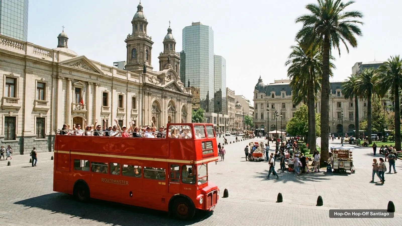
A Santiago tourist map makes more sense once you see the city as three groups of sights along one long axis. I’ve put the 10 hop-on hop-off bus stops and the top 20 attractions (ranked by Google Maps reviews) on one page, with coordinates and a Google Maps link for each. The route map comes from the same stop list that I use in my guide to hop-on hop-off bus tours in Santiago.
Data comes from the GetYourGuide listings and Google Maps, checked in October 2026. Coordinates for attractions are Google’s; stop addresses are those printed in the listings, so the pin may be a few metres off the real bus sign.
Santiago Sightseeing Map: The Bus Route
The Santiago sightseeing map below shows the Turistik loop: 10 stops from Parque Arauco in Las Condes to the Las Condes Interactive Museum, passing the cable car and funicular, Plaza de Armas, La Moneda and Santa Lucía Hill on the way. A full circuit takes about 2 hours without getting off, and buses run from about 9:20 AM to 6:00 PM. Board before 4:00 PM if you want a full loop.
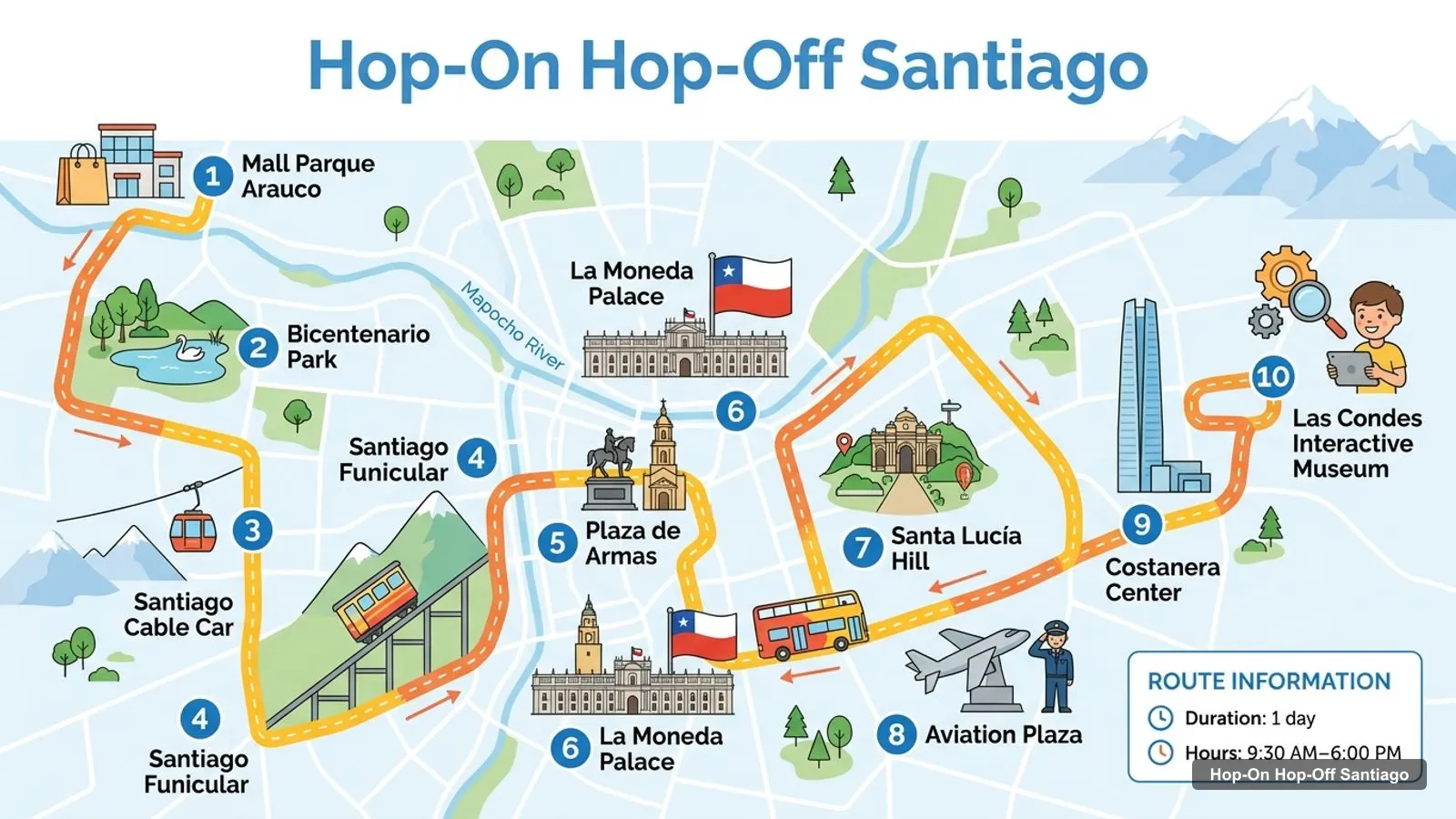
Stops on the route
- 1Mall Parque Arauco
- 2Bicentenario Park
- 3Santiago Cable Car
- 4Santiago Funicular
- 5Plaza de Armas
- 6La Moneda Palace
- 7Santa Lucía Hill
- 8Aviation Plaza
- 9Costanera Center
- 10Las Condes Interactive Museum
Bus stops on the loop
| # | Stop | Address from the listing | Map |
|---|---|---|---|
| 1 | Mall Parque Arauco | Av. Presidente Kennedy 5601, Las Condes | Find on Google Maps |
| 2 | Bicentenario Park | Isabel Montt & Av. Bicentenario, Vitacura | Find on Google Maps |
| 3 | Santiago Cable Car | Los Conquistadores & Pedro de Valdivia Norte, Providencia | Find on Google Maps |
| 4 | Santiago Funicular | Pío Nono 445, Providencia | Find on Google Maps |
| 5 | Plaza de Armas | Plaza de Armas 2, Santiago | Find on Google Maps |
| 6 | La Moneda Palace | Teatinos 254, Santiago | Find on Google Maps |
| 7 | Santa Lucía Hill | Av. Libertador Bernardo O’Higgins 390, Santiago | Find on Google Maps |
| 8 | Aviation Plaza | Av. Providencia 835, Providencia | Find on Google Maps |
| 9 | Costanera Center | Av. Andrés Bello 2425, Providencia | Find on Google Maps |
| 10 | Las Condes Interactive Museum | Isidora Goyenechea 3365, Las Condes | Find on Google Maps |
Turistik’s own site currently lists 13 stops, and the GetYourGuide listings list 10, so use the stop list in your voucher or the Turistik app, which tracks stops and buses in real time. A rider on the 2-day listing also wrote that one stop had no sign, which is a good reason to check the pin on a map.
Santiago Attractions Map: Top 20 Sights with Coordinates
This is the Santiago attractions map in table form, ranked by Google Maps reviews, with exact coordinates. Each link opens the place in Google Maps, where you can save it before you travel.
| # | Attraction | Coordinates | Google rating | Map |
|---|---|---|---|---|
| 1 | Plaza de Armas de Santiago | -33.43782, -70.65049 | 4.2 (84,980) | Open in Google Maps |
| 2 | Bicentennial Park | -33.39863, -70.60248 | 4.8 (55,435) | Open in Google Maps |
| 3 | Santiago Central Market | -33.43343, -70.65111 | 4.2 (50,893) | Open in Google Maps |
| 4 | Araucano Park | -33.40220, -70.57249 | 4.7 (40,300) | Open in Google Maps |
| 5 | Sky Costanera | -33.41696, -70.60677 | 4.7 (27,703) | Open in Google Maps |
| 6 | Mirador Interactive Museum | -33.51948, -70.61197 | 4.7 (19,954) | Open in Google Maps |
| 7 | La Moneda Cultural Center | -33.44375, -70.65381 | 4.6 (17,450) | Open in Google Maps |
| 8 | National Museum of Fine Arts | -33.43531, -70.64354 | 4.6 (17,066) | Open in Google Maps |
| 9 | Santa Lucía Hill | -33.44024, -70.64342 | 4.7 (16,210) | Open in Google Maps |
| 10 | Museum of Memory & Human Rights | -33.44010, -70.67954 | 4.7 (14,772) | Open in Google Maps |
| 11 | National Museum of Natural History | -33.44176, -70.68157 | 4.7 (12,629) | Open in Google Maps |
| 12 | Chilean Museum of Pre-Columbian Art | -33.43867, -70.65239 | 4.7 (10,737) | Open in Google Maps |
| 13 | National Aerospace Museum | -33.48766, -70.69681 | 4.8 (7,386) | Open in Google Maps |
| 14 | Museum of National History of Chile | -33.43704, -70.65070 | 4.7 (6,145) | Open in Google Maps |
| 15 | Metropolitan Cathedral of Santiago | -33.43762, -70.65184 | 4.7 (6,045) | Open in Google Maps |
| 16 | La Chascona | -33.43112, -70.63442 | 4.6 (5,429) | Open in Google Maps |
| 17 | La Moneda Palace | -33.44240, -70.65393 | 4.6 (3,349) | Open in Google Maps |
| 18 | Casa de los Diez | -33.44615, -70.64549 | 4.5 (2,601) | Open in Google Maps |
| 19 | Museo de Artes Visuales MAVI UC | -33.43764, -70.64078 | 4.5 (2,378) | Open in Google Maps |
| 20 | Military and Historical Museum of Chile | -33.45663, -70.65625 | 4.7 (2,124) | Open in Google Maps |
Two of the 20 are far from the route. The National Aerospace Museum is in Cerrillos, about 7 km from Plaza de Armas, and the Mirador Interactive Museum is in La Granja, 9.8 km away and about 14 km from the bus’s first stop. The Mirador is not the Las Condes Interactive Museum on the route.
Santiago Tourist Attractions: The Three Clusters
Read the coordinates above and you’ll see three groups on the Santiago tourist map:
- The historic centre (around -33.44, -70.65): Plaza de Armas, the Cathedral, the National History Museum, the Pre-Columbian Art Museum, the Central Market, La Moneda and its cultural center. Santa Lucía Hill is 0.7 km from the plaza and the Central Market 0.5 km. You can cover this cluster on foot in a morning.
- Bellavista and Providencia (around -33.43, -70.63): the funicular, La Chascona and the foot of San Cristóbal Hill. La Chascona is 1.7 km from Plaza de Armas and 1.3 km from Santa Lucía Hill.
- The east side (around -33.40, -70.59): Bicentenario Park, Araucano Park, Sky Costanera and Parque Arauco. Bicentenario Park is 6.2 km from the plaza and Araucano Park 8.3 km, so this is where the bus saves time.
A fourth, smaller group sits west at Quinta Normal: the Museum of Memory and Human Rights and the National Museum of Natural History, 2.7 and 2.9 km from the plaza. The bus doesn’t go there, but the address of the Museum of Memory names a metro station. My best things to do in Santiago guide says what to see in each place, and my Santiago itinerary turns the clusters into 1, 2 and 3-day plans.
Historical Sites in Santiago, Chile
The historical sites in Santiago, Chile, cluster around Plaza de Armas. The Cathedral (4.7, 6,045 reviews) is at number 498, 183 m from the stop. The National History Museum (4.7) is at number 951 and the Pre-Columbian Art Museum (4.7) is at Bandera 361, 264 m away. La Moneda Palace, stop 6 on the loop, is the government seat. Casa de los Diez (4.5, 2,601 reviews) and the Military and Historical Museum (4.7, 2,124 reviews) are further out in my data. The city’s official site, Municipalidad de Santiago, covers events on the plaza.
Which Stop for Which Sight on the Santiago Tourist Map
The Santiago tourist map gets easier once you know which stop serves which sight. Here is how the main attractions line up with the stops, using the listings and the walking routes I calculated:
- Plaza de Armas, the Cathedral, the National History Museum: stop 5. The Cathedral is 2 minutes on foot, the Pre-Columbian Art Museum 4, the Central Market 8.
- La Moneda Palace and its cultural center: stop 6. The cultural center is 359 m away, about 5 minutes.
- Santa Lucía Hill, Lastarria and the Fine Arts museum: stop 7. Paseo Lastarria is 8 minutes (620 m) and the Fine Arts museum 11 minutes (817 m) from the hill.
- Sky Costanera: stop 9, Costanera Center, where the tower is in the same complex.
- San Cristóbal Hill: stops 3 (cable car, a 5-minute walk from the stop) and 4 (funicular, Pío Nono 445).
- Bicentenario Park and Araucano Park: stop 2, and stop 1 (Araucano Park is 0.4 km from the Parque Arauco meeting point).
Reading the Santiago Tourist Map Before You Go
Before you use the Santiago tourist map, decide how you will travel between clusters. Inside the historic centre I would walk, because the distances are 200 to 800 metres. Between clusters I would take the bus or the metro. A straight-line distance in the tables is a guide, not a route, and real walking paths are longer, so open the Google Maps link before you set out. Save the places you want to a list in Google Maps and the Santiago tourist map becomes a personal one on your phone, which works well offline if you download the area first.
Opening hours matter as much as distance. Plaza de Armas is open 24 hours, but several museums close on Mondays and most close by 6 PM. If you only have one afternoon in the centre, check the day of the week first.
Santiago Places to Visit: Metro Tips
The metro is the cheapest way to fill the gaps. A single adult ride costs 735 to 895 pesos depending on the time band, about $0.75 to $0.92 at 974 pesos to the dollar, and the bip! card costs 1,550 pesos plus a 750-peso initial top-up, according to Metro de Santiago. Several places I list have a station in their address: the Museum of Memory, La Moneda Cultural Center, Casa de los Diez and the Railway Museum.
Santiago Tourist Guide: Which Ticket Fits This Map
If you want to see the east side and the hill in one day, a bus ticket is easier than the metro. The 1-day bus and cable car ticket costs $67 and the 2-day pass $73, and both are in my full Santiago ticket comparison. For the centre alone, I’d walk. Head back to the homepage for the maps of other cities.
Frequently asked questions
Is there a printable Santiago tourist map?
This page works as one. The route map image shows the 10 numbered bus stops, and the tables below list every stop and the top 20 attractions with coordinates. Print the page, or open any Google Maps link to save the places to a list before you travel.
Where are most Santiago attractions on the map?
In the historic centre, within about 700 m of Plaza de Armas. The Cathedral, the National History Museum, the Pre-Columbian Art Museum, the Central Market, La Moneda and Santa Lucía Hill are all that close. The parks, Sky Costanera and the malls are 4 to 8 km east, which is where the bus helps.
How far apart are the main Santiago sights?
Plaza de Armas to Santa Lucía Hill is about 0.7 km in a straight line, and to Sky Costanera about 4.7 km. Bicentenario Park is 6.2 km from the plaza, and Araucano Park is 8.3 km. The Quinta Normal museums are 2.7 to 2.9 km west of the plaza.
How many bus stops does the Santiago hop-on hop-off have?
Ten, in the GetYourGuide listings: from Parque Arauco mall in Las Condes to the Las Condes Interactive Museum. Turistik's own website currently shows 13 stops, so your voucher is the final word. The full circuit takes about 2 hours without getting off.
Tours I compared in Santiago
My full review of each one, in the order I rank them:
- Santiago: 1-Day Hop-On Hop-Off Bus and Cable Car Ticket★ 4.3 · from $67
- Santiago: Hop-On Hop-Off, Cerro San Cristóbal & Adventure★ 4.4 · from $73
- HOP ON HOP OFF Panoramic double-decker bus tour of Santiago★ 4.1 · from $83
- Hop-On Hop-Off Bus Santiago - 10 Stops, 1-Day Ticketfrom $54.90
- City Tour in Santiago Hop On Hop Off+Tranfer In-Out Airportfrom $120