Green Line Tours
Rome Hop-On Hop-Off Bus Tour: Full Access to 3 Scenic Routes
- 3.9 (19,335 reviews)
- 3-day ticket
- Free cancellation
My pick: Covers the most of this map: three routes, from the Pyramid in the south to the MAXXI in the north.
By Jake Dawson · Updated · Affiliate links, explained in my disclosure
Sightseeing Experience
Rome: City Sightseeing Hop-on Hop-off Bus with Audioguide
4.0 (18,751) · from $17.23
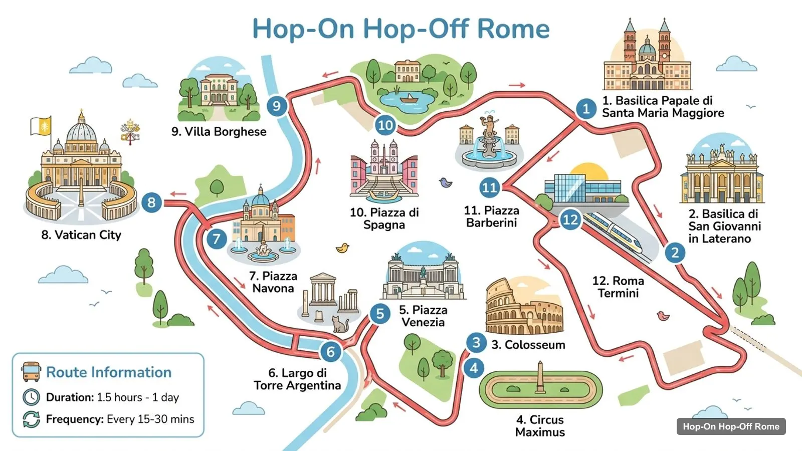
A Rome tourist map makes more sense once you see the city as four groups of sights, with the Tiber running between them. I’ve put the top 20 attractions (ranked by Google Maps reviews) and the main sightseeing bus stops on one page, with coordinates and a Google Maps link for each. The route image follows City Sightseeing’s 12-stop loop. To pick the ticket that rides it, see my comparison of hop-on hop-off in Rome.
The Rome sightseeing map below shows City Sightseeing’s loop: 12 stops from Santa Maria Maggiore past the Colosseum and Circus Maximus, through Piazza Venezia and Piazza Navona to the Vatican, then back via Villa Borghese, Piazza di Spagna and Piazza Barberini to Termini. A full loop takes 100 minutes.
Stops on the route
| # | Stop | Map |
|---|---|---|
| 1 | Basilica Papale di Santa Maria Maggiore | Find on Google Maps |
| 2 | Basilica di San Giovanni in Laterano | Find on Google Maps |
| 3 | Colosseum | Find on Google Maps |
| 4 | Circus Maximus | Find on Google Maps |
| 5 | Piazza Venezia | Find on Google Maps |
| 6 | Largo di Torre Argentina | Find on Google Maps |
| 7 | Piazza Navona | Find on Google Maps |
| 8 | Vatican City | Find on Google Maps |
| 9 | Villa Borghese | Find on Google Maps |
| 10 | Piazza di Spagna | Find on Google Maps |
| 11 | Piazza Barberini | Find on Google Maps |
| 12 | Roma Termini | Find on Google Maps |
The other operators share most of this spine. Big Bus lists 7 places on its route and says its Colosseum stop is currently closed, with Circo Massimo about a 10-minute walk away as the alternative. Green Line runs three routes and the longest network in my data, 17 numbered stops. The table above is the core loop most visitors ride first.
This is the Rome tourism map in table form, ranked by Google Maps reviews, with exact coordinates. Each link opens the place in Google Maps, where you can save it to a list before you travel.
| # | Attraction | Coordinates | Google rating | Map |
|---|---|---|---|---|
| 1 | Trevi Fountain | 41.90093, 12.48331 | 4.7 (525,468) | Open in Google Maps |
| 2 | Colosseum | 41.89021, 12.49223 | 4.8 (507,560) | Open in Google Maps |
| 3 | Pantheon | 41.89861, 12.47687 | 4.8 (288,646) | Open in Google Maps |
| 4 | Piazza Navona | 41.89916, 12.47307 | 4.7 (218,667) | Open in Google Maps |
| 5 | Vatican Museums | 41.90649, 12.45364 | 4.6 (211,395) | Open in Google Maps |
| 6 | Roman Forum | 41.89209, 12.48644 | 4.8 (146,609) | Open in Google Maps |
| 7 | Piazza del Popolo | 41.91070, 12.47636 | 4.7 (125,710) | Open in Google Maps |
| 8 | Spanish Steps | 41.90599, 12.48278 | 4.6 (113,277) | Open in Google Maps |
| 9 | Castel Sant’Angelo | 41.90306, 12.46628 | 4.7 (111,752) | Open in Google Maps |
| 10 | Sistine Chapel | 41.90295, 12.45448 | 4.7 (97,652) | Open in Google Maps |
| 11 | Villa Borghese | 41.91388, 12.48538 | 4.6 (96,091) | Open in Google Maps |
| 12 | Monument to Victor Emmanuel II | 41.89460, 12.48313 | 4.8 (77,958) | Open in Google Maps |
| 13 | Piazza Venezia | 41.89599, 12.48246 | 4.7 (58,668) | Open in Google Maps |
| 14 | Galleria Borghese | 41.91421, 12.49214 | 4.6 (30,657) | Open in Google Maps |
| 15 | Janiculum Hill | 41.89147, 12.46139 | 4.7 (26,110) | Open in Google Maps |
| 16 | Mouth of Truth | 41.88824, 12.48144 | 4.3 (25,975) | Open in Google Maps |
| 17 | Piazza del Campidoglio | 41.89336, 12.48280 | 4.7 (24,406) | Open in Google Maps |
| 18 | Capitoline Museums | 41.89294, 12.48256 | 4.7 (19,055) | Open in Google Maps |
| 19 | Fontana dei Quattro Fiumi | 41.89897, 12.47309 | 4.8 (14,846) | Open in Google Maps |
| 20 | MAXXI - National Museum of 21st Century Art | 41.92825, 12.46686 | 4.5 (13,026) | Open in Google Maps |
Read the coordinates above and you’ll see four tight groups on the Rome landmarks map:
Plan one group per half day and you won’t waste time crossing the city. My best things to do in Rome guide has what to see at each place, and my Rome itinerary turns the groups into 1, 2 and 3-day plans.
The Rome sites map gets easier once you know which stop serves which sight. Here’s how the main attractions line up with the bus stops in the operators’ listings:
A few of the top tourist spots on this map aren’t served by any sightseeing bus. The Janiculum Hill (4.7 from 26,110 reviews) is about 1.8 km from the Vatican Museums and has the best free view over the city, open 24 hours. The Mouth of Truth is about 900 metres south of the Colosseum, an easy walk from the Circus Maximus stop. Piazza del Popolo is about 750 metres north of the Spanish Steps. The Trevi Fountain and the Pantheon, two of the three most-reviewed sights in Rome, aren’t direct stops either, so plan to walk them from Piazza di Spagna, Largo Argentina or Piazza Navona.
The river is the other line on the Rome tourist map worth knowing. The Tiber hop-on hop-off boat runs a 1-hour round trip between Isola Tiberina and the St Peter’s area, with boarding points at Isola Tiberina (Lungotevere degli Anguillara) and Castel Sant’Angelo (Lungotevere Tor di Nona). Boats run from 10 AM to 6 PM and the ticket covers 2 consecutive days. It’s a slow, relaxed way to link the Vatican group with the southern edge of Ancient Rome, and it avoids the traffic around Piazza Venezia.
Each sightseeing bus company draws its own Rome tour map, and the routes differ more than the brochures suggest. City Sightseeing has the most stops in the historic centre, and it’s the only route with Largo di Torre Argentina and Piazza Navona. Its ticket also includes the Yellow Line run by Vatican & Rome Open. Big Bus and I Love Rome both start on Via Giovanni Giolitti 32 by Termini and cover the Spanish Steps. Green Line’s Green Route covers the classics, its Orange Route goes south to the Pyramid, Testaccio and Ostiense, and its Blue Route goes north to the Auditorium, the MAXXI, the Villa Giulia Etruscan Museum, the zoo and the Borghese Gallery. If one sight on this map is a must for you, check that your operator stops there before you book.
If you want a printable Rome tourist map, print this page: the route image and the two tables fit on a few sheets and keep the stop numbers next to the sights. For a Rome tourist map PDF, use your browser’s “Print to PDF” option, which keeps the Google Maps links clickable on a phone or tablet. I’d also save the 20 attractions to a starred list in Google Maps. It takes a couple of minutes with the links above, and the list works offline once the area is downloaded.
Rome’s metro is small and skips most of the historic centre, which is one reason the sightseeing buses are popular. The bus routes and the metro meet at Termini, where every operator starts. On a combined Rome tourist map with metro lines, Termini is the easiest place to switch. Ostiense station is a stop on Green Line’s Orange Route. For metro and city bus fares, the official source is ATAC, Rome’s transport authority.
If you’re walking rather than riding, the centre is the place to do it. The Spanish Steps, the Trevi Fountain, the Pantheon and Piazza Navona are each a short walk from the next: about 560 metres, then 600 metres, then 300 metres. Cross the Tiber at Castel Sant’Angelo to reach the Vatican, and use the bus for the long hop back to the Colosseum. Check opening days before you go: on Google Maps, the Vatican Museums are closed on Sundays, and Castel Sant’Angelo and the Galleria Borghese on Mondays.
Green Line covers the most of this tourist map in my data, with three routes that reach the north and south. In the historic centre, City Sightseeing covers more, with stops at Largo Argentina and Piazza Navona. If you want the bus tour I’d book in Rome for this route, it’s on my Rome sightseeing bus comparison, and the rest of my city maps start from the homepage.
Green Line Tours
My pick: Covers the most of this map: three routes, from the Pyramid in the south to the MAXXI in the north.
This page works as one: the route map image shows the sightseeing bus loop with 12 numbered stops, and the tables below list the top 20 attractions with coordinates and the bus stops with Google Maps links. Print the page, or open the links to save the places to your phone for offline use.
In four groups. Ancient Rome has the Colosseum, the Roman Forum and Piazza Venezia. The centre has the Trevi Fountain, the Pantheon, Piazza Navona and the Spanish Steps. The Vatican area has the Vatican Museums and Castel Sant'Angelo across the Tiber, and the north has Villa Borghese and the Galleria Borghese.
The Colosseum and the Vatican Museums are about 3.7 km apart as the crow flies, which is where a bus saves the most time. The centre is compact: the Trevi Fountain is about 600 metres from the Pantheon, and the Pantheon about 300 metres from Piazza Navona. Castel Sant'Angelo is about 1.1 km from the Vatican Museums.
My full review of each one, in the order I rank them: