A Paris tourist map makes more sense once you see the city as a few clusters along one river. I’ve put the top 20 attractions (ranked by Google Maps reviews) and the main sightseeing bus stops on one page, with coordinates and a Google Maps link for each. The route image follows the Big Bus listing. To pick the ticket that rides it, see my comparison of hop-on hop-off in Paris.
Paris Sightseeing Map: The Bus Route
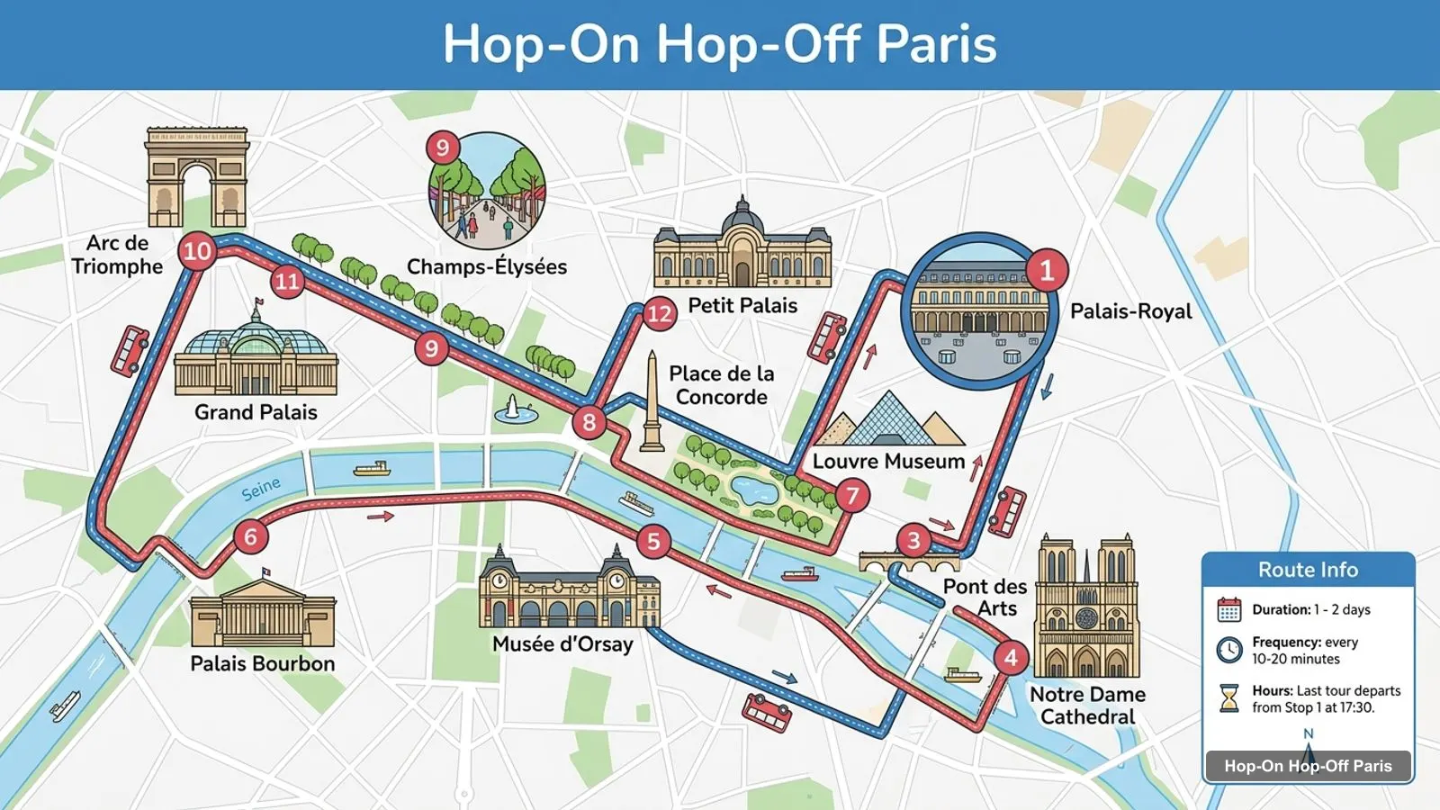
The Paris sightseeing map below shows the first 12 points on the Big Bus route, in the order of its listing: from Palais-Royal and the Louvre across to Notre-Dame, back along the Left Bank to Orsay, then up through Concorde and the Champs-Élysées to the Arc de Triomphe and the two palaces. Buses run every 10 to 20 minutes, and the last tour leaves Stop 1 at 5:30pm. A full loop takes about 2 hours 15 minutes.
After the Petit Palais, the Big Bus route carries on to the Palais de Chaillot, the Eiffel Tower, the Champ de Mars, École Militaire, Les Invalides, Place Vendôme and the Palais Garnier. The table above is the first half of the loop, which covers the center of the city.
Paris Landmarks Map: Top 20 Sights with Coordinates
This is the Paris landmarks map in table form, ranked by Google Maps reviews, with exact coordinates. Each link opens the place in Google Maps, where you can save it to a list before you travel.
Read the coordinates above and you’ll see five tight groups on the Paris sights map, plus two outliers:
Eiffel Tower and Trocadéro (around 48.86, 2.29): the Eiffel Tower, the Musée du quai Branly about 380 m away and the Palais de Chaillot about 640 m across the river.
Champs-Élysées (around 48.87, 2.30 to 2.32): the Arc de Triomphe at the top, then the Grand Palais and Petit Palais, about 160 m apart, and Place de la Concorde at the bottom. The Arc to Concorde is about 2.1 km.
Les Invalides (around 48.856, 2.313): Hôtel des Invalides, the Musée de l’Armée and Musée Rodin, about 270 m away. The Eiffel Tower is about 1.35 km west.
Louvre and Orsay (around 48.86, 2.32 to 2.34): the Louvre, Musée d’Orsay about 800 m across the Seine, the Orangerie by Concorde and the Palais Garnier about 1.3 km north of the Louvre.
The islands and the Latin Quarter (around 48.85, 2.35): Notre-Dame, Sainte-Chapelle about 450 m away and the Panthéon about 800 m south. The Picasso and Carnavalet museums in the Marais are each about 1.1 to 1.2 km from Notre-Dame.
Outliers: Sacré-Cœur on Montmartre (48.887, 2.343), about 1.8 km north of the Palais Garnier, and the Fondation Louis Vuitton (48.877, 2.264), about 2.3 km west of the Arc de Triomphe.
Plan one cluster per half day and you won’t waste time crossing the city. My best things to do in Paris guide has what to see at each place, and my Paris itinerary turns the clusters into 1, 2 and 3-day plans.
Which Stop for Which Sight on the Paris Tour Map
The Paris tour map gets easier once you know which stop serves which sight. Here’s how the main attractions line up with the stops in the operators’ listings:
Eiffel Tower: Big Bus Stop 8 at Quai Branly, the Tootbus Tour Eiffel stop and the Batobus at Port de la Bourdonnais. The bundled Seine cruises leave from the piers here too.
Louvre: Big Bus Stop 1, Louvre-Pyramide at 11 Avenue de l’Opéra, and the Musée du Louvre stops on Tootbus and the Batobus.
Notre-Dame and Sainte-Chapelle: Big Bus Stop 3 on Rue Lagrange, the Tootbus Notre-Dame stop and the Batobus.
Musée d’Orsay: Big Bus Stop 4 on Place Henry de Montherlant, plus Tootbus and the Batobus.
Arc de Triomphe and the Champs-Élysées: Big Bus Stop 5 at 156 Avenue des Champs-Élysées, and Arc – Champs-Élysées on the Tootbus cruise bundle.
Grand Palais and Petit Palais: Big Bus Stop 6 on Avenue Winston Churchill.
Palais Garnier: Big Bus on Rue Scribe and Tootbus Stop 1 on Boulevard des Capucines, about 180 m away.
Les Invalides and Musée Rodin: Big Bus Invalides stop at 2 Avenue de Tourville.
Panthéon: the Panthéon – Luxembourg stop on the Tootbus cruise bundle.
Paris Tourism Map by Operator
Each operator draws its own Paris tourism map. Big Bus has the longest route in my data: 19 named points on its flagship listing, including the Arc de Triomphe, Les Invalides and Place Vendôme. Its cruise ticket numbers 11 stops with street addresses. Tootbus lists 10 stops, from Opéra / Grands Magasins via the Louvre, Notre-Dame, Orsay, Concorde, the Champs-Élysées and Trocadéro to the Eiffel Tower and Pont Alexandre III. The Batobus has 9 river stops, and it’s the only route that reaches the Jardin des Plantes, the Hôtel de Ville and Saint-Germain-des-Prés.
Paris Points of Interest Map: Free Sights
Several of the points of interest on this Paris tourist map cost nothing to visit, which is worth knowing when you plan a route. Place de la Concorde is open all day, and the Champs-Élysées, the Tuileries and the Champ de Mars are free to walk. Entry to Notre-Dame and Sacré-Cœur is free too, and so is the permanent collection of the Petit Palais. Mark these on your Paris tourist map as fillers: if a timed museum slot is an hour away, one of them is usually within a short walk of the stop you’re at. The ticketed big three, the Eiffel Tower, the Louvre and the Arc de Triomphe, are the ones to book ahead.
Paris Tourist Map Printable and PDF
If you want a printable Paris tourist map, print this page: the route image and the two tables fit on a few sheets and keep the stop numbers next to the sights. For a Paris tourist map PDF, use your browser’s “Print to PDF” option, which keeps the Google Maps links clickable on a phone. I’d also save the 20 attractions to a starred list in Google Maps. It takes two minutes with the links above, and the list works offline once the area is downloaded.
Paris Tourist Map with Metro
The bus and the Métro overlap at the big sights, which helps if you switch between them. Charles de Gaulle – Étoile is under the Arc de Triomphe, Palais Royal – Musée du Louvre is by Big Bus Stop 1, and Concorde, Cité (for Notre-Dame) and Bir-Hakeim (for the Eiffel Tower) are on the same map. Sacré-Cœur, which no bus reaches, is a short climb from Anvers. For the official Métro map and fares, use RATP.
Paris Tourist Map Walking Tips
If you’re walking rather than riding, follow the Seine. The riverbanks link the Eiffel Tower, Orsay, the Louvre and Notre-Dame, and the Louvre to Notre-Dame stretch is only about 1.2 km. The longer jumps are where a bus or the Batobus earns its price: the Eiffel Tower to the Louvre is about 3.2 km, and the Eiffel Tower to Notre-Dame about 4.1 km.
Which Bus Covers the Most of This Map?
Big Bus covers the most of this Paris tourist map in my data, with 19 named points on its flagship route, including the Arc de Triomphe, the Grand Palais, Les Invalides and the Palais Garnier. Tootbus covers 10 stops and adds Trocadéro and Pont Alexandre III. If you want the bus tour I’d book in Paris for this route, it’s on my Paris sightseeing bus comparison, and the rest of my city maps start from the homepage.
This page works as one: the route map image shows the sightseeing bus loop with numbered stops, and the tables below list the top 20 attractions and 12 route stops with coordinates. Print the page, or open any Google Maps link to save the places to your phone for offline use.
Where are most Paris attractions on the map?+
Along the Seine, in five clusters: the Eiffel Tower and Trocadéro in the west, the Champs-Élysées from the Arc de Triomphe to Concorde, Les Invalides and Musée Rodin, the Louvre and Orsay in the middle, and Notre-Dame, Sainte-Chapelle and the Panthéon on and near the islands. Sacré-Cœur sits alone on Montmartre to the north.
How far apart are the main Paris sights?+
The Eiffel Tower and the Louvre are about 3.2 km apart in a straight line, and the Eiffel Tower and Notre-Dame about 4.1 km. The Eiffel Tower to the Arc de Triomphe is about 1.7 km. The Louvre to Notre-Dame is about 1.2 km, and Sacré-Cœur is about 2.9 km north of the Louvre.
Tours I compared in Paris
My full review of each one, in the order I rank them: