Japan Visionary Tour
Kyoto/Osaka: Nara, Fushimi Inari Taisha, Arashiyama Bus Tour
- 4.8 (3,538 reviews)
- 9 - 10 hours
- Free cancellation
My pick: Covers the most stops on this map: nine in one day, with a live guide, from $51.38.
By Jake Dawson · Updated · Affiliate links, explained in my disclosure
Japan Visionary Tour
Kyoto/Osaka: Nara, Fushimi Inari Taisha, Arashiyama Bus Tour
4.8 (3,538) · from $51.38
An Osaka tourist map is easier to read once you see the city as five clusters of sights, and this Osaka tourist map pairs those clusters with the stops of the bus day trips that leave from the city. I’ve put the top 20 attractions, ranked by Google Maps reviews, on one page with coordinates and a Google Maps link for each. If you want to ride out of town, my guide to hop-on hop-off Osaka compares the four coach tours.
The attraction data comes from Google Maps, checked October 2026. The bus stops come from the operators’ GetYourGuide listings, which name the stops but give no coordinates, so I link each by a Google Maps search. I kept the two sources apart on purpose, so you can see which places the buses visit and which they don’t.
The Osaka sightseeing map has no circular bus loop, because I found no hop-on hop-off bus for Osaka. What the image below shows is the longest itinerary among the four coach tours, the Japan Visionary Tour: Nara Park, Fushimi Inari Taisha and Arashiyama, with the Arashiyama sights numbered in the order the listing gives them. It is my route image, not an operator diagram.
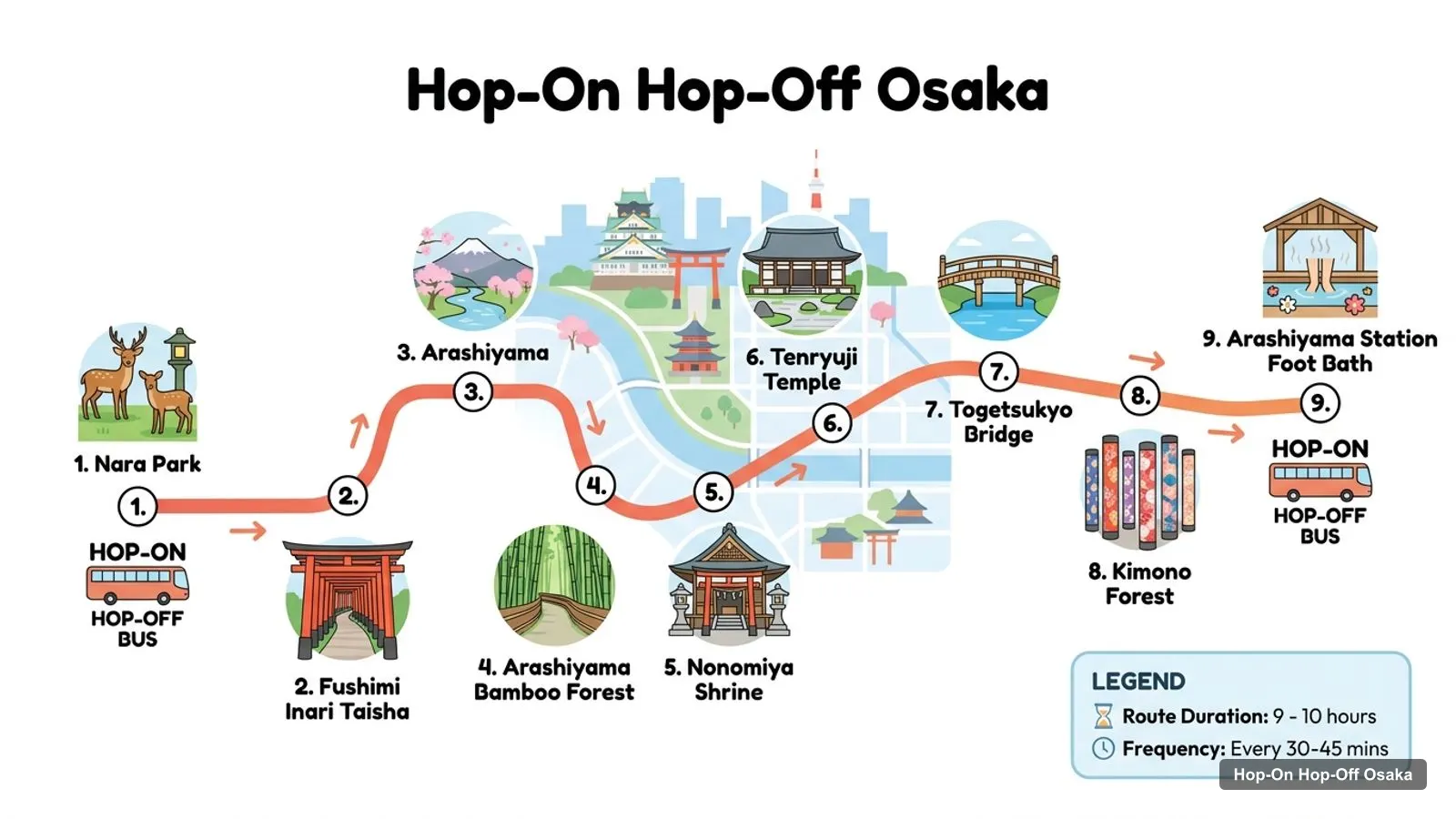
Stops on the route
| # | Stop on the Japan Visionary Tour | Area | Map |
|---|---|---|---|
| 1 | Nara Park | Nara | Search on Google Maps |
| 2 | Fushimi Inari Taisha | Kyoto, Fushimi | Search on Google Maps |
| 3 | Arashiyama | Kyoto, west | Search on Google Maps |
| 4 | Arashiyama Bamboo Forest | Arashiyama | Search on Google Maps |
| 5 | Nonomiya Shrine | Arashiyama | Search on Google Maps |
| 6 | Tenryuji Temple | Arashiyama | Search on Google Maps |
| 7 | Togetsukyo Bridge | Arashiyama | Search on Google Maps |
| 8 | Kimono Forest | Arashiyama | Search on Google Maps |
| 9 | Arashiyama Station Foot Bath | Arashiyama | Search on Google Maps |
The Nara, Fushimi Inari and Arashiyama stops are all outside Osaka. Osaka and Kyoto are about 44 km apart in a straight line, so the coach spends hours on the road. The tour leaves Osaka at 8:00 or Kyoto at 9:00 and takes 9 to 10 hours.
The Osaka tour map for the other three coach tours is shorter to describe. The VIP Japan Tour visits the same three destinations in the opposite order: Arashiyama, Nara Park, then Fushimi Inari Taisha. The LIMON Tours trip visits Fushimi Inari Taisha, Arashiyama, Kinkaku-ji and Kiyomizu-dera, with entry tickets for the last two included.
The fourth tour, to Naoshima Island, goes west by Shinkansen, coach and ferry from Uno Port. It is covered on my Kyoto-based Naoshima page. None of the four makes a stop inside Osaka, which is why the top-20 table below has no bus stops.
This Osaka tourism map lists the 20 most-reviewed places in my data, with the straight-line distance from Osaka Station City. Coordinates are in decimal degrees, and the link opens the place in Google Maps. I built the table from the data file with a script, not by hand, and I left out bus stops and tour agencies.
| # | Attraction | Rating (reviews) | Lat, Lng | km from Osaka Station City | Map |
|---|---|---|---|---|---|
| 1 | Osaka Castle | 4.4 (100,688) | 34.6873, 135.5259 | 3.2 | Map |
| 2 | Dotonbori | 4.4 (86,555) | 34.6687, 135.5013 | 3.8 | Map |
| 3 | Osaka Aquarium Kaiyukan | 4.5 (61,995) | 34.6545, 135.4290 | 8.1 | Map |
| 4 | Abeno Harukas | 4.2 (54,164) | 34.6461, 135.5135 | 6.5 | Map |
| 5 | Osaka Castle Park | 4.4 (52,134) | 34.6865, 135.5262 | 3.3 | Map |
| 6 | Tsutenkaku | 4.1 (43,861) | 34.6525, 135.5063 | 5.6 | Map |
| 7 | Umeda Sky Building | 4.4 (43,852) | 34.7053, 135.4897 | 0.7 | Map |
| 8 | Kuromon Market | 4.1 (21,143) | 34.6654, 135.5062 | 4.2 | Map |
| 9 | Glico Sign Dotonbori | 4.5 (19,705) | 34.6689, 135.5011 | 3.8 | Map |
| 10 | Kuchu Teien Observatory | 4.4 (14,296) | 34.7054, 135.4903 | 0.6 | Map |
| 11 | Tempozan Ferris Wheel | 4.5 (10,930) | 34.6563, 135.4310 | 7.8 | Map |
| 12 | Shinsekai | 4.2 (10,799) | 34.6516, 135.5060 | 5.7 | Map |
| 13 | Osaka Museum of History | 4.2 (7,206) | 34.6826, 135.5208 | 3.2 | Map |
| 14 | Nakanoshima Museum of Art, Osaka (NAKKA) | 4.4 (6,550) | 34.6924, 135.4914 | 1.2 | Map |
| 15 | Nakanoshima Park | 4.2 (6,500) | 34.6928, 135.5071 | 1.5 | Map |
| 16 | Osaka Castle Museum | 4.5 (5,881) | 34.6873, 135.5259 | 3.2 | Map |
| 17 | Osaka City Museum of Fine Arts | 4.1 (5,466) | 34.6501, 135.5104 | 6.0 | Map |
| 18 | Ebisu Bridge | 4.3 (5,066) | 34.6691, 135.5013 | 3.7 | Map |
| 19 | Hozen-ji | 4.4 (4,594) | 34.6679, 135.5025 | 3.9 | Map |
| 20 | Kids Plaza Osaka | 4.4 (4,519) | 34.7046, 135.5104 | 1.3 | Map |
Osaka Castle and Osaka Castle Park share a site, and the Osaka Castle Museum sits in the same grounds with the same coordinates, so the table counts the castle area three times. Dotonbori, the Glico Sign, Ebisu Bridge and Hozen-ji are within a few hundred metres of each other.
The Osaka travel map breaks into five clusters, and I’d plan a half day for each.
Two outliers sit further out. The Osaka Museum of Natural History and teamLab Botanical Garden Osaka are both in Nagai Park, about 10.5 km from Osaka Station City.
I don’t reproduce a rail map here because lines and station names change, and Osaka Metro publishes its own on its English site. What I can do is give you the numbers that decide which station you need. The distance column in the top-20 table is a ranking, not a journey time, and a sight at 3.2 km can take longer than one at 3.8 km if the route needs a transfer.
Osaka Metro fares depend on the shortest-route distance in sections, and the English page doesn’t print a yen amount, so I give none. It does say that transfers between subways and buses get an automatic discount of 100 yen for adults. Check the fare tool before you buy.
The map looks compact on a screen, but straight-line distances understate real walking. Osaka Station City to the aquarium is about 8.1 km as the crow flies, so that leg needs a train. Walking works inside a cluster: Kuromon Market to Dotonbori is about 0.6 km, and the museums on Nakanoshima are about 100 m apart.
For every sight more than about 1.5 km from where you are, I’d take the metro and keep walking for the clusters. Always open the Google Maps link first, because it routes along the streets, which a straight line can’t.
The ratings come from Google Maps. A high rating with few reviews tells you less than a high rating with many. The Osaka Ukiyoe Museum is rated 4.6, but from 519 reviews, while Osaka Castle is 4.4 from 100,688. I rank by review count for that reason, and I use the rating only to separate sights with similar counts.
Opening days matter more than ratings on this map. Google lists the Osaka Museum of History, the Science Museum, the National Museum of Art and Kids Plaza Osaka as closed on Tuesdays. Dotonbori, Shinsekai and the castle park are open 24 hours. My Osaka itinerary uses those hours to order the days.
There is no single official PDF I can point to from my data. The Osaka tourist information site is the official source for guidebooks and events, and Osaka Metro covers rail. For a printable version of my own, print this page, or save the Google Maps links to a list on your phone.
For a map PDF, I’d skip the paper and download an offline area in a map app, then star the places from the tables above. The names in my tables match Google Maps, so a search will find them even without data. Then add the day trip meeting points once you have booked, because the exact spot depends on the option you choose.
None of the four tours covers the Osaka sights, because they all leave the city, and my Osaka bus tour comparison explains the choice. The Nara and Arashiyama tour covers the most stops on the numbered map, nine in all, for $51.38. The LIMON Tours trip covers four sights and includes two entry tickets, from $40.47.
For the sights inside Osaka, see the best things to do in Osaka, and for my other city maps head to the homepage.
Japan Visionary Tour
My pick: Covers the most stops on this map: nine in one day, with a live guide, from $51.38.
This page works as one. The tables list the top 20 attractions with coordinates and a Google Maps link, and the stops of the longest bus day trip. Print the page, or open any Google Maps link and save the place to your phone for offline use. The Osaka tourist information site also publishes guides.
In five rough groups. Umeda and Nakanoshima are in the north, the castle area is north-east, Dotonbori and Kuromon Market are in the Minami centre, Shinsekai and Abeno Harukas are to the south, and the aquarium and Ferris wheel are on the bay to the west. Each group suits one half day.
From Osaka Station City, straight-line distances are about 0.7 km to the Umeda Sky Building, 3.2 km to Osaka Castle, 3.8 km to Dotonbori, 5.6 km to Tsutenkaku and 8.1 km to the Osaka Aquarium Kaiyukan. Real routes are longer, so check a map app for the journey.
I couldn't find a hop-on hop-off bus for Osaka in my data, so I don't have an operator route map. The only bus routes I can show are the stops of the coach day trips. The numbered image is for the Nara, Fushimi Inari and Arashiyama tour, which leaves Osaka at 8:00.
Osaka Metro publishes its network map and a fare tool on its English site, subway.osakametro.co.jp/en. I don't copy rail maps because they change, but my tables give each sight's coordinates so you can find the nearest station in a map app.
My full review of each one, in the order I rank them: