Historic Tours of America - Nashville
Nashville: Hop-on Hop-off Trolley Tour
- 4.6 (1,883 reviews)
- 2-day ticket
- Free cancellation
My pick: Covers every stop on this map: 13 stops, a live guide and 1 or 2 days, from $53.72.
By Jake Dawson · Updated · Affiliate links, explained in my disclosure
Historic Tours of America - Nashville
Nashville: Hop-on Hop-off Trolley Tour
4.6 (1,883) · from $53.72
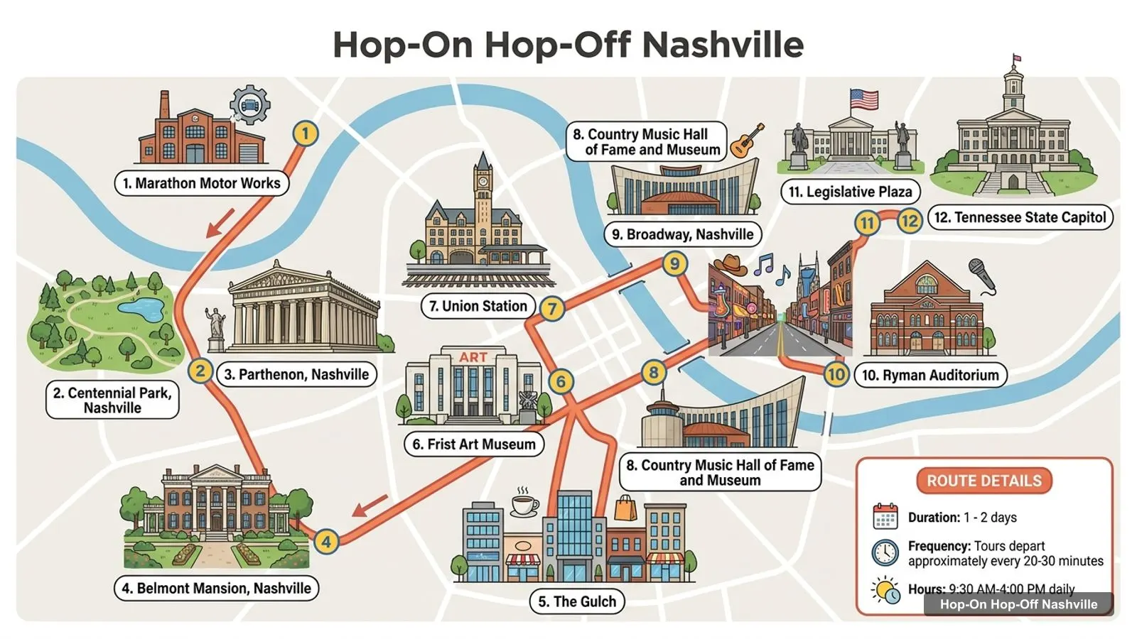
A Nashville tourist map makes sense once you see the city as a tight downtown cluster with a ring of big sights around it. I’ve put the top 20 attractions, ranked by Google Maps reviews, and all 13 Old Town Trolley stops on one page, with coordinates and a Google Maps link for each. The route image follows the trolley loop. To pick the ticket that rides it, see my comparison of hop-on hop-off in Nashville.
The Nashville sightseeing map below shows the Old Town Trolley loop. It starts at Marathon Motor Works, runs west to Centennial Park and the Parthenon, then east through the Gulch to Broadway, the Ryman and the Capitol. The loop is 11 miles and takes about 1 hour 50 minutes. Trolleys leave each stop every 20 to 30 minutes, and the listing gives hours of 9:30am to 4pm daily.
Stops on the route
| # | Stop | Address on the listing | Map |
|---|---|---|---|
| 1 | Marathon Motor Works | 1200 Clinton St | Find on Google Maps |
| 2 | Centennial Park / The Parthenon | 27th Ave N | Find on Google Maps |
| 3 | Hot Chicken | 1901 Broadway | Find on Google Maps |
| 4 | Belmont Mansion | 1900 Belmont Blvd | Find on Google Maps |
| 5 | The Gulch | 404 12th Ave S | Find on Google Maps |
| 6 | Frist Art Museum / Union Station Hotel | 1037 Broadway | Find on Google Maps |
| 7 | Country Music Hall of Fame | 472 Demonbreun St | Find on Google Maps |
| 8 | Live Music Bars | 201 Broadway | Find on Google Maps |
| 9 | Ryman Auditorium | 116 Rep. John Lewis Way | Find on Google Maps |
| 10 | Legislative Plaza / State Capitol | 6th and Deadrick | Find on Google Maps |
| 11 | Musicians Hall of Fame | 401 Gay St | Find on Google Maps |
| 12 | Farmers’ Market | 7th Ave N | Find on Google Maps |
| 13 | Capitol View | 1018 Nelson Merry St | Find on Google Maps |
The route image numbers stops 1 to 12. Stop 13, Capitol View on Nelson Merry Street, is the last on the listing. The listing says you can board at any stop, and Stop 1 has paid parking if you drive in.
These are the top Nashville tourist attractions in table form, ranked by Google Maps reviews, with exact coordinates. I left out tour companies, souvenir shops and offices that show up in Google Maps results. Each link opens the place in Google Maps, where you can save it to a list before you travel.
| # | Attraction | Coordinates | Google rating | Map |
|---|---|---|---|---|
| 1 | Grand Ole Opry | 36.20686, -86.69211 | 4.8 (33,339) | Open in Google Maps |
| 2 | Nashville Zoo at Grassmere | 36.08950, -86.74247 | 4.5 (21,714) | Open in Google Maps |
| 3 | Ryman Auditorium | 36.16125, -86.77847 | 4.8 (21,389) | Open in Google Maps |
| 4 | Country Music Hall of Fame and Museum | 36.15826, -86.77613 | 4.6 (20,624) | Open in Google Maps |
| 5 | Centennial Park | 36.14895, -86.81275 | 4.7 (15,701) | Open in Google Maps |
| 6 | The Parthenon | 36.14967, -86.81335 | 4.6 (15,446) | Open in Google Maps |
| 7 | Johnny Cash Museum | 36.16094, -86.77576 | 4.6 (11,447) | Open in Google Maps |
| 8 | Honky Tonk Highway | 36.16039, -86.77843 | 4.7 (7,787) | Open in Google Maps |
| 9 | Adventure Science Center | 36.14661, -86.77548 | 4.5 (6,306) | Open in Google Maps |
| 10 | Cheekwood | 36.08845, -86.87597 | 4.7 (6,176) | Open in Google Maps |
| 11 | Andrew Jackson’s Hermitage | 36.21387, -86.61620 | 4.7 (6,032) | Open in Google Maps |
| 12 | Cooter’s Nashville | 36.21770, -86.69786 | 4.6 (5,313) | Open in Google Maps |
| 13 | Frist Art Museum | 36.15790, -86.78385 | 4.6 (4,797) | Open in Google Maps |
| 14 | Bicentennial Capitol Mall State Park | 36.17089, -86.78759 | 4.7 (4,275) | Open in Google Maps |
| 15 | Radnor Lake State Park | 36.06309, -86.80965 | 4.7 (4,116) | Open in Google Maps |
| 16 | Tennessee State Museum | 36.17248, -86.79009 | 4.8 (3,981) | Open in Google Maps |
| 17 | Lane Motor Museum | 36.14020, -86.73458 | 4.8 (3,670) | Open in Google Maps |
| 18 | Madame Tussauds Nashville | 36.20484, -86.69405 | 4.5 (3,604) | Open in Google Maps |
| 19 | Belle Meade Historic Site & Winery | 36.10492, -86.86470 | 4.6 (3,368) | Open in Google Maps |
| 20 | John Seigenthaler Pedestrian Bridge | 36.16200, -86.77247 | 4.7 (3,195) | Open in Google Maps |
Two notes on the table. The Grand Ole Opry, the Zoo, Cheekwood and the Hermitage are well outside downtown, about 9.3 km, 8.6 km, 11.9 km and 15.7 km from the Ryman, so they need a car or rideshare. And check the weekday: Google Maps lists the Frist and the Adventure Science Center as closed on Tuesdays and Wednesdays.
On a Nashville Tn map downtown looks small, and it is. Most of the top 20 fall into four groups, and I’d plan by group rather than by sight.
Broadway and the river. The Ryman Auditorium, the Honky Tonk Highway, the Johnny Cash Museum, the Country Music Hall of Fame, the National Museum of African American Music and the John Seigenthaler Pedestrian Bridge are all within about 550 metres of the Ryman. Trolley Stops 7, 8 and 9 serve them. This is the cluster to walk.
The West End. Centennial Park and the Parthenon share Stop 2 and sit about 3.4 km from the Ryman. Belmont Mansion (Stop 4) is about 2.2 km from the park. Historic RCA Studio B is about 1.8 km from Centennial Park.
The Capitol side. The Tennessee State Capitol is about 720 metres from the Ryman, with Bicentennial Capitol Mall State Park below it, rated 4.7. The Tennessee State Museum is about 290 metres from the park, and the Musicians Hall of Fame (Stop 11) is about 810 metres from the Ryman. Stops 10, 11 and 12 serve this side.
The outer ring. The Opry, Madame Tussauds and Cooter’s Nashville are around Opry Mills, with Madame Tussauds about 280 metres from the Opry. The Zoo, Cheekwood, Belle Meade and Radnor Lake are south and west. None is on the trolley route.
The trolley reaches 5 of the top 15 by reviews. Those are the Ryman (Stop 9), the Country Music Hall of Fame (Stop 7), Centennial Park and the Parthenon (Stop 2), the Honky Tonk Highway (Stop 8) and the Frist Art Museum (Stop 6). The Johnny Cash Museum is not named on the stop list, but it is about 100 metres from Stop 8 at 201 Broadway.
That makes the trolley a good fit for the first two clusters and a poor fit for the outer ring. If you want the Opry or Cheekwood as well, plan a separate half day. My Nashville itinerary puts both halves into 1, 2 and 3-day plans.
Is Nashville worth visiting? Going by the map, yes, and the core is compact. The Grand Ole Opry alone has 33,339 Google reviews. The Ryman and the Tennessee State Museum are both rated 4.8, and the National Museum of African American Music is rated 4.9 from 2,163 reviews. Two days covers the downtown clusters, and a third day leaves room for the Opry and one outer sight.
What is Nashville famous for, judged by this map? Country music, first of all: the Opry, the Ryman, the Country Music Hall of Fame, the Johnny Cash Museum and the Musicians Hall of Fame are all in the places I pulled from Google Maps. After that come the Honky Tonk Highway on Broadway, the Parthenon replica in Centennial Park, and the Hermitage, the home of President Andrew Jackson. For events and shows, Visit Music City is the official tourism calendar.
If you want a printable Nashville tourist map, print this page: the route image and the two tables fit on a few sheets and keep the stop numbers next to the sights. For a PDF, use your browser’s Print to PDF option, which keeps the Google Maps links clickable on a phone or tablet. I’d also save the 20 attractions to a starred list in Google Maps. It takes a couple of minutes with the links above, and the list works offline once you download the downtown area.
If you’d rather walk part of the Nashville tourist map, Broadway is the easy stretch. From the Ryman, the Honky Tonk Highway is about 100 metres, the Country Music Hall of Fame about 390 metres and Fort Nashborough about 430 metres. The pedestrian bridge is about 540 metres and the Public Square Park about 600 metres. The West End is the part I wouldn’t walk: Centennial Park is about 3.4 km from the Ryman, which is where the trolley earns its fare.
The Old Town Trolley on GetYourGuide covers the 13-stop route on this map, from $53.72 with a live guide. The other Nashville ticket is the Music City Brew Hop, a $45 day pass for a seven-brewery loop in East Nashville that doesn’t follow this route. If you want the sightseeing option I’d book, it’s in my Nashville trolley comparison, and the rest of my city maps start from the homepage. For ratings and addresses of each sight, see my list of the best things to do in Nashville.
Historic Tours of America - Nashville
My pick: Covers every stop on this map: 13 stops, a live guide and 1 or 2 days, from $53.72.
This page works as one. The route image shows the trolley loop with numbered stops, and the tables list all 13 stops and the top 20 attractions with coordinates. Print the page, or open the Google Maps links to save the places to your phone so they work offline.
In three downtown clusters and one outer ring. Broadway and the river have the Ryman, the Country Music Hall of Fame and the Johnny Cash Museum. The West End has Centennial Park and the Parthenon. The Capitol side has the State Museum and Bicentennial Mall. The Opry, the Zoo and Cheekwood sit 8 km or more out.
Downtown they are very close: the Ryman is about 100 metres from the Honky Tonk Highway, 250 metres from the Johnny Cash Museum and 390 metres from the Country Music Hall of Fame. Centennial Park is about 3.4 km from the Ryman, and the Grand Ole Opry about 9.3 km, measured from Google Maps coordinates.
Yes. Lower Broadway is a short walk from the Ryman, and the Honky Tonk Highway is listed on Google Maps from 10am to 3am. The Country Music Hall of Fame and the Johnny Cash Museum are within about 400 metres. The trolley's Live Music Bars stop at 201 Broadway drops you at the river end.
My full review of each one, in the order I rank them: