
Sightseeing Experience
City Sightseeing Napoli Hop On Hop Off Tour 24h
- 4.3 (6,323 reviews)
- 24-hour ticket
- Free cancellation
My pick: The ticket that covers this whole map: both lines for $30.40, 4.33 from 6,323 reviews.
By Jake Dawson · Updated · Affiliate links, explained in my disclosure
Sightseeing Experience
City Sightseeing Napoli Hop On Hop Off Tour 24h
4.3 (6,323) · from $30.40

A Naples tourist map is easiest to use when you see the city as a few areas rather than one sprawling grid. On this page I put the sightseeing bus stops and the main sights in one place, with a Google Maps link for each. For ticket prices and what is included, my hop-on hop-off Naples guide has the comparison. The route data here comes from the City Sightseeing Napoli listing, so the stop order is exact.
The stop table uses Google Maps search links, and the top-20 attraction table below gives ratings, review counts and coordinates from my places data.
The Naples sights map below shows the numbered stops in the order the operator lists them. There are two lines. Line A is the historic loop with nine stops, and a full circuit takes about 45 minutes. Line B is the panoramic loop with eleven stops, and a full circuit takes about 70 minutes. Both start at Stop 1, Largo Castello in Piazza Municipio, which the operator describes as adjacent to Castel Nuovo. The meeting point coordinates in the listing are 40.8382, 14.2517.
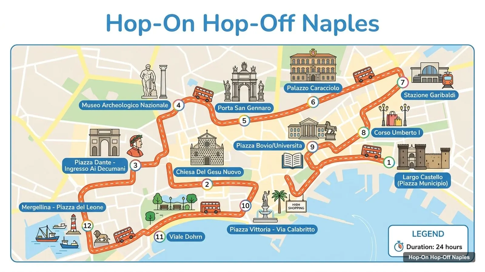
Stops on the route
The first nine rows are Line A. Rows ten to twelve are the first stops of Line B after the shared Stop 1.
| # | Stop | Line | Map |
|---|---|---|---|
| 1 | Largo Castello (Piazza Municipio) | A+B | Open in Google Maps |
| 2 | Chiesa Del Gesu Nuovo | A | Open in Google Maps |
| 3 | Piazza Dante - Ingresso Ai Decumani | A | Open in Google Maps |
| 4 | Museo Archeologico Nazionale | A | Open in Google Maps |
| 5 | Porta San Gennaro | A | Open in Google Maps |
| 6 | Palazzo Caracciolo | A | Open in Google Maps |
| 7 | Stazione Garibaldi | A | Open in Google Maps |
| 8 | Corso Umberto I | A | Open in Google Maps |
| 9 | Piazza Bovio/Universita | A | Open in Google Maps |
| 10 | Piazza Vittoria - Via Calabritto | B | Open in Google Maps |
| 11 | Viale Dohrn | B | Open in Google Maps |
| 12 | Mergellina - Piazza del Leone | B | Open in Google Maps |
Line B continues past Mergellina to Capo Posillipo (a panoramic viewpoint), Posillipo, Parco Virgiliano, Via Petrarca, Piazza Vittoria, Chiatamone, and finally Via Acton at Porto Stazione Marittima, which the operator describes as the pier for cruises and the Gulf islands. The last stop is the one to use if you arrive by ship.
The table below places the main sights by area and shows which bus stop is nearest, where there is one. Where the listing does not name a stop, I say it is a walk from Stop 1 instead of inventing a stop. Open the Google Maps links to check the exact distance from where you are.
| Sight | Area | Nearest bus stop | Map |
|---|---|---|---|
| Castel Nuovo | Old centre and harbour | Stop 1, both lines | Open in Google Maps |
| Piazza del Plebiscito | Old centre and harbour | Short walk from Stop 1 | Open in Google Maps |
| Royal Palace of Naples | Old centre and harbour | Short walk from Stop 1 | Open in Google Maps |
| Teatro San Carlo | Old centre and harbour | Short walk from Stop 1 | Open in Google Maps |
| Via Toledo | Old centre and harbour | Walk from Stop 1 | Open in Google Maps |
| Quartieri Spagnoli (Spanish Quarter) | Old centre and harbour | Walk from Stop 1 | Open in Google Maps |
| Chiesa del Gesu Nuovo | Historic centre | Line A Stop 2 | Open in Google Maps |
| Piazza Dante | Historic centre | Line A Stop 3 | Open in Google Maps |
| Decumani (Spaccanapoli) | Historic centre | Line A Stop 3 | Open in Google Maps |
| Museo Archeologico Nazionale | Historic centre | Line A Stop 4 | Open in Google Maps |
| Porta San Gennaro | Historic centre | Line A Stop 5 | Open in Google Maps |
| Stazione Napoli Centrale / Garibaldi | Station area | Line A Stop 7 | Open in Google Maps |
| Castel dell’Ovo | Seafront | Line B, Chiatamone stop is nearest named | Open in Google Maps |
| Mergellina | Seafront and Posillipo | Line B Stop 4 | Open in Google Maps |
| Parco Virgiliano | Seafront and Posillipo | Line B Stop 7 | Open in Google Maps |
| Molo Beverello ferry port | Harbour | Near Stop 1 | Open in Google Maps |
| Funicolare Centrale, Augusteo station | Vomero hill | Meeting point of the guided walk | Open in Google Maps |
| Vomero panoramic terrace | Vomero hill | Reached by funicular | Open in Google Maps |
These are the most-reviewed Naples sights on Google Maps, skipping bus operators and places far outside the centre. Each row has the coordinates and a Google Maps link.
| # | Attraction | Rating | Reviews | Latitude | Longitude | Map |
|---|---|---|---|---|---|---|
| 1 | Piazza del Plebiscito | 4.7 | 91,558 | 40.8358 | 14.2486 | Open in Google Maps |
| 2 | Sansevero Chapel Museum | 4.7 | 44,437 | 40.8493 | 14.2549 | Open in Google Maps |
| 3 | Museo Archeologico Nazionale di Napoli | 4.6 | 37,920 | 40.8536 | 14.2505 | Open in Google Maps |
| 4 | Castel Sant’Elmo | 4.6 | 36,765 | 40.8445 | 14.2389 | Open in Google Maps |
| 5 | Castel Nuovo | 4.4 | 36,330 | 40.8385 | 14.2527 | Open in Google Maps |
| 6 | Underground Naples | 4.5 | 32,333 | 40.8511 | 14.2568 | Open in Google Maps |
| 7 | Capodimonte Museum | 4.6 | 28,674 | 40.8670 | 14.2507 | Open in Google Maps |
| 8 | Cathedral of Santa Maria Assunta | 4.7 | 27,213 | 40.8525 | 14.2593 | Open in Google Maps |
| 9 | Complesso Monumentale di Santa Chiara | 4.7 | 19,138 | 40.8472 | 14.2526 | Open in Google Maps |
| 10 | Galleria Umberto I | 4.6 | 15,186 | 40.8385 | 14.2495 | Open in Google Maps |
| 11 | Catacombs of San Gennaro | 4.7 | 13,728 | 40.8651 | 14.2474 | Open in Google Maps |
| 12 | Royal Palace of Naples | 4.6 | 11,381 | 40.8362 | 14.2494 | Open in Google Maps |
| 13 | Charterhouse & Museum of San Martino | 4.5 | 6,851 | 40.8436 | 14.2408 | Open in Google Maps |
| 14 | Royal Chapel of the Treasure of San Gennaro | 4.8 | 5,741 | 40.8524 | 14.2597 | Open in Google Maps |
| 15 | Galleria Borbonica | 4.8 | 4,806 | 40.8329 | 14.2434 | Open in Google Maps |
| 16 | Piazza Vincenzo Bellini | 4.4 | 4,610 | 40.8500 | 14.2521 | Open in Google Maps |
| 17 | Belvedere San Martino | 4.7 | 4,400 | 40.8441 | 14.2408 | Open in Google Maps |
| 18 | Monumental Complex of Saint Anne of the Lombards | 4.8 | 4,093 | 40.8449 | 14.2505 | Open in Google Maps |
| 19 | Palazzo Zevallos Stigliano | 4.6 | 3,885 | 40.8398 | 14.2486 | Open in Google Maps |
| 20 | Donnaregina Contemporary Art Museum - Madre Museum | 4.2 | 3,743 | 40.8552 | 14.2585 | Open in Google Maps |
Old centre and harbour. This is where both bus lines begin. Castel Nuovo, Piazza del Plebiscito, the Royal Palace, Teatro San Carlo and the start of Via Toledo are all close together, and the Molo Beverello ferry port is in the same area. If you arrive by ferry, you are already at the map’s starting point.
Historic centre. Line A runs north from Stop 1 through Chiesa del Gesu Nuovo, Piazza Dante and the Decumani, then to the Museo Archeologico Nazionale and Porta San Gennaro. This is the densest part of the map, and it works best on foot between stops.
Seafront and Posillipo. Line B is the coastal route. It passes Piazza Vittoria, Viale Dohrn and Mergellina, then climbs to Posillipo and Parco Virgiliano. These stops are far apart, so the bus matters most here.
Vomero. The hill above the centre is not on the bus lines. The guided walk at $45.04 uses the Funicolare Centrale, starting next to the Augusteo funicular station, and gives views of the gulf, Vesuvius and Capri according to the reviewers.
If this is your first time in the city, do not try to learn the whole map at once. Learn three anchors. The first is Stop 1 at Castel Nuovo, where both bus lines begin and where the ferry port is nearby. The second is Piazza Dante, the gateway to the Decumani and the best single place to get lost on foot. The third is Mergellina, the point where the old city gives way to the coast. Everything else on the map can be reached from one of those three by bus.
I would also decide the order before you leave the hotel. Ride Line A first if you like museums and old streets, and Line B first if the sky is clear and you care about views. You can always swap, because one ticket covers both, but starting with the right line stops you spending the best light of the day inside a museum.
If your ship docks in the city, the key stop on this map is the last one on Line B, Via Acton at Porto Stazione Marittima, described by the operator as the pier for cruises and the Gulf islands. Stop 1 at Piazza Municipio is also in the same part of town. With only a few hours ashore, I would ride Line A for the highlights, since a full loop takes about 45 minutes, and leave Line B for another visit. Keep a margin before all-aboard time, as one reviewer notes long queues when a ship is in.
If you want a short rule for using the map, it is this. For art and history, ride Line A and get off at Stop 3 for the Decumani and Stop 4 for the museum. For views, ride Line B to Parco Virgiliano. For the castle and the squares, stay at Stop 1 and walk. For trains, use the Stazione Garibaldi stop on Line A. For cruise ships, use the Via Acton stop on Line B.
For official local information on opening hours, events and transport, I would use the operators and city sources rather than a third-party map. The bus operator’s app, called Sightseeing Experience, shows an interactive map with live bus locations and the waiting time at each stop. For the city’s public transport, see ANM Napoli, and for general background on the city, Wikipedia’s Naples page is a decent start.
The bus has audio commentary in eight languages: Spanish, Chinese, English, French, German, Italian, Russian and Japanese. One reviewer says the Line A commentary could be better synchronised with the bus, so use the map as a backup when the audio and the view do not match.
I do not host a PDF of the Naples tourist map. This page is built to print instead: the route image, the stop table and the sights table all fit on a few sheets. If you prefer your phone, open any Google Maps link above and save it to a list. That works offline if you download the Naples area in Google Maps first.
Distances on the map look short but the old centre is hilly in places and crowded in summer. I’d walk between stops 1 to 3 on Line A, because the sights are close, and use the bus for the longer jumps, such as the museum to the seafront. Wear shoes you can walk in on cobblestones, and check the weather before you plan Posillipo, because the viewpoint is the whole reason to go.
The 24-hour City Sightseeing Napoli ticket covers both lines in this map, and costs $30.40 with 6,323 reviews averaging 4.33. The other four products I found add something around the bus: a guided walk, the Rome train, the Salerno train or the Capri ferry. For the full comparison, go to my Naples hop-on hop-off tickets guide.
Sightseeing Experience
My pick: The ticket that covers this whole map: both lines for $30.40, 4.33 from 6,323 reviews.
To see what to do at each stop, read my best things to do in Naples, and to turn the map into a schedule, use my Naples itinerary. For other cities, head back to the homepage.
This page works as one. The route image shows the sightseeing bus stops in order, and the tables list every stop and the main sights with a Google Maps link. Print the page, or open the links and save the places to your phone for offline use. The bus app also shows live bus positions and waiting times.
In four areas. The old centre and harbour has Castel Nuovo and Piazza del Plebiscito. The historic centre has the Decumani, Gesu Nuovo and the archaeological museum. The seafront runs from Castel dell'Ovo to Mergellina, and the Posillipo hill has the Parco Virgiliano viewpoint. Vomero sits on the hill above the centre.
Both lines start at Stop 1, Largo Castello in Piazza Municipio, outside Castel Nuovo. The operator's meeting point coordinates are 40.8382, 14.2517. You can hop on at any other stop, so Stazione Garibaldi works if you arrive by train, and the cruise pier stop on Via Acton works if you arrive by ship.
Line A covers the dense historic centre with nine stops in about 45 minutes. Line B covers the coast and the Posillipo hill with eleven stops in about 70 minutes. Both start at Stop 1. The 24-hour ticket at $30.40 includes both lines, so the question is mostly which one to ride first.
My full review of each one, in the order I rank them: