Munich Tourist Map: Top Attractions & Bus Stops
By Jake Dawson · Updated · Affiliate links, explained in my disclosure
CitySightseeing München
Munich Hop-On Hop-Off Tour: 1-Day or 2-Day Ticket
4.3 (4,782) · from $27.59
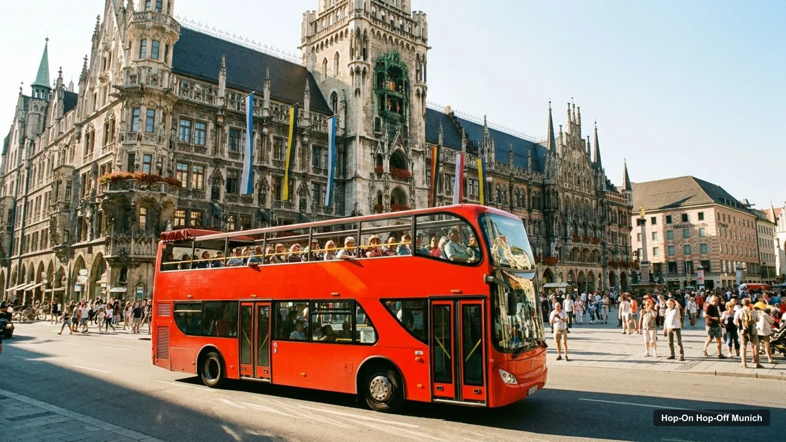
A Munich tourist map makes sense once you see the city as one compact centre with two arms. I’ve put the top 20 attractions, ranked by Google Maps reviews, and the sightseeing bus stops on one page, with coordinates and a Google Maps link for each. This Munich tourist map follows the Big Bus stop list for the route image, the only one on GetYourGuide with every stop named in order. To pick the ticket that rides it, see my comparison of hop-on hop-off in Munich.
All distances on this page are straight lines measured from the Google Maps coordinates, so expect to walk a little further. Ratings and review counts come from Google Maps, checked October 2026.
Munich Sightseeing Map: The Bus Route
The Munich sightseeing map below shows the 10 stops of the Big Bus route, from Karlsplatz through the Old Town and out to Nymphenburg Palace, the Olympic Park and Schwabing. The Green Line covers the centre and runs every 20 minutes for a 60-minute loop. The Orange Line covers the outer stops and runs every 30 minutes on weekdays and every 20 minutes at weekends, for an 80-minute loop. If you stay on board, the full route takes about 2.5 hours.
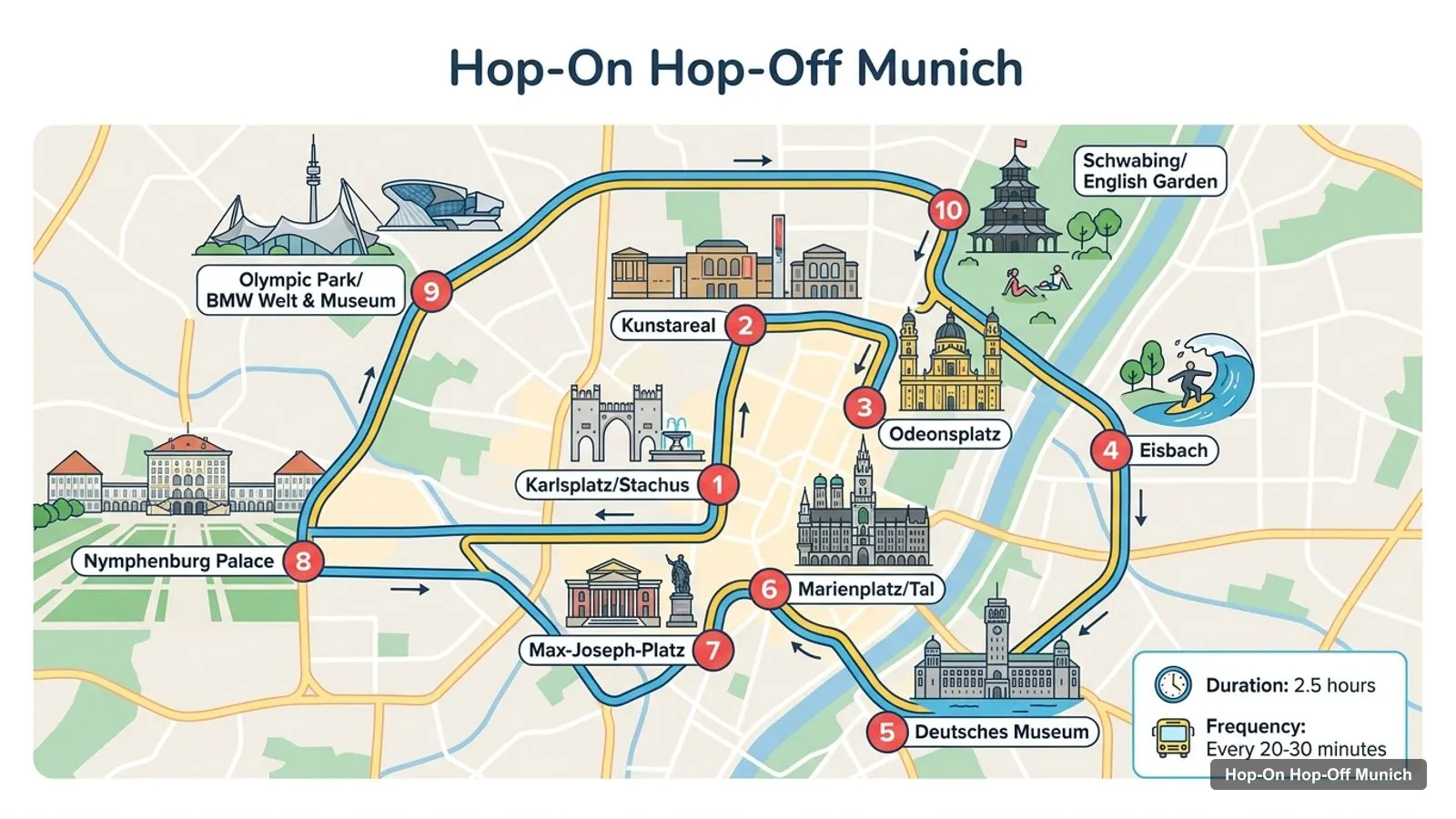
Stops on the route
- 1Karlsplatz/Stachus
- 2Kunstareal
- 3Odeonsplatz
- 4Eisbach
- 5Deutsches Museum
- 6Marienplatz/Tal
- 7Max-Joseph-Platz
- 8Nymphenburg Palace
- 9Olympic Park/BMW Welt & Museum
- 10Schwabing/English Garden
Bus stops on the route
| # | Stop | Map |
|---|---|---|
| 1 | Karlsplatz/Stachus | Find on Google Maps |
| 2 | Kunstareal | Find on Google Maps |
| 3 | Odeonsplatz | Find on Google Maps |
| 4 | Eisbach | Find on Google Maps |
| 5 | Deutsches Museum | Find on Google Maps |
| 6 | Marienplatz/Tal | Find on Google Maps |
| 7 | Max-Joseph-Platz | Find on Google Maps |
| 8 | Nymphenburg Palace | Find on Google Maps |
| 9 | Olympic Park/BMW Welt & Museum | Find on Google Maps |
| 10 | Schwabing/English Garden | Find on Google Maps |
Two notes on the stops shown on this Munich tourist map. The Deutsches Museum stop is temporarily suspended because of construction work, per the Big Bus listing. The listing’s own numbering also skips around, with the Olympic Park counted as stops 9 and 10, so the numbers on the bus may not match the table. CitySightseeing runs three one-hour routes with 13 stops in total, from its central station at Luisenstraße 4. It doesn’t publish the stop names on GetYourGuide, but its routes pass the same sights: Marienplatz, Odeonsplatz, the Old Town, Nymphenburg Palace, the Olympic Park and the English Garden.
Munich Tourist Attractions Map: Top 20 Sights with Coordinates
This is the Munich tourist attractions map in table form, ranked by Google Maps reviews, with exact coordinates. Each link opens the place in Google Maps, where you can save it to a list before you travel. I’ve left out the tour company offices.
| # | Attraction | Coordinates | Google rating | Map |
|---|---|---|---|---|
| 1 | Marienplatz | 48.13739, 11.57545 | 4.7 (156,471) | Open in Google Maps |
| 2 | Hofbräuhaus München | 48.13764, 11.57975 | 4.3 (110,676) | Open in Google Maps |
| 3 | Olympiapark München | 48.17543, 11.55199 | 4.7 (80,623) | Open in Google Maps |
| 4 | English Garden | 48.16423, 11.60555 | 4.7 (69,681) | Open in Google Maps |
| 5 | Viktualienmarkt | 48.13539, 11.57608 | 4.6 (63,987) | Open in Google Maps |
| 6 | BMW Museum | 48.17683, 11.55910 | 4.6 (48,962) | Open in Google Maps |
| 7 | Deutsches Museum | 48.12987, 11.58345 | 4.5 (44,104) | Open in Google Maps |
| 8 | Nymphenburg Palace | 48.15827, 11.50331 | 4.6 (40,618) | Open in Google Maps |
| 9 | Karlsplatz (Stachus) | 48.13925, 11.56602 | 4.5 (30,749) | Open in Google Maps |
| 10 | Eisbachwelle (water waves) | 48.14348, 11.58773 | 4.8 (23,730) | Open in Google Maps |
| 11 | Munich Residence | 48.14180, 11.57949 | 4.6 (23,644) | Open in Google Maps |
| 12 | Odeonsplatz | 48.14205, 11.57740 | 4.6 (23,123) | Open in Google Maps |
| 13 | Frauenkirche | 48.13866, 11.57301 | 4.6 (15,766) | Open in Google Maps |
| 14 | Alte Pinakothek | 48.14833, 11.56998 | 4.7 (13,493) | Open in Google Maps |
| 15 | Isar Gate | 48.13511, 11.58184 | 4.5 (10,005) | Open in Google Maps |
| 16 | Königsplatz | 48.14571, 11.56528 | 4.6 (9,817) | Open in Google Maps |
| 17 | Pinakothek der Moderne | 48.14739, 11.57226 | 4.5 (9,780) | Open in Google Maps |
| 18 | Asamkirche | 48.13514, 11.56966 | 4.8 (7,152) | Open in Google Maps |
| 19 | St. Michael München | 48.13868, 11.57026 | 4.7 (6,179) | Open in Google Maps |
| 20 | German Transport Museum | 48.13260, 11.54208 | 4.6 (5,392) | Open in Google Maps |
Eleven of the top 15 sit on a bus route or right next to a stop. The full write-up of each one, with opening hours, is in my guide to the best things to do in Munich.
Munich Sites Map: The Four Clusters
The Munich sites map breaks into four clusters, and each one is a half day.
The Old Town around Marienplatz
Marienplatz is the centre of everything. The Frauenkirche and Viktualienmarkt are both about 230 metres away, the Hofbräuhaus about 320 metres, the Münchner Stadtmuseum about 350 metres, and the Asamkirche about 500 metres. Karlsplatz, the western gate, is about 730 metres down the pedestrian zone, with St. Michael about 320 metres from it. The Isar Gate is about 540 metres east along the Tal. Big Bus stops at Karlsplatz/Stachus and Marienplatz/Tal.
Odeonsplatz, the Residence and the Eisbach
North of Marienplatz, Odeonsplatz is about 540 metres away, with the Theatine Church about 60 metres from it and the Residence about 160 metres. Keep walking east for about 780 metres and you reach the Eisbach wave, with the House of Art about 140 metres from it. Big Bus stops at Odeonsplatz, Max-Joseph-Platz and the Eisbach.
The Kunstareal and Königsplatz
The museum quarter sits about 1 km north of Karlsplatz. The Alte Pinakothek and the Pinakothek der Moderne are about 200 metres apart, and Königsplatz with the Glyptothek is about 450 metres from the Alte Pinakothek. The Lenbachhaus is about 840 metres from Karlsplatz. Big Bus serves the whole quarter with its Kunstareal stop.
Nymphenburg and the Olympic Park
These are the two sights you shouldn’t try to walk to. Nymphenburg Palace is about 5.8 km west of Marienplatz, and the Olympic Park about 4.6 km north. The BMW Museum is about 550 metres from the park’s centre. The palace and the park are about 4.1 km apart, and both operators link them on the same route: CitySightseeing’s Nymphenburg-Olympia Tour and the Big Bus Orange Line.
Theresienwiese and the Transport Museum
A fifth, smaller cluster sits west of the Old Town. The German Transport Museum (4.6 from 5,392 reviews) is about 1.9 km from Karlsplatz, and the Bavaria Statue above the Theresienwiese, the Oktoberfest grounds, is about 360 metres from it. Neither is on a bus route, so take the U-Bahn or walk from Karlsplatz.
Top Sights That Aren’t Bus Stops
Six of the top 20 sights on this Munich tourist map sit in the Old Town without a stop of their own, but none is far from one. From the Marienplatz/Tal stop, Viktualienmarkt and the Frauenkirche are about 230 metres away, the Hofbräuhaus about 320 metres, the Asamkirche about 500 metres and the Isar Gate about 540 metres. From Karlsplatz/Stachus, St. Michael is about 320 metres down the pedestrian zone. That’s why I’d treat the Old Town as one long walk between two stops rather than hopping on and off every few hundred metres. Save the bus for the outer sights, where a stop saves you several kilometres.
How to Use This Munich Tourist Map on Your Phone
The easiest way to use this Munich tourist map is to open each Google Maps link before you travel and save the place to a list. Google Maps then shows all of them as pins, and they stay visible offline if you download the Munich area. I’d make two lists: one for the Old Town cluster, which you’ll walk, and one for the outer sights, which you’ll ride to. Add the bus stops from the first table to a third list, so you can see the nearest stop at a glance. On the bus, the Big Bus app shows live bus positions, which is the fastest way to see how long you’ll wait at a stop.
Munich Tourist Guide: Getting Between the Clusters
My Munich tourist guide rule is simple: walk inside a cluster, ride between clusters. The Old Town, Odeonsplatz and the Kunstareal are each within about 1.3 km of Marienplatz. Nymphenburg and the Olympic Park aren’t. For those, you have two options. A sightseeing bus links them with commentary, from $27.36 for 24 hours with Big Bus or $27.59 with CitySightseeing. Otherwise the U-Bahn, S-Bahn and trams of the MVV network cover them on a standard public transport ticket. In winter, check the bus times first: from 1 October, CitySightseeing’s Nymphenburg-Olympia Tour runs every hour on weekdays, with the last departure at 4pm.
Munich Tourist Information
For Munich tourist information, opening times and events, munich.travel is the city’s official tourism site. Both bus operators have a desk near the main station. CitySightseeing’s tours begin at its central station at Luisenstraße 4, which has 1,157 Google reviews averaging 4.3. Big Bus recommends Stop 1 at Karlsplatz 21, next to the Buddy Hotel, and the listing says to ask for “Münchener Stadtrundfahrten” if you can’t spot the blue buses. The two points are about 370 metres apart. For a day-by-day plan built on this Munich tourist map, see my Munich itinerary for 1, 2 and 3 days.
Which Ticket Rides This Map
Both bus tickets cover the clusters above, and I compare them stop by stop, with prices and timetables, in my guide to the Munich sightseeing bus. For more city maps, go back to the homepage.
Frequently asked questions
Is there a printable Munich tourist map?
This page works as one. The route map image shows the sightseeing bus loop with 10 numbered stops, and the tables below list the top 20 attractions with coordinates and the bus stops with Google Maps links. Print the page, or open the links to save the places to your phone for offline use.
Where are most Munich attractions on the map?
Most sit in the Old Town, within about 1.3 km of Marienplatz: the Frauenkirche, Viktualienmarkt, the Hofbräuhaus, the Residence, Odeonsplatz and the Kunstareal museums. The exceptions are Nymphenburg Palace, about 5.8 km west, and the Olympic Park and BMW Museum, about 4.6 km north.
How far apart are the main Munich sights?
Karlsplatz to Marienplatz is about 730 metres through the pedestrian zone, and Marienplatz to Odeonsplatz about 540 metres. Marienplatz to the Deutsches Museum is about 1 km. Nymphenburg Palace and the Olympic Park are about 4.1 km apart, which is where a bus or the U-Bahn saves the most time.
Where is the tourist information in Munich?
The city's official tourism site, munich.travel, lists the tourist information offices and opening times. Both sightseeing bus operators also have a desk near the main station: CitySightseeing at Luisenstraße 4 and Big Bus, sold as Münchener Stadtrundfahrten, at Karlsplatz 21.
Tours I compared in Munich
My full review of each one, in the order I rank them:
- Munich Hop-On Hop-Off Tour: 1-Day or 2-Day Ticket★ 4.3 · from $27.59
- Munich: Big Bus Hop-On Hop-Off Tour by Open-Top Bus★ 4.1 · from $27.36