Malaga Tourist Map: Top Attractions & Bus Stops
By Jake Dawson · Updated · Affiliate links, explained in my disclosure
City Sightseeing Europe
Malaga: City Sightseeing Hop-On Hop-Off Bus & Museum Entry
4.0 (3,040) · from $33.77
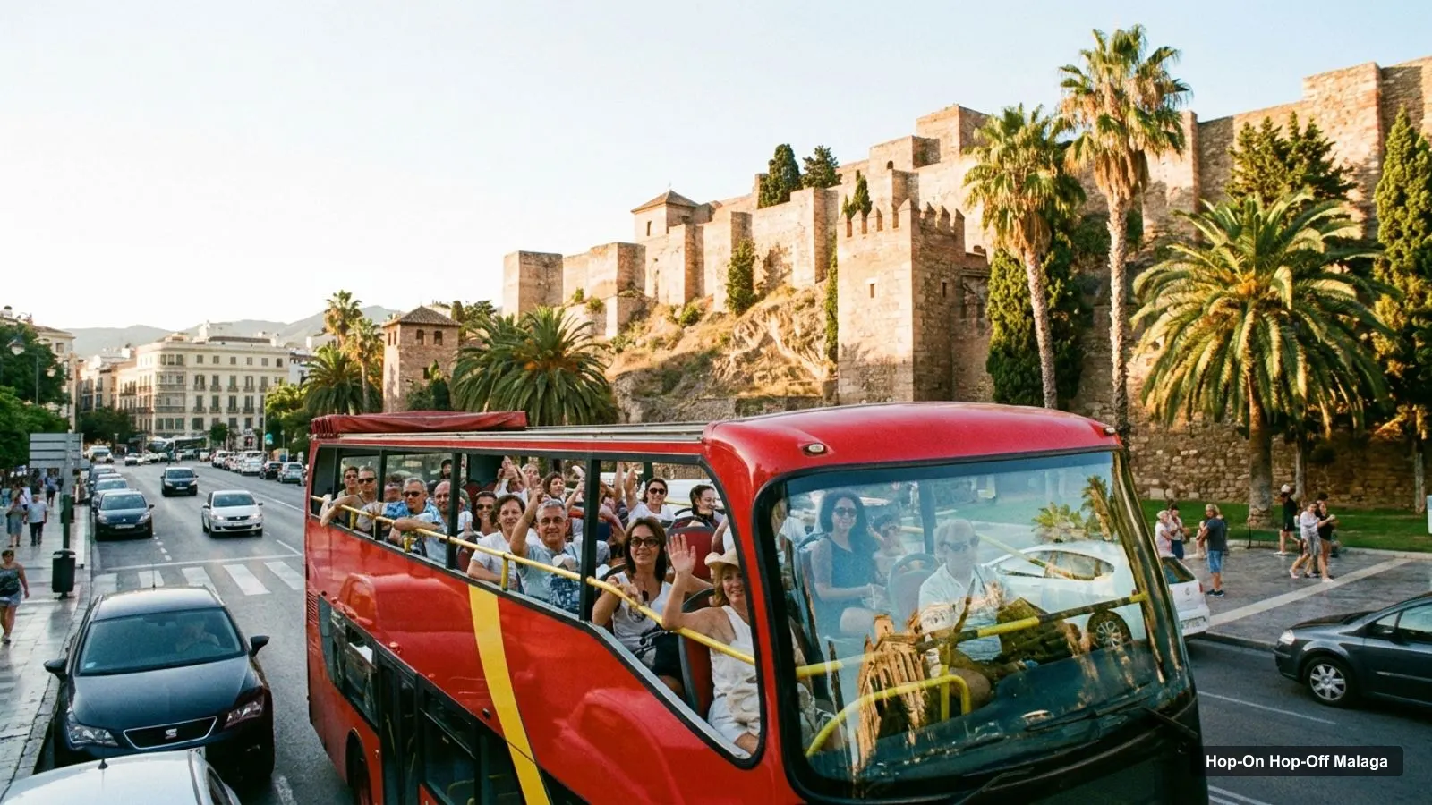
The Malaga tourist map below shows the City Sightseeing network: the 14-stop Red Route, the 5-stop Blue Route and the 13-stop Green Route, plus the 20 most-reviewed attractions in the city with coordinates and Google Maps links. To plan the bus ride itself, start with my guide to hop-on hop-off Malaga, which covers the price, the timetable and what the ticket includes.
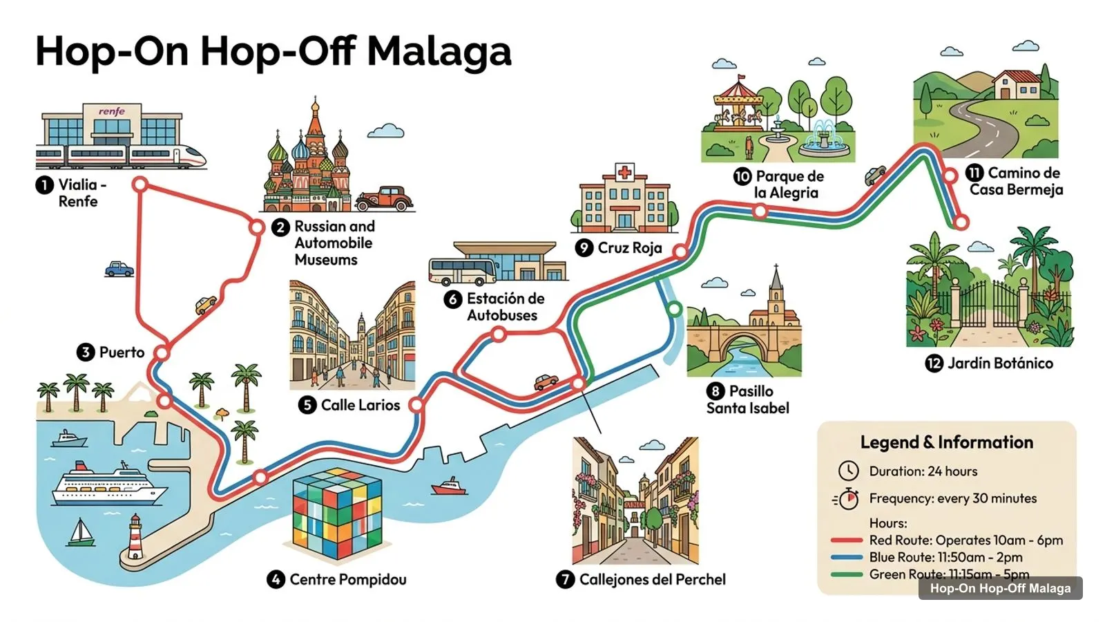
The Red Route runs 10am to 6pm every 30 minutes, with an 80-minute loop. The Blue Route runs 11:50am to 2pm every 50 minutes, and the Green Route 11:15am to 5pm every 75 minutes. The Green Route doesn’t run on Mondays. Everything here comes from the operator’s listing and from Google Maps coordinates.
Stops on the route
- 1Vialia - Renfe
- 2Russian and Automobile Museums
- 3Puerto
- 4Centre Pompidou
- 5Calle Larios
- 6Estación de Autobuses
- 7Callejones del Perchel
- 8Pasillo Santa Isabel
- 9Cruz Roja
- 10Parque de la Alegria
- 11Camino de Casa Bermeja
- 12Jardín Botánico
Malaga City Map: Bus Stops by Route
This Malaga city map lists every stop in the City Sightseeing listing, by route and in the listing’s order. Each link opens the stop name in Google Maps, which finds the place by its name. Some stop names are generic, so check the pin against the street before you walk to it.
Red Route stops
| # | Stop | Map |
|---|---|---|
| 1 | Renfe / Vialia Train Station | Find on Google Maps |
| 2 | Centro de Arte Contemporaneo | Find on Google Maps |
| 3 | Puerto Alborania Museum | Find on Google Maps |
| 4 | Plaza de la Marina | Find on Google Maps |
| 5 | Paseo del Parque | Find on Google Maps |
| 6 | Centre Pompidou Málaga | Find on Google Maps |
| 7 | Paseo de la Farola | Find on Google Maps |
| 8 | Playa de la Malagueta | Find on Google Maps |
| 9 | Plaza de Toros | Find on Google Maps |
| 10 | Castillo de Gibralfaro | Find on Google Maps |
| 11 | Basílica de Sta. María de la Victoria | Find on Google Maps |
| 12 | Plaza de la Merced - Casa de Picasso | Find on Google Maps |
| 13 | Museo Carmen Thyssen - Catedral | Find on Google Maps |
| 14 | Avenida de Andalucía | Find on Google Maps |
Blue Route stops
| # | Stop | Map |
|---|---|---|
| 1 | Vialia - Renfe | Find on Google Maps |
| 2 | Russian and Automobile Museums | Find on Google Maps |
| 3 | Puerto | Find on Google Maps |
| 4 | Centre Pompidou | Find on Google Maps |
| 5 | Calle Larios | Find on Google Maps |
Green Route stops
| # | Stop | Map |
|---|---|---|
| 1 | Estación de Autobuses | Find on Google Maps |
| 2 | Vialia - Renfe | Find on Google Maps |
| 3 | Callejones del Perchel | Find on Google Maps |
| 4 | Pasillo Santa Isabel | Find on Google Maps |
| 5 | Cruz Roja | Find on Google Maps |
| 6 | Parque de la Alegria | Find on Google Maps |
| 7 | Camino de Casa Bermeja | Find on Google Maps |
| 8 | Jardín Botánico | Find on Google Maps |
| 9 | Camino de Casa Bermeja | Find on Google Maps |
| 10 | Estadio de Futbol | Find on Google Maps |
| 11 | Martiricos | Find on Google Maps |
| 12 | Guimbarda | Find on Google Maps |
| 13 | Cercanías | Find on Google Maps |
The Green Route is a minibus loop, and the route notes say it has no recorded commentary, although the inclusions list says audio commentary on the Green Line is included. The two statements contradict each other, so I would not rely on commentary there.
Malaga Sightseeing Map: Top 20 Attractions with Coordinates
This Malaga sightseeing map is a table of the 20 most-reviewed attractions, ranked by Google Maps reviews, with exact coordinates. I excluded bus stations and tour operators. Each link opens the place in Google Maps, where you can save it to a list before you travel.
| # | Attraction | Coordinates | Google rating | Map |
|---|---|---|---|---|
| 1 | Alcazaba | 36.72113, -4.41587 | 4.6 (41,571) | Open in Google Maps |
| 2 | Museo Picasso Málaga | 36.72174, -4.41843 | 4.3 (37,344) | Open in Google Maps |
| 3 | Santa Iglesia Catedral Basílica de la Encarnación de Málaga | 36.72017, -4.41931 | 4.6 (37,261) | Open in Google Maps |
| 4 | Castillo de Gibralfaro | 36.72344, -4.41137 | 4.5 (22,403) | Open in Google Maps |
| 5 | Centre Pompidou Málaga | 36.71882, -4.41263 | 4.4 (19,085) | Open in Google Maps |
| 6 | Museo Carmen Thyssen Málaga | 36.72141, -4.42300 | 4.6 (10,228) | Open in Google Maps |
| 7 | Málaga Roman Theatre | 36.72117, -4.41682 | 4.6 (9,629) | Open in Google Maps |
| 8 | Museo Automovilístico de Málaga | 36.69960, -4.43865 | 4.7 (9,482) | Open in Google Maps |
| 9 | Malaga Museum | 36.72022, -4.41738 | 4.7 (8,368) | Open in Google Maps |
| 10 | Museo Casa Natal de Picasso | 36.72406, -4.41764 | 4.2 (6,159) | Open in Google Maps |
| 11 | OXO Museo Málaga | 36.72144, -4.42010 | 4.7 (4,369) | Open in Google Maps |
| 12 | Interactive Music Museum | 36.72331, -4.41977 | 4.6 (3,675) | Open in Google Maps |
| 13 | Colección del Museo Ruso / Málaga | 36.69920, -4.43862 | 4.5 (3,588) | Open in Google Maps |
| 14 | Museo de la Imaginación | Málaga | 36.71536, -4.42340 | 4.3 (3,038) |
| 15 | La Farola de Málaga | 36.71418, -4.41454 | 4.5 (2,818) | Open in Google Maps |
| 16 | Museo del Vidrio y Cristal de Málaga | 36.72584, -4.42131 | 4.7 (1,792) | Open in Google Maps |
| 17 | Centro Cultural Fundación Unicaja de Málaga | 36.72030, -4.42029 | 4.6 (1,265) | Open in Google Maps |
| 18 | Museo Jorge Rando | 36.72672, -4.42369 | 4.6 (971) | Open in Google Maps |
| 19 | Museo del Patrimonio Municipal | 36.72116, -4.41249 | 4.4 (932) | Open in Google Maps |
| 20 | Museo del Vino-Málaga | 36.72331, -4.42439 | 4.2 (864) | Open in Google Maps |
Malaga City Map: The Three Clusters
Read the coordinates and the Malaga tourist map falls into three groups.
- The old town (around 36.721, -4.417): the Alcazaba, Roman Theatre, Malaga Museum, Cathedral, Picasso Museum and Casa Natal. The Alcazaba is 0.09 km from the Roman Theatre, 0.17 km from the Malaga Museum, 0.24 km from the Picasso Museum and 0.33 km from the Cathedral. You can walk all of it in a morning.
- The port and hill (around 36.719, -4.412): the Centre Pompidou, La Farola and Gibralfaro Castle. Gibralfaro is 0.53 km from the Pompidou and La Farola is 0.54 km from it, in straight lines.
- Tabacalera (around 36.699, -4.438): the Automobile Museum and the Russian Museum collection, in the same building and about 3.14 km from the Alcazaba. This is where the Blue Route earns its fare.
Plan one cluster per half day and you won’t waste time crossing the city. My best things to do in Malaga guide has what to see at each place, and my Malaga itinerary turns the clusters into 1, 2 and 3-day plans.
Which Stop for Which Sight
Malaga tourist map reading gets easier once you know which stop serves which sight. Here’s how the main attractions line up with the stop names in the listing:
- Castillo de Gibralfaro: the Red Route stop Castillo de Gibralfaro. The Alcazaba is 0.48 km from it.
- Centre Pompidou Malaga: Centre Pompidou on the Blue Route and Centre Pompidou Malaga on the Red Route. It is also 0.1 km from the Muelle Uno boat ticket office.
- Carmen Thyssen Museum and the Cathedral: the Red Route stop Museo Carmen Thyssen - Catedral. MIMMA is 0.36 km away and OXO Museo 0.26 km.
- Picasso birthplace: Plaza de la Merced - Casa de Picasso on the Red Route. The Picasso Museum is 0.27 km from the Casa Natal.
- Automobile and Russian museums: Russian and Automobile Museums, Blue Route stop 2.
- La Farola and the beach: Paseo de la Farola and Playa de la Malagueta on the Red Route.
- The bullring: Plaza de Toros on the Red Route. The bullring museum is 0.39 km from Gibralfaro.
- Alcazaba, Roman Theatre, Malaga Museum, Picasso Museum: no stop of their own, all within 0.35 km of the Alcazaba.
How to Use the Malaga Tourist Map with the Bus
The Malaga tourist map works best if you pick the clusters first and the stops second. The bus is a tool for three jobs, and for everything else I’d walk.
The first job is the hill. Gibralfaro Castle is 0.48 km from the Alcazaba in a straight line, but the castle sits on top of a slope, and the Red Route stop saves you the climb. If you ride up first, you can walk down to the old town afterwards, which is easier than the other way round.
The second job is the port. The Centre Pompidou, La Farola and the Muelle Uno boat office are all within about 0.6 km of one another. The Red Route stops at Paseo del Parque, the Pompidou and Paseo de la Farola, so a short hop covers the lot. The Pompidou is also on the Blue Route.
The third job is Tabacalera. The Automobile Museum and the Russian Museum collection are 2.8 km from the Carmen Thyssen Museum and 3.14 km from the Alcazaba. The Blue Route stop Russian and Automobile Museums is the clean way to get there, and the Blue Route runs only 11:50am to 2pm, so build your plan around that window.
A fourth use is orientation. On your first morning, the Red Route loop of 80 minutes gives you the layout of the waterfront, the hill and the centre before you decide where to spend your time. That is how the reviewers I summarised in my main guide describe using it, as a way to get their bearings, and it fits a city this size. After that first loop, I’d hop off only where a museum or a view justifies it.
Reading the Coordinates
The coordinates in the table are Google Maps latitude and longitude for each place. The old town sights share almost the same latitude, about 36.721, and differ by a few thousandths of a degree in longitude, which is why they are so close. A difference of 0.001 degrees of longitude here is about 90 metres.
If you want to check a distance yourself, paste two coordinate pairs into a map and measure. All the distances on this page are straight-line figures I calculated from these coordinates, so real walking routes are a little longer, especially around the hill. I haven’t measured walking times, so I won’t give them.
Malaga Tourist Map PDF and Printable Options
Malaga tourist map PDF searches are common, and I don’t have an official PDF to host. The practical alternative is to save the places from the table above in Google Maps and download the area for offline use. For an official city map, the Malaga tourism board is the source I’d check, and the Alcazaba and Gibralfaro site has the hours for the two hill monuments.
When you’ve picked your sights, the ticket that ties the bus to the museums is on the details of the Malaga bus ticket, and the home page lists the other cities I’ve mapped.
Frequently asked questions
Is there a printable Malaga tourist map?
I don't host a PDF, but the tables on this page give you coordinates and a Google Maps link for every sight and bus stop. You can save them to a Google Maps list and use it offline, which works better than a printed map. The City Sightseeing ticket also comes with a route map, per the operator.
Where are the hop-on hop-off bus stops in Malaga?
The City Sightseeing listing names 14 Red Route stops, 5 Blue Route stops and 13 Green Route stops. The sightseeing stops are on the Red Route, including Centre Pompidou, Castillo de Gibralfaro, Plaza de la Merced and Museo Carmen Thyssen - Catedral. The full list with map links is in the stop table above.
Are Malaga's main sights close together?
Yes. The Alcazaba, Roman Theatre, Malaga Museum, Cathedral and Picasso Museum are all within about 0.35 km of each other in a straight line. The outliers are the Automobile and Russian museums, about 3 km west, and Gibralfaro on its hill, 0.48 km from the Alcazaba.
Which bus stop is closest to the Alcazaba?
No stop is named for the Alcazaba. The closest named stops are Centre Pompidou Malaga (0.39 km in a straight line) and Castillo de Gibralfaro (0.48 km). I'd get off at the Pompidou stop or walk up from the Cathedral. These are straight-line distances, so allow extra for the hill.
How big is the Malaga city centre?
Small. The Alcazaba to the Carmen Thyssen Museum is 0.64 km, and the Alcazaba to La Farola is 0.78 km in a straight line. Only the Tabacalera museums are far out, 3.14 km from the Alcazaba. The bus is only needed for the hill, the port and those outliers.
Tours I compared in Malaga
My full review of each one, in the order I rank them:
- Malaga: City Sightseeing Hop-On Hop-Off Bus & Museum Entry★ 4.0 · from $33.77