A Lisbon tourist map makes more sense once you see the city as three clusters along a river. I’ve put the top 20 attractions, ranked by Google Maps reviews, and the Belém bus stops on one page, with coordinates and a Google Maps link for each. The route image below follows the Yellow Bus Belém line. If you want to compare tickets, my hop-on hop-off Lisbon guide has all of them.
Lisbon Sights Map: The Bus Route
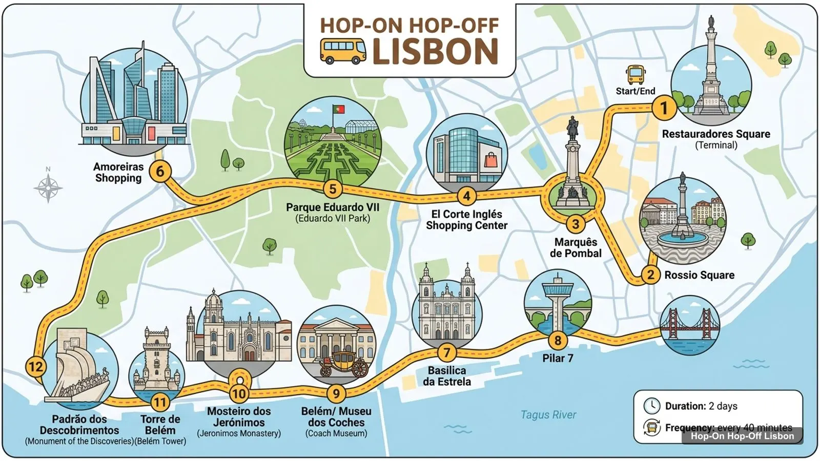
The Lisbon sights map below shows the main Belém line: 12 stops from Restauradores Square out to the Monument to the Discoveries. A bus runs about every 40 minutes on the 1- or 2-day ticket. The line passes Rossio, Marquês de Pombal, Parque Eduardo VII and the Basílica da Estrela before it drops to the river at Belém.
Stops on the route
1Restauradores Square (Terminal)
2Rossio Square
3Marquês de Pombal
4El Corte Inglés Shopping Center
5Parque Eduardo VII ( Eduardo VII Park)
6Amoreiras Shopping
7Basílica da Estrela
8Pilar 7
9Belém/ Museu dos Coches (Coach Museum)
10Mosteiro dos Jerónimos (Jeronimos Monastery)
11Torre de Belém (Belém Tower)
12Padrão dos Descobrimentos (Monument of the Discoveries)
Other tickets have longer lists. The Yellow Bus bus and boat ticket lists 33 entries across two bus lines and the river, adding Alfama, Graça, the National Pantheon, the Tile Museum, Marvila and the Oceanário. City Sightseeing lists 32 stops over three routes (Red, Blue and Green), including the castle. The table above is the shortest line, which is the best one to learn first.
Lisbon Tourist Attractions: Top 20 Sights with Coordinates
This is the Lisbon tourist attractions map in table form, ranked by Google Maps reviews, with exact coordinates. Each link opens the place in Google Maps, where you can save it to a list before you travel. I left out tour operators and ticket offices.
Looking at the coordinates, Lisbon falls into three clusters, and that’s the easiest way to plan a day.
Baixa and Alfama. Praça do Comércio is the anchor. Castelo de São Jorge is 0.8 km from it, Miradouro de Santa Luzia is 0.7 km, and Our Lady of the Mount Viewpoint is 0.6 km from the castle. The Rua Augusta Arch is 0.1 km from the square. This is the cluster you can do on foot, and it’s the one with the hills.
Chiado and Bairro Alto. The Miradouro de São Pedro de Alcântara is 1.1 km from Praça do Comércio and 0.5 km from Praça Luís de Camões. The City Sightseeing listing includes a walking tour that covers the Carmo area and this viewpoint, and its stop list has Bairro Alto.
Belém. Belém Tower, the Monument to the Discoveries and Jerónimos Monastery sit within 1.1 km of each other, and Jerónimos is 0.2 km from the Museu de Marinha. MAAT is 2.0 km east of the tower along Avenida Brasília. This cluster is 6 to 7 km from the Baixa, so it’s the one where a bus earns its price.
Farther out, the Calouste Gulbenkian Museum is 3.7 km from Praça do Comércio, and LX Factory is 3.7 km, with Belém Tower 3.5 km from it. Neither has a bus stop in the lists I checked.
How I’d Read the Map: A Walking Order
I’d use the map in two halves. In the morning, take the bus from Restauradores Square to Belém and walk the cluster: the Monument to the Discoveries first, then Jerónimos Monastery 0.5 km away, then Belém Tower 1.1 km from the monastery. Stay on the river side of Avenida Brasília, because MAAT and the Museum of the Orient are along the same road. In the afternoon, ride back to Praça do Comércio and walk uphill. The square, the arch, the cathedral and the castle line up in a short chain, and the two viewpoints at Santa Luzia and Portas do Sol are within 0.4 km of the castle.
The reason I split it like this is the distance between clusters. Belém is about 7.1 km from the square, so doing both on foot costs you half a day. A bus ticket turns that into a ride with commentary. Once you’re back in the centre, everything is close enough to walk, and the coordinates in the table let you check a distance yourself before you commit.
Hills, Trams and Getting Between Clusters
The one thing the map can’t show is the slope. The Baixa is flat, and Alfama, the castle and Chiado are not. The Yellow Bus 1- or 2-day ticket includes Carris public trams and the Carris Museum for as long as it’s valid, so I’d treat the tram as the way up the hills and the bus as the way along the river. The all-in-one ticket adds the Hills tram tour and the new Royal and Legacy tram. The listing says access to the Santa Justa lift and the funiculars is suspended, so don’t plan around them.
Lisbon Tour Map: Where the Other Tickets Go
The Lisbon tour map isn’t only bus lines. The Lisboat river boat stops at Ribeira das Naus, Estação Sul e Sueste at Terreiro do Paço, and Princesa Pier next to Belém Tower. It sails every hour from 11:00 to 18:00 between March and October, and every two hours from 11:00 to 17:00 from November to February. The vintage tram tour stops at Praça do Comércio, Ajuda and Belém. The tuk tuk tours go where buses can’t: Alfama, Graça, Chiado, Baixa, Bairro Alto, the Pink Street and Mercado da Ribeira.
Lisbon Sightseeing Map: Which Ticket Matches Which Area
If your sightseeing map is mostly Belém and the Baixa, the Yellow Bus 1- or 2-day ticket at $24.77 does the job. If you want the castle, City Sightseeing at $37.16 is the one with the stop. If you want the river as well, the bus and boat ticket is $27.02.
Some of the places people most want to find on a Lisbon tourist map have no bus stop in the lists I checked: Lisbon Cathedral, the Carmo Archaeological Museum, the Calouste Gulbenkian Museum and LX Factory. The Pink Street is rated 3.7 from 11,928 reviews, the lowest on my top 20, so I wouldn’t plan a day around it. For the places without a stop, the tables give coordinates, and you can drop them into a walking route in Google Maps.
Lisbon Sites Map: Use It with Your Phone
Tap any Google Maps link in the tables and save it to a list. In Google Maps you can download the area for offline use, and the links I’ve used include the place ID, so they open the exact place and not a similar name. Distances on this page are straight-line from the coordinates, so allow more for hills and one-way streets.
This page works as one. The route image shows the Belém bus line with numbered stops, and the tables below list 12 bus stops and the top 20 attractions with coordinates. Print the page, or open any Google Maps link and save the place to your phone for offline use before you head out.
Where are most Lisbon attractions on the map?+
They sit in three clusters. The riverside Baixa and Alfama have Praça do Comércio, the castle and the viewpoints, all within about a kilometre. Belém, around 6 to 7 km west, has the tower, the monastery and the Monument to the Discoveries. Chiado and Bairro Alto sit in between, uphill from the square.
How far apart are the main Lisbon sights?+
Praça do Comércio to Castelo de São Jorge is about 0.8 km as the crow flies, and uphill. Belém Tower, the Monument to the Discoveries and Jerónimos are within 0.5 to 1.1 km of each other. Between the square and Belém Tower it's about 7.1 km, which is why I'd take the bus there.
Which hop-on hop-off stops are closest to the top sights?+
Belém Tower, the Monument to the Discoveries, Jerónimos Monastery and MAAT are all stops on the Yellow Bus and City Sightseeing lists. Praça do Comércio is a stop on the all-in-one bus, tram and boat ticket and the vintage tram, and Castelo de São Jorge appears only on City Sightseeing's list.
Tours I compared in Lisbon
My full review of each one, in the order I rank them: