The Las Palmas tourist map you need is really two maps: the bus route along the coast and the attractions people actually visit. Below I list all 10 stops from the City Sightseeing listing, then the top 20 sights by Google Maps reviews with coordinates and map links. For the ticket and how the route works, see my hop-on hop-off Las Palmas guide.
Everything here comes from the bus listing and from Google Maps data I pulled on 7 October 2026. The tables were generated from that data rather than typed by hand. Distances are straight-line figures between the listed coordinates.
Las Palmas Tourist Map: The Bus Route
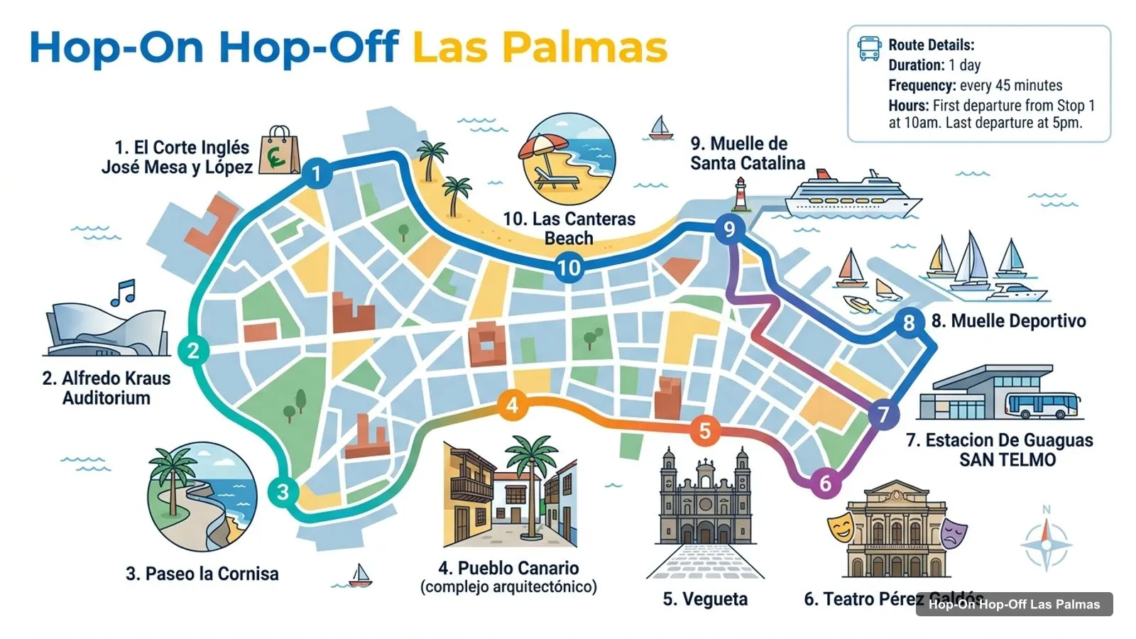
The red route runs from the department store El Corte Inglés through the scenic middle of the city to the old town, then north to the port and Las Canteras beach. The route graphic below shows the stops in order.
The listing’s description numbers 11 stops and starts at Parque de Santa Catalina, with the Poema del Mar Aquarium as stop 10, while the structured list above has 10. I’d treat the two extra names as real stops until the operator says otherwise, and check on the booking page. The loop takes 75 minutes and a bus leaves every 45.
Las Palmas Tourist Attractions: Top 20 by Google Reviews
These are the 20 most-reviewed places in my Las Palmas data, not counting the bus office and a bus stop listing. Six of them are out on the island rather than in the city centre, and the clusters below separate them. Ratings are Google ratings with the number of reviews in brackets.
The top 20 collapse into three clusters, and I’d plan each day around one of them.
Port and Las Canteras (north). The Poema del Mar Aquarium, Parque de Santa Catalina, the Elder Museum, La Luz Castle and La Puntilla all sit within about a kilometre of each other in a straight line, though La Luz Castle needs a walk of about 2 km around the harbour from the aquarium. The aquarium is 540 metres from the park, and La Puntilla is 940 metres from it. This is the cluster where you start the bus.
Vegueta and Triana (south). The Catedral de Santa Ana, the Casa de Colón, the Museo Canario and Plaza de las Ranas are within about 150 metres of each other, which makes Vegueta the easiest place to walk. San Telmo Park is about 920 metres from the cathedral.
The island (outside the city). Palmitos Park, the Roque Nublo, the Mirador Pico Bandama, El Bufadero, the Cueva Pintada Museum and the Artenara cave houses are not on the bus route. From Parque de Santa Catalina they are 38.7, 25.9, 11.7, 16.3, 22.0 and 25.0 km away in a straight line.
One thing to watch when you search Google Maps for the bus stops: a listing called Hop On Hop Off REAL Bus Stop #10 sits near the aquarium, with only 13 reviews and a 2.7 rating, and I can’t tell from the data which operator it belongs to. I wouldn’t rely on it as proof of a stop. Use the stop names from the table above, and ask the driver or the City Sightseeing office if a stop is unclear.
Which Stop for Which Sight on the Las Palmas Tourist Map
If you have a particular sight in mind, this is the stop I’d use. It’s based on the stop names in the listing and the coordinates in my data.
Poema del Mar Aquarium: the harbour stops (Muelle Deportivo and Muelle de Santa Catalina), or the listing description’s stop 10.
Las Canteras beach and La Puntilla: the Las Canteras Beach stop, which is the last on the structured list.
Catedral de Santa Ana, Casa de Colón and Museo Canario: the Vegueta stop, with the walking tour leaving from the Vegueta and Cathedral stop.
Parque Doramas: the Pueblo Canario stop, since the village sits inside the park.
San Telmo Park: the San Telmo bus station stop.
Elder Museum: Parque de Santa Catalina, the description’s stop 1.
Las Palmas Tourist Information and Tourist Guide
For tourist information in Las Palmas, the one office I can confirm in my data is the City Sightseeing office at Calle Luis Morote 6, first floor, office 4. Google Maps lists it as open 9am to 5pm on Monday and gives it 3.4 stars from 252 reviews, so I’d treat it as a place to ask about the bus, not as a general visitor centre.
For a guide, the walking tour of Vegueta is the one that comes with the bus ticket. It runs Monday to Saturday at 11:45 in Spanish and 13:10 in English, lasts 90 minutes and leaves from the Vegueta and Cathedral stop, opposite Teatro Guiniguada. The audio guide on the bus is the other guide you get. The listing says 15 languages, while the operator’s page says 8, so check your language before you book.
Las Palmas Tourist Map PDF and Printing
I don’t host a PDF of the Las Palmas tourist map, and I’d rather not link a file I haven’t checked. The Google Maps links in the tables above do the same job: open one, save it to a list on your phone and you have an offline pin for each stop. For a paper map, ask at the City Sightseeing office listed above, or at your hotel.
Las Palmas Tourist Map Walking Tips
Walk Vegueta, ride between areas. The old town sights are inside 150 metres of the cathedral, but the full 4.7 km from the park to Vegueta is the stretch the bus saves you. In Vegueta, the museums keep different hours: the Museo Canario is open 10am to 8pm on weekdays and 10am to 2pm on weekends, and the Casa de Colón opens 10am to 6pm Monday to Saturday and until 3pm on Sunday.
On the north side, the Elder Museum and La Luz Castle are both closed on Mondays. If you are in town on a Monday, the aquarium (9:30am to 5:30pm daily), the parks and the beach are your safe choices.
Which Bus Ticket Covers the Most of This Map?
There is only one bus, so the question is which ticket level. The base 24-hour ticket gets you the ride and the Vegueta walking tour. The 24-hour Experience ticket adds the Museo Elder and a boat tour. The 48-hour Premium Experience ticket lists the cathedral and tower, the Museo Canario, the Museum of Sacred Art and the Castillo de la Luz, so it covers the most of the map for people who want to go inside.
The simplest free option is the Google Maps links on this page, one for every bus stop and one for each of the top 20 attractions. The City Sightseeing bus also has an office at Calle Luis Morote 6, about 140 metres from Parque de Santa Catalina, which is the most practical place to ask for a printed route map.
How far apart are the main areas of Las Palmas?+
Parque de Santa Catalina and the Catedral de Santa Ana are about 4.7 km apart in a straight line, and Parque Doramas sits between them, about 2.2 km from the park and 2.7 km from the cathedral. The red bus links all three, so you don't need to walk the whole stretch.
Which Las Palmas sights are on the bus route?+
The listing's stop list includes the Alfredo Kraus Auditorium, Paseo la Cornisa, Pueblo Canario, Vegueta, the Teatro Pérez Galdós, the San Telmo bus station, the harbour piers and Las Canteras beach. The listing's description also names Parque de Santa Catalina and the Poema del Mar Aquarium, which the stop list leaves out.
Tours I compared in Las Palmas
My full review of each one, in the order I rank them: