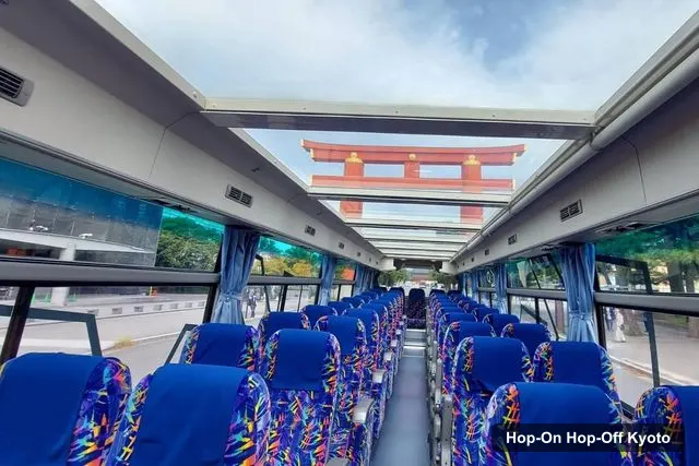
Myojo bus Co.
Kyoto: Hop-on Hop-off Sightseeing Bus Ticket
- 3.9 (2,414 reviews)
- 2-day ticket
My pick: Covers the most of this map: twelve named stops on two lines, with an audio guide, from $27.19.
By Jake Dawson · Updated · Affiliate links, explained in my disclosure
Myojo bus Co.
Kyoto: Hop-on Hop-off Sightseeing Bus Ticket
3.9 (2,414) · from $27.19
A Kyoto tourist map makes more sense once you see the city as five groups of sights, and this Kyoto tourist map shows both the bus stops and the attractions. I’ve put the sightseeing bus stops and the top 20 attractions (ranked by Google Maps reviews) on one page, with coordinates and a Google Maps link for each. If you want to ride between them, my guide to hop-on hop-off in Kyoto explains the ticket.
The route data comes from the operator’s GetYourGuide listing, which names twelve stops but gives no numbered stop list or timetable. The coordinates and ratings come from Google Maps data, checked October 2026. I’ve kept the two sources apart on purpose, so you can see which sights the bus names and which it doesn’t.
The Kyoto tour map is a figure of eight. The Red Line is the West Line, the Blue Line is the East Line, both begin and end at Kyoto Station, and they connect at Shijo Karasuma next to Nishiki Market. The image below is my sights map: it numbers ten of the most-reviewed museums and sights, and isn’t the operator’s route diagram.
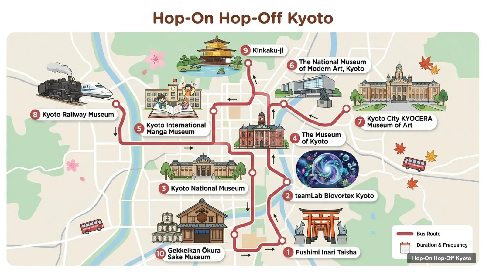
Stops on the route
| # | Sight | Map |
|---|---|---|
| 1 | Fushimi Inari Taisha | Open in Google Maps |
| 2 | teamLab Biovortex Kyoto | Open in Google Maps |
| 3 | Kyoto National Museum | Open in Google Maps |
| 4 | The Museum of Kyoto | Open in Google Maps |
| 5 | Kyoto International Manga Museum | Open in Google Maps |
| 6 | The National Museum of Modern Art, Kyoto | Open in Google Maps |
| 7 | Kyoto City KYOCERA Museum of Art | Open in Google Maps |
| 8 | Kyoto Railway Museum | Open in Google Maps |
| 9 | Kinkaku-ji | Open in Google Maps |
| 10 | Gekkeikan Ōkura Sake Museum | Open in Google Maps |
The Kyoto sightseeing map is easiest to read as two lists of six. These are the sights the listing says the buses serve, in the order it gives them, with a Google Maps search link for each. I haven’t invented stop numbers or times.
| Line | Stop | Map |
|---|---|---|
| Red (West) | Nijo Castle | Search on Google Maps |
| Red (West) | Kitano Tenmangu Shrine | Search on Google Maps |
| Red (West) | Kinkaku-ji (Golden Pavilion) | Search on Google Maps |
| Red (West) | Daitoku-ji Temple | Search on Google Maps |
| Red (West) | Kyoto Imperial Palace | Search on Google Maps |
| Red (West) | Nishiki Market | Search on Google Maps |
| Blue (East) | Kyoto City Hall | Search on Google Maps |
| Blue (East) | Ginkaku-ji (Silver Pavilion) | Search on Google Maps |
| Blue (East) | Heian-jingu Shrine | Search on Google Maps |
| Blue (East) | Gion | Search on Google Maps |
| Blue (East) | Kiyomizu-dera Temple | Search on Google Maps |
| Blue (East) | Sanjusangendo / Kyoto National Museum | Search on Google Maps |
| Both | Kyoto Station, JR1 bus stop (start and end) | Search on Google Maps |
| Both | Shijo Karasuma / Nishiki Market (connection) | Search on Google Maps |
The meeting point is the JR1 bus stop at Kyoto Station, in the Higashishiokoji area of Shimogyo Ward. Buses stop for severe weather, so check on the day.
This Kyoto sights map lists the 20 most-reviewed places in my data, with the straight-line distance from the Kyoto Station bus stop. Coordinates are in decimal degrees, and the link opens the place in Google Maps. I built the table from the data file with a script, not by hand.
| # | Attraction | Rating (reviews) | Lat, Lng | km from station | Map |
|---|---|---|---|---|---|
| 1 | Fushimi Inari Taisha | 4.6 (92,147) | 34.9677, 135.7792 | 2.9 | Map |
| 2 | Kinkaku-ji | 4.6 (70,832) | 35.0394, 135.7292 | 6.4 | Map |
| 3 | Kyoto Railway Museum | 4.6 (20,043) | 34.9871, 135.7423 | 1.4 | Map |
| 4 | Kyoto National Museum | 4.3 (8,319) | 34.9900, 135.7731 | 1.4 | Map |
| 5 | Kyoto City KYOCERA Museum of Art | 4.4 (7,363) | 35.0129, 135.7836 | 3.7 | Map |
| 6 | Kyoto International Manga Museum | 4.2 (6,663) | 35.0119, 135.7594 | 2.8 | Map |
| 7 | teamLab Biovortex Kyoto | 4.6 (5,542) | 34.9837, 135.7649 | 0.7 | Map |
| 8 | The Museum of Kyoto | 4.1 (5,534) | 35.0092, 135.7624 | 2.5 | Map |
| 9 | Gekkeikan Ōkura Sake Museum | 4.2 (4,796) | 34.9291, 135.7616 | 6.4 | Map |
| 10 | The National Museum of Modern Art, Kyoto | 4.1 (3,835) | 35.0124, 135.7822 | 3.6 | Map |
| 11 | Japan Kanji Museum & Library | 4.1 (1,747) | 35.0035, 135.7766 | 2.5 | Map |
| 12 | Fukuda Art Museum | 4.3 (1,301) | 35.0138, 135.6764 | 8.0 | Map |
| 13 | Hosomi Museum | 4 (1,037) | 35.0138, 135.7796 | 3.6 | Map |
| 14 | Garden of Fine Arts Kyoto | 4.3 (963) | 35.0507, 135.7654 | 7.1 | Map |
| 15 | Kyoto Museum of Crafts and Design | 4.3 (805) | 35.0132, 135.7812 | 3.6 | Map |
| 16 | Shokoku-ji Jotenkaku Museum | 4.3 (670) | 35.0336, 135.7627 | 5.2 | Map |
| 17 | Kaleidoscope Museum of Kyoto | 4.2 (534) | 35.0097, 135.7616 | 2.6 | Map |
| 18 | Raku Museum | 4.3 (512) | 35.0255, 135.7535 | 4.3 | Map |
| 19 | Kyoto Shibori Museum | 4.8 (328) | 35.0101, 135.7537 | 2.6 | Map |
| 20 | Sumiya Cultural Art Museum | 4.4 (242) | 34.9923, 135.7432 | 1.5 | Map |
The Kyoto sites map breaks into five clusters, and I’d plan one half day for each.
The Kyoto tourist map looks compact on a screen, but the straight-line distances in the table understate the real walking. Kinkaku-ji is about 6.4 km from the station by crow-flight distance, and the Fushimi pair is further apart than it looks. For every sight more than about 1.5 km from a bus stop, I’d plan a bus, a train or a taxi, and keep walking for the clusters.
Two clusters reward walking. In Okazaki, the KYOCERA Museum of Art and the National Museum of Modern Art are about 140 m apart. Around Kyoto Station, teamLab Biovortex Kyoto is the nearest sight at about 0.7 km. Wherever you walk, open the Google Maps link first, because it routes along the streets, which a straight line can’t.
The distance column in the top 20 table is measured from the Kyoto Station bus stop, using the coordinates of the Sky Hop Bus Kyoto station place in my data. Treat it as a ranking, not a journey time. A sight at 2.5 km can take longer than one at 3.7 km if the route needs a transfer.
The ratings come from Google Maps. A high rating with few reviews, such as the Kyoto Shibori Museum at 4.8 from 328 reviews, tells you less than a 4.6 from 92,147 reviews at Fushimi Inari Taisha. I rank by review count for that reason, and I’d use the rating only to separate sights with similar counts.
If Kinkaku-ji is your reason for visiting, the Red Line is the one to ride. If Kiyomizu-dera, Gion or Ginkaku-ji are, take the Blue Line. For anything in the Fushimi cluster, take a train. Rather than learn every stop, pick the cluster you want and ride only the line that serves it.
Each half-day is easiest on the Kyoto National Museum days when it’s open: closed Mondays, open until 8 PM on Fridays. For a plan that strings the clusters together, see my Kyoto itinerary.
There is no single official PDF I can point to from my data. The operator’s site, skyhopbus.com/kyoto, is the place to look for its current route map, and the official Kyoto travel guide has city maps and event information. For a printable version of my own, print this page, or save the Google Maps links in a list on your phone.
For a Kyoto sightseeing map PDF, I’d skip the paper and download an offline area in a map app, then star the places from the tables above. That way you can see the distance to the nearest stop even without data. The tables use the same names as Google Maps, so a search will find them.
If you’d rather ride than navigate, the bus ticket starts at $27.19 for 1 or 2 days, with an audio guide in 7 languages and Wi-Fi on board.
Only one product in my data covers more than a single sight: the sightseeing bus, with twelve named stops across two lines. The Naoshima day trip leaves Kyoto altogether, so it doesn’t appear on this map. For more on the sights themselves, see the best things to do in Kyoto, and for my other city maps head to the homepage.
Myojo bus Co.
My pick: Covers the most of this map: twelve named stops on two lines, with an audio guide, from $27.19.
This page works as one. The map image numbers ten major sights, and the tables below list the twelve named sightseeing bus stops and the top 20 attractions with coordinates. Print the page, or open any Google Maps link and save the places to your phone for offline use.
In five rough groups. Around Kyoto Station you have teamLab, the Railway Museum and the Kyoto National Museum. South-east is Fushimi Inari. The east has the Okazaki museums and Gion, the centre has the smaller museums, and the north-west has Kinkaku-ji. Each group is a good unit for one half day.
From the bus stop at Kyoto Station, straight-line distances are about 0.7 km to teamLab Biovortex, 1.4 km to the Railway Museum, 2.9 km to Fushimi Inari Taisha, 3.7 km to the KYOCERA Museum of Art and 6.4 km to Kinkaku-ji. Real routes are longer, so use a map app.
Yes, the operator publishes one for the Red Line and Blue Line, but I couldn't copy a stop-by-stop diagram from the listing. I give the twelve stop names it lists and the connection point at Shijo Karasuma. Check the Sky Hop Bus Kyoto page for the current map before you ride.
My full review of each one, in the order I rank them: