Globaltix Sdn Bhd
Kuala Lumpur: Hop-On Hop-Off Sightseeing Bus Pass
- 3.8 (1,189 reviews)
- 2-day ticket
My pick: Covers both routes on this map, from $9.67, with 24h and 48h options.
By Jake Dawson · Updated · Affiliate links, explained in my disclosure
Globaltix Sdn Bhd
Kuala Lumpur: Hop-On Hop-Off Sightseeing Bus Pass
3.8 (1,189) · from $9.67
A Kuala Lumpur tourist map makes more sense once you see the city as three clusters joined by two bus loops. I’ve put the top 20 attractions (ranked by Google Maps reviews) and every stop on the city’s sightseeing bus routes on one page, with coordinates and a Google Maps link for each. To pick the ticket that rides these routes, see my comparison of hop-on hop-off in Kuala Lumpur.
All distances on this page are straight-line, measured between the Google Maps coordinates of each place, so expect a little more on foot.
The Kuala Lumpur sightseeing map below shows the first 12 stops of the City Route, from SG Wang in Bukit Bintang through Kampung Baru, KLCC and the KL Tower to TRX. Buses run daily from 9am to 6pm, every 20 to 40 minutes depending on the listing, and the last pick-up at any stop is 4pm.
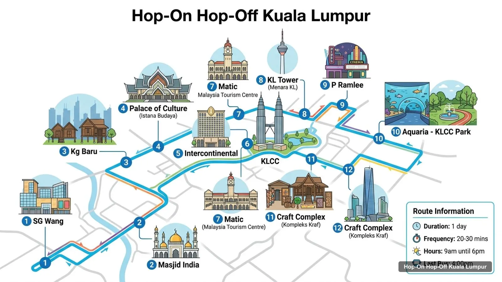
Stops on the route
| # | Stop | Map |
|---|---|---|
| 1 | SG Wang | Find on Google Maps |
| 2 | Masjid India | Find on Google Maps |
| 3 | Kg Baru | Find on Google Maps |
| 4 | Palace of Culture | Find on Google Maps |
| 5 | Intercontinental | Find on Google Maps |
| 6 | KLCC | Find on Google Maps |
| 7 | Matic | Find on Google Maps |
| 8 | KL Tower | Find on Google Maps |
| 9 | P Ramlee | Find on Google Maps |
| 10 | Aquaria - KLCC Park | Find on Google Maps |
| 11 | Craft Complex | Find on Google Maps |
| 12 | TRX | Find on Google Maps |
| 13 | Bukit Bintang | Find on Google Maps |
| 14 | Tengkat Tong Shin | Find on Google Maps |
| # | Stop | Map |
|---|---|---|
| 1 | SG Wang | Find on Google Maps |
| 2 | Swiss Garden | Find on Google Maps |
| 3 | Chinatown | Find on Google Maps |
| 4 | Central Market | Find on Google Maps |
| 5 | Little India | Find on Google Maps |
| 6 | KL Sentral | Find on Google Maps |
| 7 | National Museum | Find on Google Maps |
| 8 | National Palace | Find on Google Maps |
| 9 | Bird Park | Find on Google Maps |
| 10 | National Mosque | Find on Google Maps |
| 11 | Merdeka Square | Find on Google Maps |
| 12 | Chow Kit | Find on Google Maps |
| 13 | Sunway Putra | Find on Google Maps |
Both routes start at SG Wang, the Sungei Wang stop on Jalan Sultan Ismail, so that’s where you switch from one loop to the other. The stop names come from the operator’s list on GetYourGuide. The Google Maps links search for each stop name, so check the pin against the bus stop sign when you get there.
These are the top Kuala Lumpur tourist attractions in table form, ranked by Google Maps reviews, with exact coordinates. I’ve left out Batu Caves, which is about 9.5 km north of the Petronas Towers and off every bus route, and the bus stops themselves. Each link opens the place in Google Maps, where you can save it to a list before you travel.
| # | Attraction | Coordinates | Google rating | Map |
|---|---|---|---|---|
| 1 | Petronas Twin Towers | 3.15747, 101.71156 | 4.7 (105,492) | Open in Google Maps |
| 2 | KLCC Park | 3.15559, 101.71479 | 4.7 (64,275) | Open in Google Maps |
| 3 | Merdeka Square | 3.14906, 101.69366 | 4.5 (52,520) | Open in Google Maps |
| 4 | Menara Kuala Lumpur | 3.15288, 101.70385 | 4.5 (42,650) | Open in Google Maps |
| 5 | Aquaria KLCC | 3.15355, 101.71318 | 4.3 (41,368) | Open in Google Maps |
| 6 | Perdana Botanical Gardens | 3.14236, 101.68424 | 4.5 (28,137) | Open in Google Maps |
| 7 | Thean Hou Temple | 3.12195, 101.68767 | 4.6 (16,977) | Open in Google Maps |
| 8 | KL Bird Park | 3.14316, 101.68848 | 4.4 (16,724) | Open in Google Maps |
| 9 | The National Museum of Malaysia | 3.13771, 101.68742 | 4.3 (14,714) | Open in Google Maps |
| 10 | Berjaya Times Square Theme Park | 3.14220, 101.71055 | 4.4 (14,511) | Open in Google Maps |
| 11 | Istana Negara | 3.16148, 101.66344 | 4.3 (7,705) | Open in Google Maps |
| 12 | Kuala Lumpur Butterfly Park | 3.14578, 101.68891 | 4.2 (6,153) | Open in Google Maps |
| 13 | Islamic Arts Museum Malaysia | 3.14185, 101.69000 | 4.7 (6,002) | Open in Google Maps |
| 14 | Bank Negara Malaysia Museum and Art Gallery | 3.15716, 101.69048 | 4.6 (5,707) | Open in Google Maps |
| 15 | National Art Gallery | 3.17366, 101.70523 | 4.5 (4,997) | Open in Google Maps |
| 16 | National Monument | 3.14885, 101.68383 | 4.5 (4,353) | Open in Google Maps |
| 17 | Kwai Chai Hong | 3.14147, 101.69761 | 4.3 (4,306) | Open in Google Maps |
| 18 | Asy-Syakirin Masjid | 3.15723, 101.71628 | 4.8 (4,206) | Open in Google Maps |
| 19 | Bangunan Sultan Abdul Samad | 3.14872, 101.69446 | 4.7 (3,304) | Open in Google Maps |
| 20 | Sin Sze Si Ya Temple | 3.14555, 101.69645 | 4.4 (2,459) | Open in Google Maps |
Read the coordinates above and you’ll see three tight groups on the Kuala Lumpur city tourist map:
KLCC to Merdeka Square is about 2.2 km, and Merdeka Square to the Bird Park about 870 metres. Bukit Bintang, with Berjaya Times Square, sits between KLCC and the old centre, about 330 metres from SG Wang. Two places sit outside all three clusters: Thean Hou Temple, about 1.5 km from the KL Sentral stop, and Istana Negara, about 580 metres from the National Palace stop. My best things to do in Kuala Lumpur guide covers what to see at each place.
If you only have time for one loop, this is how the Kuala Lumpur tourist map splits between the two routes. The City Route covers 7 of my top 20: the Petronas Twin Towers, KLCC Park, Menara Kuala Lumpur, Aquaria KLCC, the National Art Gallery near the Palace of Culture stop, the Asy-Syakirin mosque by KLCC, and Berjaya Times Square near SG Wang and Bukit Bintang. The Garden Route covers more of the list: Merdeka Square, the Perdana Botanical Gardens, the KL Bird Park, the National Museum, Istana Negara, the Butterfly Park, the Islamic Arts Museum, the National Monument, Kwai Chai Hong, the Sultan Abdul Samad Building and Sin Sze Si Ya Temple. So the Garden Route is the one for history and gardens, while the City Route is the one for the skyline. Thean Hou Temple and the Bank Negara museum are the two top-20 places neither route serves well.
Opening hours matter as much as distances when you plan a route on the Kuala Lumpur tourist map. The Petronas Twin Towers open 9am to 9pm but close on Mondays, and so does the Bank Negara museum. Menara Kuala Lumpur is open 9am to 10pm every day, and Aquaria KLCC 10am to 8pm on weekdays, 9am to 9pm at weekends. In the Perdana gardens, the Bird Park opens 9am to 5:30pm and the Butterfly Park closes earlier, at 4:30pm, while the National Museum is open 9am to 5pm. Merdeka Square is open 24 hours and Kwai Chai Hong until midnight, which makes the old centre the best cluster for the evening, after the buses stop.
The Kuala Lumpur tourist map gets easier once you know which stop serves which sight:
On a Kuala Lumpur travel map, the bus is the simplest link between the clusters, but it’s not the only one. KL Sentral, a Garden Route stop, is the city’s main rail hub, and several stop names, such as KLCC, Bukit Bintang and TRX, match train stations too. That helps when the bus has stopped for the day at 4pm. For Batu Caves and Thean Hou Temple, I’d use a train or a taxi. If you want those days laid out hour by hour, see my Kuala Lumpur itinerary for 1, 2 and 3 days.
If you want a Kuala Lumpur tourist map as a PDF, print this page with your browser’s “Print to PDF” option. The route image and the three tables fit on a few sheets, and the Google Maps links stay clickable on a phone or tablet. For a download that works offline, I’d save the 20 attractions to a starred list in Google Maps and download the city area for offline use. The operator also sends a route map with your e-tickets on one of the two GetYourGuide listings.
KL’s clusters are walkable inside, but the gaps between them are long in tropical heat. Walk within KLCC and within the old centre, and ride between them. Start the Perdana gardens early, because they open at 5:30am and the shade helps. Keep an umbrella for afternoon storms, which can delay or suspend the open-top buses.
Both GetYourGuide tickets ride the same City and Garden routes, so either covers every stop on this Kuala Lumpur tourist map. If you want the bus tour I’d book in Kuala Lumpur for this route, it’s on my Kuala Lumpur sightseeing bus comparison, and the rest of my city maps start from the homepage.
Globaltix Sdn Bhd
My pick: Covers both routes on this map, from $9.67, with 24h and 48h options.
This page works as one: the route map image shows the City Route with numbered stops, and the tables below list every stop on both bus routes and the top 20 attractions with coordinates. Print the page, or save the Google Maps links to a list on your phone so they work offline.
In three clusters. KLCC has the Petronas Twin Towers, KLCC Park and Aquaria KLCC, with the KL Tower about 1 km west. The old centre has Merdeka Square, the Sultan Abdul Samad Building and Chinatown. The Perdana gardens hold the Bird Park, the Butterfly Park, the Islamic Arts Museum and the National Museum.
The Petronas Twin Towers and Merdeka Square are about 2.2 km apart in a straight line. Merdeka Square to the KL Bird Park is about 870 metres, and the Petronas Towers to the KL Tower about 1 km. Batu Caves is the outlier, about 9.5 km north of the towers.
My full review of each one, in the order I rank them: