Halifax Tourist Map: Top Attractions & Bus Stops
By Jake Dawson · Updated · Affiliate links, explained in my disclosure

Ambassatours Gray Line
Halifax: Hop-on Hop-Off Double-Decker Bus City Tour
4.2 (156) · from $71.36

A Halifax tourist map is more useful when it shows two things at once: where the sights cluster and where the bus stops. This page does both. The seven bus stops come from the GetYourGuide listing for the Ambassatours Gray Line hop-on hop-off bus, and the sights come from Google Maps. For prices and the timetable, see my hop-on hop-off Halifax guide.
I generated the tables below from the place data rather than typing numbers by hand. Coordinates are Google Maps latitude and longitude, and distances are straight-line figures to the nearest numbered stop I can place on the map. Streets and hills add to them.
Halifax Sightseeing Map: The Hop-On Hop-Off Route
The Halifax sightseeing map is a short loop of seven stops, 60 minutes end to end, with a live guide on board. The route starts at the cruise terminal and the Canadian Museum of Immigration at Pier 21, runs north to the Maritime Museum, climbs to St. Mary’s Basilica and the Public Gardens, reaches the Citadel, detours to Fairview Lawn Cemetery and returns to the Art Gallery of Nova Scotia and Province House.
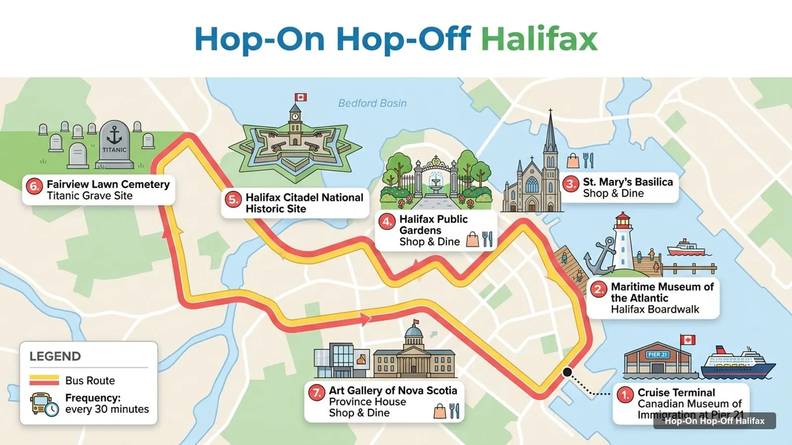
Stops on the route
- 1Cruise Terminal / Canadian Museum of Immigration at Pier 21
- 2Maritime Museum of the Atlantic / Halifax Boardwalk
- 3St. Mary’s Basilica / Shop & Dine
- 4Halifax Public Gardens / Shop & Dine
- 5Halifax Citadel National Historic Site
- 6Fairview Lawn Cemetery / Titanic Grave Site
- 7Art Gallery of Nova Scotia / Province House / Shop & Dine
The ticket kiosk is at stop 2, the Maritime Museum, and the operator says you cannot board at stop 1. The listing’s “know before you go” note calls the kiosk stop 3, which contradicts the numbered list, so I follow the numbered list. The bus departs about every 30 minutes depending on the season and traffic, and the tourism listing gives the season as June 14 to October 29.
Hop On Hop Off Halifax Bus Stops
Here are the seven stops, each with a Google Maps search link. I have not got street addresses for the stops themselves, because the listing gives names rather than coordinates, so the links search for the named place.
| # | Stop | Map |
|---|---|---|
| 1 | Cruise Terminal / Canadian Museum of Immigration at Pier 21 | Find on Google Maps |
| 2 | Maritime Museum of the Atlantic / Halifax Boardwalk | Find on Google Maps |
| 3 | St. Mary’s Basilica / Shop & Dine | Find on Google Maps |
| 4 | Halifax Public Gardens / Shop & Dine | Find on Google Maps |
| 5 | Halifax Citadel National Historic Site | Find on Google Maps |
| 6 | Fairview Lawn Cemetery / Titanic Grave Site | Find on Google Maps |
| 7 | Art Gallery of Nova Scotia / Province House / Shop & Dine | Find on Google Maps |
Stops 3 and 6 are not in my place data, so I cannot give coordinates for them. Stop 6, Fairview Lawn Cemetery, is a detour from the downtown core, and a reviewer notes that the guide got off the bus there to point out the path to the Titanic section. Stop 7 is the end of the loop and the best place to get off for the Art Gallery of Nova Scotia and Historic Properties.
Halifax Nova Scotia Attractions: The Top 20
The top 20 Halifax Nova Scotia attractions below are ranked by Google Maps review count, checked October 2026. I excluded tour operators, bus-company listings and places far outside the city. The last column is the straight-line distance from the attraction to the nearest numbered bus stop that I can place on the map: stops 1, 2, 4, 5 and 7.
| # | Attraction | Rating | Reviews | Latitude, longitude | Nearest stop (km) | Map |
|---|---|---|---|---|---|---|
| 1 | Halifax Waterfront | 4.8 | 10,139 | 44.6457, -63.5693 | 0.2 (stop 2) | Open in Google Maps |
| 2 | Halifax Citadel National Historic Site | 4.7 | 8,863 | 44.6475, -63.5796 | Stop 5 | Open in Google Maps |
| 3 | Halifax Public Gardens | 4.8 | 8,253 | 44.6428, -63.5821 | Stop 4 | Open in Google Maps |
| 4 | Maritime Museum of the Atlantic | 4.6 | 6,117 | 44.6475, -63.5706 | Stop 2 | Open in Google Maps |
| 5 | Point Pleasant Park | 4.7 | 4,458 | 44.6277, -63.5668 | 1.2 (stop 1) | Open in Google Maps |
| 6 | Canadian Museum of Immigration at Pier 21 | 4.7 | 3,943 | 44.6384, -63.5652 | Stop 1 | Open in Google Maps |
| 7 | Museum of Natural History | 4.5 | 2,773 | 44.6455, -63.5851 | 0.4 (stop 4) | Open in Google Maps |
| 8 | Sir Sandford Fleming Park | 4.7 | 1,460 | 44.6300, -63.6019 | 2.1 (stop 4) | Open in Google Maps |
| 9 | Art Gallery of Nova Scotia | 4.5 | 1,375 | 44.6482, -63.5728 | Stop 7 | Open in Google Maps |
| 10 | York Redoubt National Historic Site | 4.6 | 837 | 44.5968, -63.5532 | 4.7 (stop 1) | Open in Google Maps |
| 11 | Historic Properties | 4.4 | 725 | 44.6501, -63.5732 | 0.2 (stop 7) | Open in Google Maps |
| 12 | Discovery Centre | 4.2 | 633 | 44.6418, -63.5676 | 0.4 (stop 1) | Open in Google Maps |
| 13 | Grand Parade | 4.6 | 614 | 44.6480, -63.5748 | 0.2 (stop 7) | Open in Google Maps |
| 14 | Fort Needham Memorial Park | 4.7 | 555 | 44.6646, -63.6000 | 2.5 (stop 5) | Open in Google Maps |
| 15 | Horseshoe Island Park | 4.7 | 500 | 44.6403, -63.6136 | 2.5 (stop 4) | Open in Google Maps |
| 16 | Steele Wheels Motor Museum | 4.8 | 453 | 44.6482, -63.6693 | 6.9 (stop 4) | Open in Google Maps |
| 17 | Africville Museum | 4.8 | 422 | 44.6739, -63.6195 | 4.3 (stop 5) | Open in Google Maps |
| 18 | Victoria Park | 4.3 | 398 | 44.6408, -63.5796 | 0.3 (stop 4) | Open in Google Maps |
| 19 | Africville Park | 4.5 | 376 | 44.6754, -63.6164 | 4.3 (stop 5) | Open in Google Maps |
| 20 | Halifax Explosion Memorial Bell Tower | 4.7 | 321 | 44.6658, -63.6011 | 2.7 (stop 5) | Open in Google Maps |
Halifax Things to See and Do: Clusters
The Halifax things to see and do group into four clusters. If you plan by cluster, you avoid backtracking.
Waterfront cluster. Pier 21, the Discovery Centre, the Maritime Museum, HMCS Sackville, Historic Properties and Queen’s Marque are all within about 1.1 km of each other along Lower Water Street. Bus stops 1 and 2 serve this cluster, and the kiosk is here. This is the best place to start and finish, and the Waterfront boardwalk ties it together.
Citadel and Gardens cluster. The Citadel, the Public Gardens, the Museum of Natural History, Victoria Park and the Old Town Clock sit on and around the hill, and each is within 0.6 km or so of stop 4 or 5. Stops 4 and 5 serve this cluster, and it is where the bus saves the most effort. Parks Canada lists the Citadel’s indoor exhibits as open daily from 9 am to 5 pm from May 7 to November 5, 2026.
Southern parks. Point Pleasant Park and the Prince of Wales Tower National Historic Site lie to the south, and Sir Sandford Fleming Park and Horseshoe Island Park are on the North West Arm to the west. These are 1.2 to 2.5 km from the nearest stop. You need to walk, take a taxi or use local transit.
North End. Fort Needham Memorial Park, the Halifax Explosion Memorial Bell Tower and the Africville sites are in the north of the peninsula, about 2.5 km or more from the Citadel stop. The Africville Museum is rated 4.8 from 422 reviews. The bus does not go there.
Halifax Tourist Attractions Beyond the Bus
Several Halifax tourist attractions are outside the loop, and I would not try to reach them on a one-day ticket. York Redoubt is 4.7 km from the nearest stop, and Peggy’s Cove is about 32 km from the Maritime Museum in a straight line. The Peggy’s Cove coach is a separate 4-hour ticket at $77.06, with 70 minutes of driving each way and 100 minutes at the village.
If your port call is short, stick to the waterfront cluster. If you have a full day, ride the loop and add the Citadel cluster. If you have a second day, take the coast. My Halifax itinerary turns these clusters into one, two and three-day plans, and my best things to do in Halifax ranks the sights in more detail.
How to Read the Halifax Tourist Map by Distance
The simplest way to use a Halifax tourist map is to think in kilometres, not stop numbers. From the coordinates in my place data, the Maritime Museum is 1.1 km from Pier 21, the Citadel is 0.7 km from the Maritime Museum, and the Public Gardens are 0.6 km from the Citadel and 1.1 km from the Maritime Museum. The Art Gallery of Nova Scotia is only 0.2 km from the museum kiosk. That means the first and last stops are close on foot, and the long part of the loop is the climb to the Citadel and the detour to the cemetery.
Anything under 0.5 km I would walk. Between 0.5 and 1.5 km, it depends on weather and hills, and the bus is a fair choice if you already hold a pass. Over 2 km, as for Fort Needham, Horseshoe Island Park or Sir Sandford Fleming Park, you will want a taxi or local transit. I have not got local transit routes or fares, since the city’s fares page would not load, so check them locally before you rely on them.
Using the Halifax Tourist Map in Different Seasons
The map is the same all year, but the bus is not. The tourism listing gives the hop-on hop-off season as June 14 to October 29, and the operator’s own pages show other dates, so confirm before you plan. Outside the season, the waterfront and Citadel clusters are still walkable, and Parks Canada lists the grounds of the Citadel as accessible all year, with indoor exhibits open until November 5, 2026. The Peggy’s Cove coach is listed May 3 to October 31, 2026 on the operator’s site.
Halifax Tourist Guide: How I’d Use This Map
My short guide to using the map is this. Save the Google Maps links for the stops you care about, since the bus map shows names and not street positions. Start at the kiosk at 1675 Lower Water Street, ride one loop, and decide on your hop-offs from the commentary. Walk between the clusters only when the gap is under a kilometre.
For the ticket itself, the full comparison is on the Halifax hop-on hop-off page, and the home page lists the other cities.
Frequently asked questions
Is there a hop-on hop-off bus map for Halifax?
Yes. The Ambassatours Gray Line loop has 7 numbered stops, and the map on this page numbers them in the order the GetYourGuide listing gives. The loop takes 60 minutes. The listing order is not a driving order for stops 6 and 7, so use the Google Maps links in the stop table and ask the driver.
What are the top attractions in Halifax, Nova Scotia?
By Google Maps reviews, the top five are the Halifax Waterfront (10,139 reviews), the Citadel (8,863), the Public Gardens (8,253), the Maritime Museum of the Atlantic (6,117) and Point Pleasant Park (4,458). The top-20 table on this page gives coordinates and a Google Maps link for each.
Where does the Halifax hop-on hop-off bus start?
You can board at any stop, but you must first swap your voucher at the kiosk at 1675 Lower Water Street, outside the Maritime Museum of the Atlantic. The operator says check-in is at Stop 2 and you cannot board at Stop 1. The cruise terminal at Pier 21 is Stop 1.
How far apart are the main sights in Halifax?
Close. From Google coordinates, Pier 21 to the Maritime Museum is 1.1 km, the Maritime Museum to the Citadel is 0.7 km, and the Citadel to the Public Gardens is 0.6 km in a straight line. Hills and streets add to those figures, but the core is walkable.
Where is the Halifax tourist information office?
I do not have a verified address for it in my data, so I will not state one. The Nova Scotia tourism listing for the bus gives the operator's phone number, 902-420-1015, and the ticket centre at 1675 Lower Water Street is the starting point I would use on the map.
Tours I compared in Halifax
My full review of each one, in the order I rank them:
- Halifax: Hop-on Hop-Off Double-Decker Bus City Tour★ 4.2 · from $71.36
- From Halifax: Peggy's Cove Bus Tour★ 4.7 · from $77.06