This Funchal tourist map is a set of tables rather than a picture, so you can copy the links into your own Google Maps list. It has the sightseeing bus stops, the top 20 attractions by Google reviews with coordinates, and my notes on which sights sit together. If you need to choose a ticket first, start with hop-on hop-off Funchal.
Coordinates and ratings come from Google Maps, checked October 2026. Stop names come from the operators’ GetYourGuide listings. Distances are straight-line figures that I calculated from the coordinates, so walking distances will be longer on Funchal’s hills.
Funchal Sightseeing Map: The Bus Route
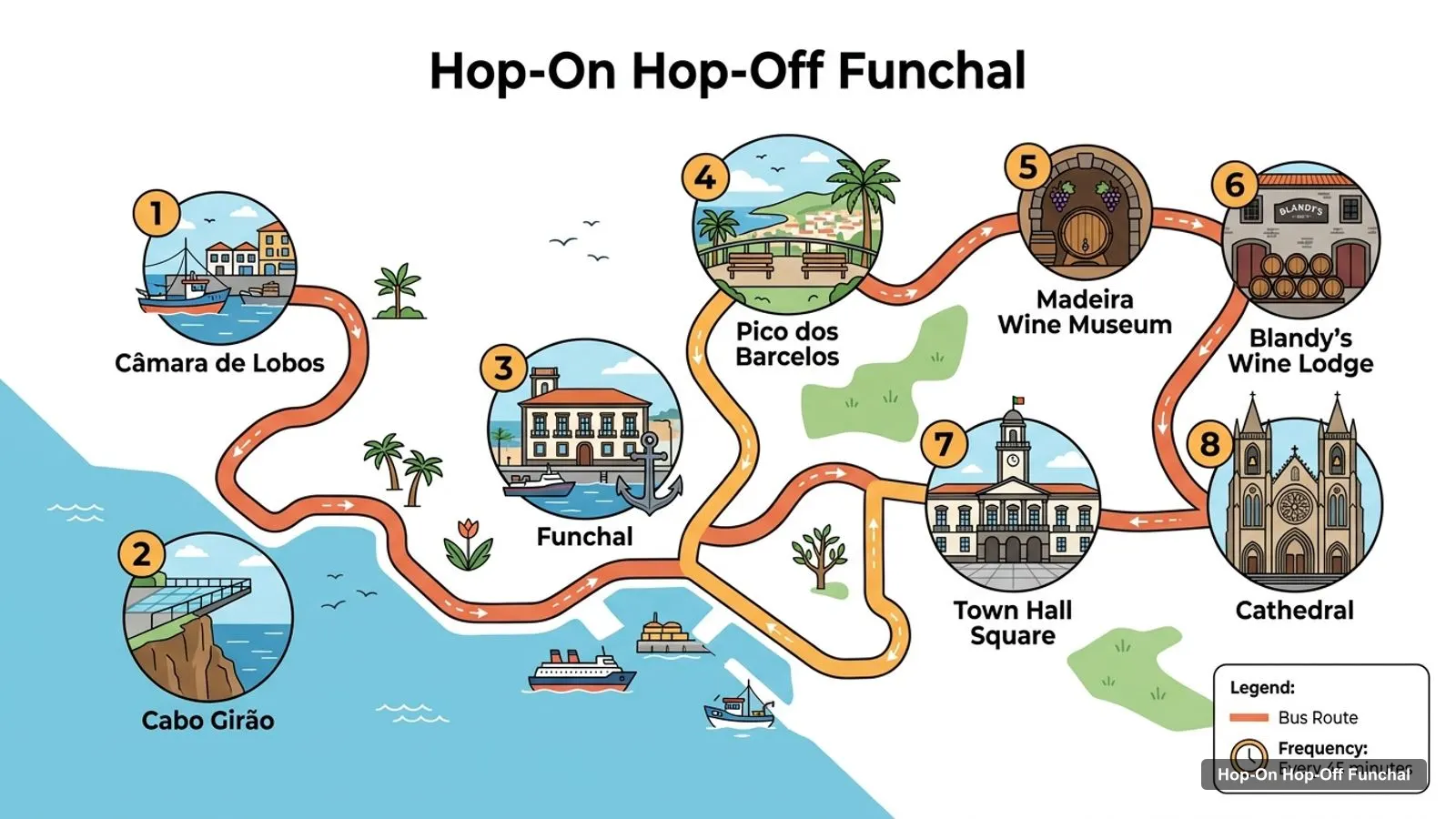
The Funchal sightseeing map below is the Yellow Bus route as listed on GetYourGuide. It runs every 45 minutes, starts at Avenida do Mar by the marina, and the listing talks about up to 30 stops. These are the eight highlights it names.
The numbers are only a list order, not the order the bus visits them. Cabo Girão is reached by a shuttle from Câmara de Lobos on the 3 in 1 option, and the viewpoint fee is not included. The Yellow Bus card is on my Yellow Bus Tours page.
City Sightseeing Red Route stops
The Red Route has 21 stops and takes 100 minutes without hopping off. A bus runs every 25 minutes, with the first leaving Stop 1 at 9:30am and the last at 5:05pm. The Blue Route is a separate 12-stop loop for the 48-hour ticket, and it goes up to Monte every 90 minutes.
The third ticket, the Yellow Bus plus catamaran combo, lists 30 stops with its own names, such as Funchal City Gates, Old Town and Cable Car, the Farmer’s Market and the Cruise Terminal at Stop 29. It runs every 30 minutes from 9am to 12:30pm and every 45 minutes from 1:15pm to 5pm.
Madeira Attractions Things to Do: Top 20 Sights with Coordinates
These are the top Funchal-area sights ranked by Google Maps reviews, with exact coordinates. I left out tour operators, a bus stop pin and places far from the city, such as the Whale Museum in Caniçal. Each link opens the place in Google Maps.
The Funchal Portugal map splits into four clusters, and knowing them saves you time on a hilly coast.
The old town and marina. Praça do Povo, the Cathedral (about 170 metres away), the Jardim Municipal (about 370), the Zona Histórica (about 410), the Madeira Story Centre (about 530) and Parque de Santa Catarina (about 570) all sit within roughly 600 metres of Praça do Povo. This is the one cluster I would walk.
Monte. The Monte Palace garden, the Carreiros do Monte and the cable car pin are within about 190 metres of each other, around 3.3 km from Praça do Povo. The Botanical Garden is about 1.6 km from the Monte Palace garden.
The west coast. Pico dos Barcelos is about 3.2 km west of Praça do Povo, Jardim Panorâmico about 3.1 km, and Cabo Girão about 9.1 km.
The east. Palheiro Gardens is about 4.1 km east, past Forte de São Tiago, and no stop list here names it.
Which Stop for Which Sight on the Funchal Tourist Map
Match the sight to the stop before you board, because the three tickets stop in different places.
Praça do Povo and the Cathedral: City Sightseeing Stop 2 for the square; for the Cathedral, the Yellow Bus list and combo Stop 7.
Town Hall Square: the Yellow Bus list, City Sightseeing’s Câmara Municipal (Stop 6) and the combo’s Madeira Wine Museum and City Hall stop.
Pico dos Barcelos: all three tickets, at Red Route Stop 10.
The cable car: City Sightseeing’s Teleférico (Stop 3) and the combo’s Old Town and Cable Car (Stop 3).
Monte: the Blue Route on City Sightseeing’s 48-hour ticket.
Cabo Girão: the Yellow Bus 3 in 1 option only.
Two sights on the map have no stop with their name on any list: the Botanical Garden and the CR7 Museum. For the museum, City Sightseeing sells a 48-hour ticket that includes entry, and the listing gives the hours as 10am to 5pm, Monday to Friday. The museum is about 600 metres from Praça do Povo, so it is an easy walk from Stop 2 if you start from the marina. The Botanical Garden is further up the hill, and I would reach it from Monte rather than from the old town.
Funchal Tourist Map PDF and Free Download
I don’t have an official Funchal tourist map PDF in my data, so I can’t point you to a download I haven’t checked. Instead, open the Google Maps links in the tables above and save them to a list, which works offline if you download the area in the app. City Sightseeing riders mention being given a map on the bus, so ask for one at Stop 1.
Funchal Tourist Information
For official information on events, opening times and transport, I’d check Visit Madeira. For bus timings, remember that Yellow Bus reviewers say times are not posted at every stop, so note the next departure when you get off. On the Blue Route, with a bus only every 90 minutes, this matters even more.
Funchal Tourist Map Walking Tips
A good rule on this map is to pair every bus ride with one walk. Ride to Pico dos Barcelos, walk the viewpoint, and ride back. Ride to Monte, walk between the garden, the toboggan association and the cable car, which are all within about 190 metres of each other. Spend your walking time in the old town, where Praça do Povo, the Cathedral, the Jardim Municipal and the Zona Histórica all sit within about 410 metres of Praça do Povo, and save your legs for the hills.
The old town is flat and quick, but the hills start almost at once. Allow longer than the distances suggest, and use the bus or cable car for Monte, Pico dos Barcelos and Cabo Girão. Wheelchair users should know that the City Sightseeing listing marks its tour as wheelchair accessible, but I would confirm the details with the operator.
Which Bus Covers the Most of This Map?
The combo covers the most stops on paper, 30 of them, but City Sightseeing’s two routes together reach the old town, Pico dos Barcelos and Monte. If I had to choose one ticket for the map as a whole, I’d choose the 48-hour City Sightseeing ticket for its Monte stops, and add the Yellow Bus on another day for the coast. You can read both on my Funchal itinerary, and compare all three on Funchal hop-on hop-off tickets compared.
I don't have an official PDF in my data, so I built the tables on this page instead. Every sight and stop has a Google Maps link, and you can save them to a list on your phone. One City Sightseeing reviewer mentioned that a paper map is handed out on the bus, so ask for one at Stop 1.
Where do the Funchal sightseeing buses start?+
All three tickets start at Avenida do Mar by the marina. The Yellow Bus meeting point is Avenida do Mar, Funchal Marina, and City Sightseeing's Stop 1 is Avenida do Mar - Marina. The combo with the catamaran lists Stop 1 near the marina, and the catamaran kiosk is in front of its Stop 2.
How many bus stops are there in Funchal?+
It depends on the operator. City Sightseeing's Red Route has 21 stops and its Blue Route 12 listed stops. The Yellow Bus listing mentions up to 30 stops, and the combo lists all 30 by name. On this page I list the eight Yellow Bus highlights and all 21 Red Route stops.
Which Funchal sights are closest together?+
In the old town, Praça do Povo, the Cathedral, the Jardim Municipal and the Zona Histórica are all within about 410 metres of Praça do Povo. In Monte, the Monte Palace garden, the Carreiros do Monte and the cable car pin are within about 190 metres of each other.
Is Funchal walkable?+
The old town and marina are walkable, with the main sights within about 600 metres of Praça do Povo. The sights in Monte, at Pico dos Barcelos and at Cabo Girão are 3 to 9 kilometres away in a straight line, so use the bus or cable car for those.
Where can I get Funchal tourist information?+
Visit Madeira, at visitmadeira.com, is the official tourism site for the island. The Funchal city council also publishes local information. For stop times, check the operator's board at each stop, because reviewers say times are not posted at every Yellow Bus stop.
Tours I compared in Funchal
My full review of each one, in the order I rank them:
 Night tour