Copenhagen Tourist Map: Top Attractions & Bus Stops
By Jake Dawson · Updated · Affiliate links, explained in my disclosure
Tours & Tickets
Copenhagen: Hop-On Hop-Off Bus Tour with Boat Tour Option
4.0 (4,990) · from $33.78
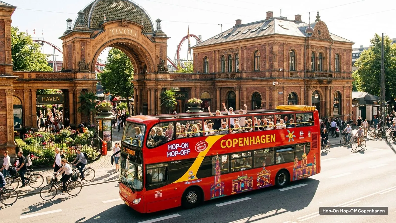
A Copenhagen tourist map makes more sense once you see the city as four clusters around a harbour. I’ve put the top 20 attractions (ranked by Google Maps reviews) and the first 12 sightseeing bus stops on one page, with coordinates and a Google Maps link for each. The route image follows the RED Sightseeing route. To pick the ticket that rides it, see my comparison of hop-on hop-off in Copenhagen.
Copenhagen Tourism Map: The Bus Route
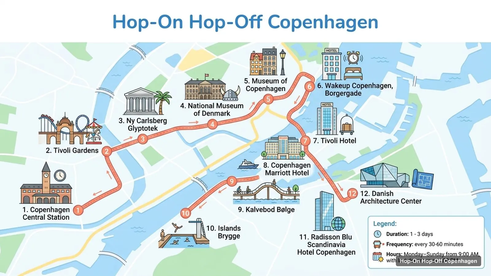
The Copenhagen tourism map below shows the RED Sightseeing route, which starts at Copenhagen Central Station and runs through 25 stops in my data. The ticket lasts 24, 48 or 72 hours, buses run every 30 to 60 minutes, and the first leaves at 9:00 with the last departure at 4:00pm. City Sightseeing and Stromma run three coloured lines (Red, Green and Purple) from a different set of stops, so I list those below the table as well.
Stops on the route
- 1Copenhagen Central Station
- 2Tivoli Gardens
- 3Ny Carlsberg Glyptotek
- 4National Museum of Denmark
- 5Museum of Copenhagen
- 6Wakeup Copenhagen, Borgergade
- 7Tivoli Hotel
- 8Copenhagen Marriott Hotel
- 9Kalvebod Bølge
- 10Islands Brygge
- 11Radisson Blu Scandinavia Hotel Copenhagen
- 12Danish Architecture Center
Bus stops on the RED route
| # | Stop | Map |
|---|---|---|
| 1 | Copenhagen Central Station | Find on Google Maps |
| 2 | Tivoli Gardens | Find on Google Maps |
| 3 | Ny Carlsberg Glyptotek | Find on Google Maps |
| 4 | National Museum of Denmark | Find on Google Maps |
| 5 | Museum of Copenhagen | Find on Google Maps |
| 6 | Wakeup Copenhagen, Borgergade | Find on Google Maps |
| 7 | Tivoli Hotel | Find on Google Maps |
| 8 | Copenhagen Marriott Hotel | Find on Google Maps |
| 9 | Kalvebod Bølge | Find on Google Maps |
| 10 | Islands Brygge | Find on Google Maps |
| 11 | Radisson Blu Scandinavia Hotel Copenhagen | Find on Google Maps |
| 12 | Danish Architecture Center | Find on Google Maps |
The full RED route continues past Christianshavns Torv, Freetown Christiania and Christiansborg Palace to Nyhavn, Amalienborg Palace, Gefion Fountain, Designmuseum Danmark and Kastellet. City Sightseeing has 25 stops of its own, from Ved Stranden and Nyhavn to Rosenborg Castle, Tivoli, Home of Carlsberg and Copenhill. The table above is the core stretch most visitors ride first. Several of the early stops are hotels, such as the Tivoli Hotel, the Copenhagen Marriott and the Radisson Blu Scandinavia, which is how the operator marks the stops near Tivoli and the station. If you’re staying at one of them, that’s your boarding point. Otherwise I’d board at Tivoli or at Nyhavn, which are about 1.6 km apart, and ride in whichever direction the queue is shorter.
Copenhagen Tour Map: Top 20 Sights with Coordinates
This is the Copenhagen tour map in table form, ranked by Google Maps reviews, with exact coordinates. Each link opens the place in Google Maps, where you can save it to a list before you travel. The coordinates are the ones Google Maps returns for each place, so you can paste them into any navigation app. The ratings run from 4.1 for the Little Mermaid to 4.7 for Nyhavn and Louisiana, and the review counts tell you how crowded each place tends to be: Tivoli has 94,510 against 15,242 for the Glyptotek. Louisiana Museum of Modern Art is the one place in the top 20 outside the city: it’s in Humlebaek, about 33 km north of Tivoli, so no bus goes there.
| # | Attraction | Coordinates | Google rating | Map |
|---|---|---|---|---|
| 1 | Tivoli Gardens | 55.67366, 12.56823 | 4.5 (94,510) | Open in Google Maps |
| 2 | The Little Mermaid | 55.69286, 12.59928 | 4.1 (40,298) | Open in Google Maps |
| 3 | Amalienborg Palace | 55.68406, 12.59302 | 4.5 (33,122) | Open in Google Maps |
| 4 | Nyhavn | 55.67979, 12.59071 | 4.7 (30,563) | Open in Google Maps |
| 5 | The Round Tower | 55.68135, 12.57573 | 4.5 (28,837) | Open in Google Maps |
| 6 | Rosenborg Castle | 55.68583, 12.57727 | 4.6 (27,665) | Open in Google Maps |
| 7 | Rådhuspladsen | 55.67592, 12.56914 | 4.4 (23,678) | Open in Google Maps |
| 8 | Christiansborg Palace | 55.67632, 12.58033 | 4.6 (22,754) | Open in Google Maps |
| 9 | Kongens Nytorv | 55.68052, 12.58596 | 4.5 (20,406) | Open in Google Maps |
| 10 | Louisiana Museum of Modern Art | 55.96955, 12.54278 | 4.7 (17,833) | Open in Google Maps |
| 11 | Ny Carlsberg Glyptotek | 55.67298, 12.57254 | 4.6 (15,242) | Open in Google Maps |
| 12 | National Museum of Denmark | 55.67450, 12.57464 | 4.5 (14,398) | Open in Google Maps |
| 13 | The King’s Garden | 55.68529, 12.57985 | 4.6 (13,950) | Open in Google Maps |
| 14 | Church of Our Saviour | 55.67294, 12.59421 | 4.6 (10,282) | Open in Google Maps |
| 15 | Designmuseum Danmark | 55.68643, 12.59361 | 4.3 (8,527) | Open in Google Maps |
| 16 | Botanical Garden | 55.68490, 12.57339 | 4.6 (7,892) | Open in Google Maps |
| 17 | SMK – Statens Museum for Kunst | 55.68881, 12.57833 | 4.6 (6,759) | Open in Google Maps |
| 18 | Danish Architecture Center | 55.67229, 12.57893 | 4.3 (4,817) | Open in Google Maps |
| 19 | Guinness World Records Museum | 55.68022, 12.58385 | 3.5 (4,235) | Open in Google Maps |
| 20 | Museum of Natural History | 55.68747, 12.57678 | 4.1 (3,628) | Open in Google Maps |
Copenhagen Travel Map: The Clusters
Read the coordinates above and you’ll see four tight groups on the Copenhagen travel map:
- The centre (around 55.675, 12.575): Tivoli Gardens, City Hall Square, Ny Carlsberg Glyptotek, the National Museum of Denmark and Christiansborg Palace. Tivoli to City Hall Square is about 0.26 km and Tivoli to the Glyptotek about 0.3 km, so you can walk the whole cluster in a morning.
- The harbour front (around 55.680, 12.590): Nyhavn, Kongens Nytorv, Amalienborg Palace and Designmuseum Danmark. Nyhavn to Amalienborg is about 0.5 km, and Amalienborg to the design museum about 0.27 km.
- North of the old town (around 55.685, 12.577): Rosenborg Castle, the King’s Garden, the Botanical Garden and SMK. Rosenborg to the King’s Garden is only about 0.17 km.
- The northern harbour (around 55.692, 12.596): the Little Mermaid, Kastellet and Gefion Fountain. The statue to Kastellet is about 0.35 km, and Nyhavn to the Little Mermaid is about 1.5 km, which is where the bus earns its price.
Distances matter more than they look on a map. Tivoli to the Little Mermaid is about 2.9 km as the crow flies, and Rosenborg to Amalienborg about 1 km, which is why I’d ride the bus along the harbour and walk inside each cluster. Plan one cluster per half day and you won’t waste time crossing the city. My best things to do in Copenhagen guide has what to see at each place, and my Copenhagen itinerary turns the clusters into 1, 2 and 3-day plans.
Copenhagen Sightseeing Map: Which Stop for Which Sight
The Copenhagen sightseeing map gets easier once you know which stop serves which sight. Here’s how the main attractions line up with the stops in the operators’ listings:
- Tivoli Gardens and City Hall Square: Tivoli stops on the RED, City Sightseeing and Stromma lists, and City Sightseeing names the stop as Tivoli and Radisson Collection Royal Hotel. City Hall Square is its own stop on the Stromma and City Sightseeing lists.
- Nyhavn and Kongens Nytorv: Stromma lists the stop as Nyhavn and Kongens Nytorv, and every route in my data stops at Nyhavn.
- Amalienborg Palace: RED and Stromma stop here, and Stromma’s stop is the Marble Church. City Sightseeing’s own Amalienborg and Ofelia Plads stop is listed as currently closed and out of use.
- The Little Mermaid: nearly every route stops here. The three Langelinie stops run on cruise days only, and the Gray Line lists Indiakaj, Langeliniekaj and Oceankaj nearby.
- Rosenborg Castle: City Sightseeing lists the stop as Rosenborg Castle and SMK, and Stromma, Gray Line and the walking-tour ticket stop here too.
- Christianshavn: RED lists Christianshavns Torv and Stromma’s Purple Line lists Christianshavn and Freetown Christiania. The Church of Our Saviour is about 0.8 km from Nyhavn.
The Round Tower and the King’s Garden have no stop of their own in my data. Walk from Rosenborg: the tower is about 0.5 km and the garden about 0.17 km.
Copenhagen Tourist Map Pdf and Printable
If you’re searching for a Copenhagen tourist map PDF, there are three good options. The first is this page, which prints cleanly and has every link you need. The second is the free map that City Sightseeing’s listing says comes with the ticket. The third is a saved Google Maps list: open each link in the table above and tap Save. For official events and opening times, Visit Copenhagen is the tourism board and the source I’d check before you go.
I don’t have a printable PDF of the bus routes to offer, because the operators change their lines by season. The Classic route runs daily all year, while the Green and Purple lines vary. That’s why I’d rely on the map you get with your ticket for the day itself. Use this Copenhagen tourist map for planning at home, and the operator’s map for the day: the bus map shows the live stop names, while mine shows where the sights sit relative to each other. Together they answer the two questions that matter, which stop to get off at and how far it is to walk from there. If a stop is closed, as City Sightseeing says of its Amalienborg stop, the nearest alternative is usually within a few hundred metres.
If you haven’t booked yet, my comparison of hop-on hop-off in Copenhagen has every price, and the homepage lists the other cities I’ve mapped.
Frequently asked questions
Is there a printable Copenhagen tourist map?
This page works as one: the route map image shows the numbered bus stops, and the tables below list the first 12 stops and the top 20 attractions with coordinates. Print the page, or open any Google Maps link to save the places to your phone for offline use. The bus operators also hand out a free map on board.
Where are most Copenhagen attractions on the map?
In four tight groups. Tivoli, City Hall Square, Christiansborg and the museums sit in the centre. Nyhavn, Kongens Nytorv and Amalienborg are on the harbour front. Rosenborg, the King's Garden and the Botanical Garden are in the north of the old town. The Little Mermaid, Kastellet and Gefion Fountain are along the northern harbour.
How far apart are the main Copenhagen sights?
Tivoli to Nyhavn is about 1.6 km as the crow flies, and Nyhavn to the Little Mermaid is about 1.5 km. Tivoli to the Little Mermaid is about 2.9 km. Nyhavn to Amalienborg is only about 0.5 km, and Tivoli to City Hall Square about 0.26 km, so most of the centre is walkable.
Tours I compared in Copenhagen
My full review of each one, in the order I rank them:
- Copenhagen: Hop-On Hop-Off Bus Tour with Boat Tour Option★ 4.0 · from $33.78
- City Sightseeing Hop-On Hop-Off Bus + Optional Boat Add-On★ 4.3 · from $42.79
- Copenhagen: City Card with 40+ Attractions & Hop-On/Off Bus★ 4.2 · from $90.38
- Copenhagen: Hop-On Hop-Off Bus & Netto Boat★ 3.9 · from $32.65
- Copenhagen: Hop On-Hop Off Bus - 3 Lines 1 Ticket★ 4.0 · from $42.03
- Copenhagen: Hop-On Hop-Off Sightseeing Bus Gray Line 24-hour★ 2.9 · from $34.65
- Copenhagen: Hop-On Hop-Off Sightseeing Bus Gray Line 48 Hours★ 3.0 · from $45.94
- Copenhagen: Hop-on Hop-off bus and Tivoli Gardens★ 5.0 · from $55.17
- Copenhagen City Walk w Audioguide & HO-HO Bus Tour Optionfrom $11.26