City Sightseeing South Africa
Cape Town: Hop-On Hop-Off Bus Tour with Optional Cruise
- 4.8 (4,322 reviews)
- 24-hour ticket
- Free cancellation
My pick: Covers all three city routes on this map, from Stop 1 at the aquarium to Constantia, for $26.
By Jake Dawson · Updated · Affiliate links, explained in my disclosure
City Sightseeing South Africa
Cape Town: Hop-On Hop-Off Bus Tour with Optional Cruise
4.8 (4,322) · from $26
A Cape Town tourist map makes more sense once you see the city as a harbour, a city bowl and a mountain in between. I’ve put the top 20 attractions, ranked by Google Maps reviews, and the City Sightseeing boarding points on one page, with coordinates and a Google Maps link for each. The route image shows the Franschhoek Wine Tram stops, the hop-on hop-off route with the longest published stop list in my data. To pick the ticket that rides these routes, see my comparison of hop-on hop-off in Cape Town.
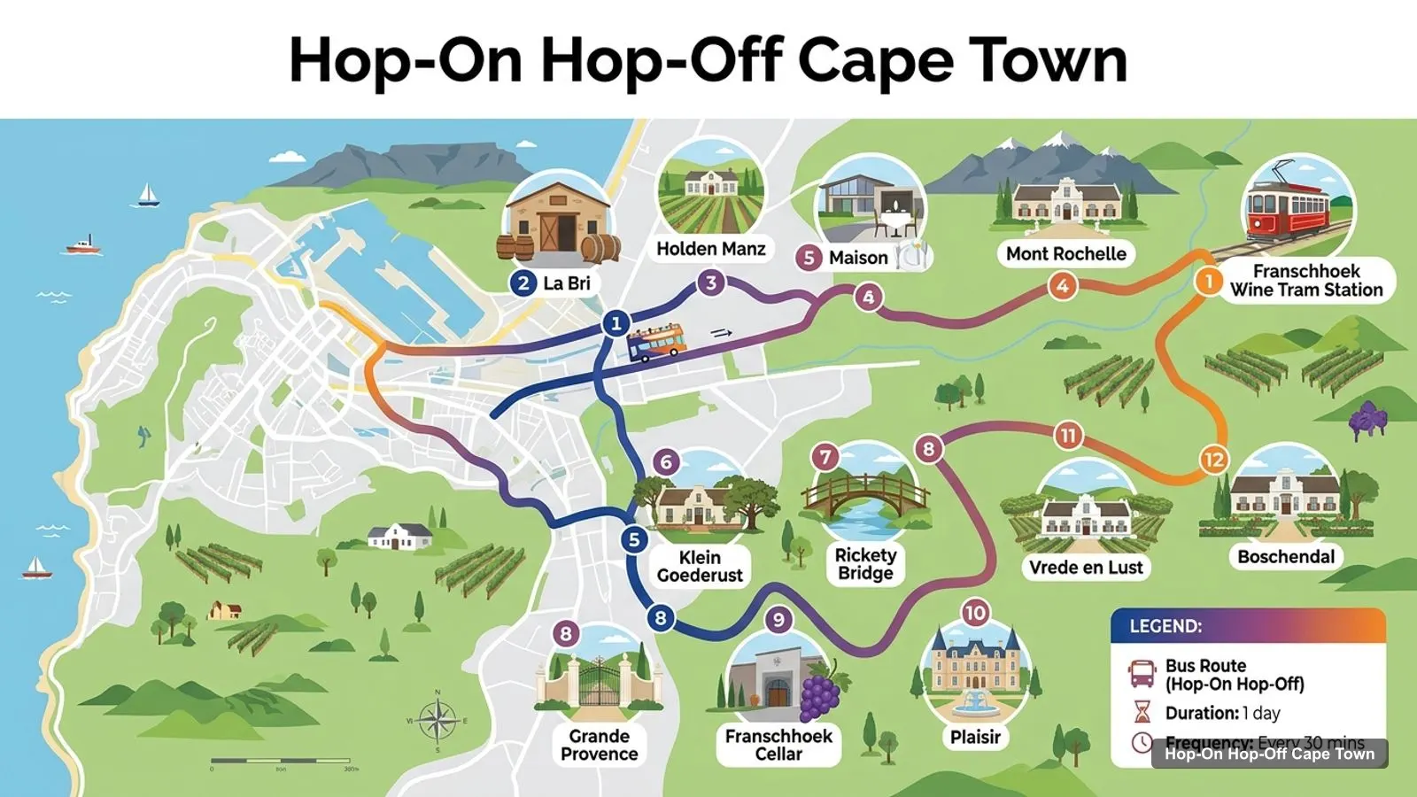
The Cape Town tour map below plots the Franschhoek Wine Tram, the hop-on hop-off route most people add to a Cape Town trip. The tram and open-air tram buses run five colour-coded lines (Blue, Navy, Orange, Pink and Red) from the Franschhoek Wine Tram Station. One transfer listing names 31 estates across them. The image shows 12 of those stops, in the order the operator lists them.
Stops on the route
| # | Wine tram stop | Map |
|---|---|---|
| 1 | Franschhoek Wine Tram Station | Find on Google Maps |
| 2 | La Bri | Find on Google Maps |
| 3 | Holden Manz | Find on Google Maps |
| 4 | Mont Rochelle | Find on Google Maps |
| 5 | Maison | Find on Google Maps |
| 6 | Klein Goederust | Find on Google Maps |
| 7 | Rickety Bridge | Find on Google Maps |
| 8 | Grande Provence | Find on Google Maps |
| 9 | Franschhoek Cellar | Find on Google Maps |
| 10 | Plaisir | Find on Google Maps |
| 11 | Vrede en Lust | Find on Google Maps |
| 12 | Boschendal | Find on Google Maps |
Which line you ride decides which estates you see. The Blue Line runs stops 2 to 9 above, from La Bri to Franschhoek Cellar. The Navy Line starts at Plaisir, Vrede en Lust and Boschendal, then continues to Allée Bleue, Camberley, Bartinney, Le Pommier and Zorgvliet. The Orange Line visits Boschendal, Plaisir, Noble Hill, Babylonstoren, Baccō, Anura and Vrede en Lust. Pink and Red share Rickety Bridge, Grande Provence and Franschhoek Cellar before splitting. You can reach the tram from Cape Town with City Sightseeing’s return transfer, rated 4.64 from 2,478 reviews.
The Cape Town sightseeing map for the city itself is the City Sightseeing network: the Red City route (about 1.5 hours), the Blue Mini Peninsula route (about 2 hours) and the Purple wine route (about 30 minutes). Buses leave every 15 or 30 minutes depending on the season. The operator doesn’t publish a full stop list on its GetYourGuide listings. These are the boarding points I could pin down on Google Maps, plus the stop numbers the listings name: Stop 1 on Dock Road, Stop 5 at 81 Long Street and Stop 21 at Constantia Nek.
| Boarding point | Address | Coordinates | Map |
|---|---|---|---|
| Stop 1: City Sightseeing ticket office | Ticket Office outside the Aquarium, Dock Rd, Victoria & Alfred Waterfront, Cape Town, 8005, South Africa | -33.90765, 18.41753 | Open in Google Maps |
| Stop 5: City Sightseeing Downtown Tour Office | 81 Long St, Cape Town City Centre, Cape Town, 8000, South Africa | -33.92196, 18.41978 | Open in Google Maps |
| City Sightseeing, Sea Point | M6 St Johns Rd, Sea Point, Cape Town, 8060, South Africa | -33.91735, 18.38623 | Open in Google Maps |
| CitySightseeing CTICC Bus Stop | Walter Sisulu Ave, Foreshore, Cape Town, 8000, South Africa | -33.91598, 18.42636 | Open in Google Maps |
| City Sightseeing Stop outside Hotel Sky | 9 Lower Long St, Cape Town City Centre, Cape Town, 8005, South Africa | -33.91632, 18.42596 | Open in Google Maps |
The first row is Stop 1, next to the Two Oceans Aquarium, and the second is Stop 5 on Long Street, where the walking tours start. City Sightseeing says its stops are spread through the city, Sea Point and Camps Bay. One listing says there are more than 30 stops across four routes.
These are the Cape Town tourist attractions in table form, ranked by Google Maps reviews, with exact coordinates. Each link opens the place in Google Maps, so you can build your own Cape Town tourist map in a saved list before you travel. Bus companies and ticket offices are left out.
| # | Attraction | Coordinates | Google rating | Map |
|---|---|---|---|---|
| 1 | V&A Waterfront | -33.90799, 18.42016 | 4.6 (110,970) | Open in Google Maps |
| 2 | Kirstenbosch National Botanical Garden | -33.98750, 18.43272 | 4.8 (34,614) | Open in Google Maps |
| 3 | Boulders Beach | -34.19562, 18.45036 | 4.6 (29,089) | Open in Google Maps |
| 4 | Two Oceans Aquarium | -33.90803, 18.41766 | 4.6 (25,388) | Open in Google Maps |
| 5 | Castle of Good Hope | -33.92605, 18.42806 | 4.3 (13,158) | Open in Google Maps |
| 6 | Green Point Park | -33.90411, 18.40110 | 4.7 (12,865) | Open in Google Maps |
| 7 | The Cape Wheel | -33.90262, 18.41939 | 4.5 (10,603) | Open in Google Maps |
| 8 | Iziko Bo-Kaap Museum | -33.92153, 18.41499 | 4.3 (6,730) | Open in Google Maps |
| 9 | The Nelson Mandela Gateway To Robben Island | -33.90649, 18.42240 | 4.4 (6,095) | Open in Google Maps |
| 10 | Zeitz Museum of Contemporary Art Africa | -33.90841, 18.42264 | 4.4 (5,641) | Open in Google Maps |
| 11 | Lion’s Head Hiking Trail | -33.93682, 18.39484 | 4.8 (3,139) | Open in Google Maps |
| 12 | District Six Museum | -33.92772, 18.42368 | 4.4 (2,667) | Open in Google Maps |
| 13 | Big Bay Cape Town | -33.79243, 18.45692 | 4.6 (1,868) | Open in Google Maps |
| 14 | Cape Town Science Centre | -33.93836, 18.46407 | 4.3 (1,859) | Open in Google Maps |
| 15 | Museum of Illusions Cape Town | -33.92769, 18.41287 | 4.7 (1,833) | Open in Google Maps |
| 16 | Norval Foundation Art Museum | -34.07648, 18.42879 | 4.6 (1,733) | Open in Google Maps |
| 17 | Cape Town Diamond Museum | -33.90712, 18.42247 | 4.8 (1,180) | Open in Google Maps |
| 18 | South African National Gallery | -33.92902, 18.41722 | 4.4 (1,056) | Open in Google Maps |
| 19 | Deer Park | -33.94742, 18.42092 | 4.7 (967) | Open in Google Maps |
| 20 | Iziko Slave Lodge | -33.92489, 18.42050 | 4.5 (950) | Open in Google Maps |
Read the coordinates above and you’ll see the Cape Town travel map split into clear groups:
Plan one cluster of this Cape Town tourist map per half day and you won’t waste time crossing the city. My best things to do in Cape Town guide has what to see at each place. My Cape Town itinerary turns the clusters into 1, 2 and 3-day plans.
The Cape Town tourist map gets easier once you know which stop serves which sight. Here’s how the main attractions line up with the boarding points in my data:
My short Cape Town tourist guide for using this map is to do the Waterfront and city centre on foot, use the bus for the mountain and the coast, and use a car or tour for anything south of Kirstenbosch. The two big clusters are about 1.6 km apart, Stop 1 to Stop 5, which is a walk on a fine day or one bus ride. Some straight-line distances from the Waterfront help with planning. Green Point Park is about 1.8 km away, the Iziko Bo-Kaap Museum about 1.6 km, the Castle of Good Hope about 2.1 km and the Museum of Illusions on Kloof Street about 2.3 km. Lion’s Head is about 4 km away and Kirstenbosch about 9 km. Anything under 2 km is a comfortable walk on a calm day. Anything past that, or uphill toward the mountain, is where the bus earns its price. For the city’s own public buses and routes, the official source is MyCiTi.
If you want a Cape Town tourist map PDF, use your browser’s Print to PDF option on this page. The route image and the three tables fit on a few sheets, and the Google Maps links stay clickable on a phone or tablet. I’d also save the 20 attractions to a starred list in Google Maps. It takes two minutes with the links above, and the list works offline once you download the area.
City Sightseeing is the only city bus operator on this Cape Town tourist map, so the question is which ticket. The $26 City Sightseeing pass covers the Red, Blue and Purple routes, and it’s rated 4.78 from 4,322 reviews. If you want the bus tour I’d book in Cape Town for this map, it’s in my Cape Town sightseeing bus comparison, and the rest of my city maps start from the homepage.
City Sightseeing South Africa
My pick: Covers all three city routes on this map, from Stop 1 at the aquarium to Constantia, for $26.
This page works as one. The route image shows the Franschhoek Wine Tram stops, and the tables list the top 20 attractions and the City Sightseeing boarding points with coordinates. Print the page or save it as a PDF, or open any Google Maps link to save the places to your phone for offline use.
In two tight clusters and a few outliers. The V&A Waterfront has the aquarium, the Cape Wheel, Zeitz MOCAA, the Diamond Museum and the Robben Island gateway, all within 600 m of Stop 1. The city centre around Long Street has the Bo-Kaap, the Castle, District Six and the Iziko museums. Kirstenbosch and Boulders Beach are further south.
The V&A Waterfront and the Castle of Good Hope are about 2.1 km apart in a straight line. Kirstenbosch is about 9 km south of the Waterfront, behind Table Mountain, and Boulders Beach is about 32 km away in Simon's Town. Stop 1 at the Waterfront and Stop 5 on Long Street are about 1.6 km apart.
My full review of each one, in the order I rank them: