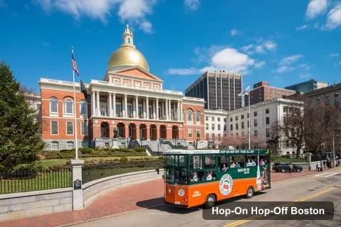
Historic Tours of America - Boston
Boston: Hop-on Hop-off Old Town Trolley Tour
- 4.5 (2,382 reviews)
- 2-day ticket
My pick: Covers the most of this map: 13 stops from the aquarium to Trinity Church.
By Jake Dawson · Updated · Affiliate links, explained in my disclosure
Historic Tours of America - Boston
Boston: Hop-on Hop-off Old Town Trolley Tour
4.5 (2,382) · from $51.45
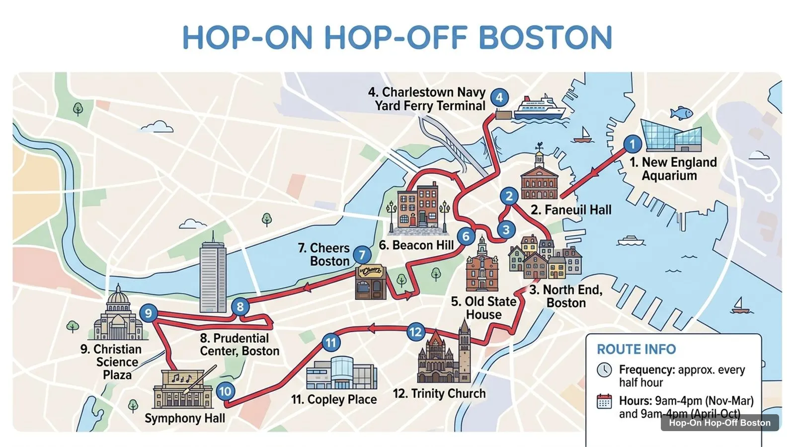
A Boston tourist map makes more sense once you see the city as four clusters around the harbour. I’ve put the top 20 attractions, ranked by Google Maps reviews, and the trolley’s stops on one page, with coordinates and a Google Maps link for each. The route image follows the Old Town Trolley’s stop order. To pick the ticket that rides it, see my comparison of hop-on hop-off in Boston.
The Boston tour map below shows the Old Town Trolley’s main stops: the New England Aquarium and Faneuil Hall, the North End, the Charlestown Navy Yard, the Old State House, Beacon Hill and Cheers, then the Back Bay stops from the Prudential Center to Trinity Church. The trolley runs about every 30 minutes, with last departures at 4 PM from Stop 1 and 4:15 PM from Stop 7.
Stops on the route
| # | Stop | Map |
|---|---|---|
| 1 | New England Aquarium | Find on Google Maps |
| 2 | Faneuil Hall | Find on Google Maps |
| 3 | North End, Boston | Find on Google Maps |
| 4 | Charlestown Navy Yard Ferry Terminal | Find on Google Maps |
| 5 | Old State House | Find on Google Maps |
| 6 | Beacon Hill | Find on Google Maps |
| 7 | Cheers Boston | Find on Google Maps |
| 8 | Prudential Center, Boston | Find on Google Maps |
| 9 | Christian Science Plaza | Find on Google Maps |
| 10 | Symphony Hall | Find on Google Maps |
| 11 | Copley Place | Find on Google Maps |
| 12 | Trinity Church | Find on Google Maps |
The numbers above are the order on my route image, not the operator’s stop numbers. The operator numbers 13 stops, with Boston Common as Stop 8 and the Tea Party Ships as Stop 9. Boston Sightseeing runs a separate 8-stop loop: the waterfront at 206 Atlantic Avenue, Old State House, Downtown, Boston Common, Cheers, Boston Public Library, Trinity Church and the Massachusetts State House.
These are the Boston tourist attractions in table form, ranked by Google Maps reviews, with exact coordinates. Each link opens the place in Google Maps, where you can save it to a list before you travel. I left out tour-company listings and the China Trade Gate.
| # | Attraction | Coordinates | Google rating | Map |
|---|---|---|---|---|
| 1 | Faneuil Hall Marketplace | 42.36019, -71.05511 | 4.5 (49,468) | Open in Google Maps |
| 2 | Fenway Park | 42.34668, -71.09722 | 4.8 (46,237) | Open in Google Maps |
| 3 | Boston Common | 42.35509, -71.06573 | 4.7 (39,128) | Open in Google Maps |
| 4 | New England Aquarium | 42.35925, -71.04915 | 4.4 (29,030) | Open in Google Maps |
| 5 | Museum of Science | 42.36771, -71.07098 | 4.7 (23,625) | Open in Google Maps |
| 6 | Museum of Fine Arts, Boston | 42.33938, -71.09405 | 4.8 (20,139) | Open in Google Maps |
| 7 | Public Garden | 42.35406, -71.07009 | 4.8 (18,974) | Open in Google Maps |
| 8 | Boston National Historical Park - Charlestown Navy Yard | 42.37312, -71.05650 | 4.7 (11,378) | Open in Google Maps |
| 9 | Isabella Stewart Gardner Museum | 42.33814, -71.09906 | 4.7 (11,378) | Open in Google Maps |
| 10 | Boston Tea Party Ships & Museum | 42.35218, -71.05129 | 4.6 (9,964) | Open in Google Maps |
| 11 | USS Constitution Museum | 42.37398, -71.05542 | 4.7 (8,550) | Open in Google Maps |
| 12 | Bunker Hill Monument | 42.37635, -71.06078 | 4.7 (7,341) | Open in Google Maps |
| 13 | Boston Children’s Museum | 42.35197, -71.04968 | 4.7 (6,773) | Open in Google Maps |
| 14 | Castle Island | 42.33787, -71.01252 | 4.7 (6,473) | Open in Google Maps |
| 15 | The Harvard Museum of Natural History | 42.37845, -71.11572 | 4.8 (5,814) | Open in Google Maps |
| 16 | The Paul Revere House | 42.36374, -71.05370 | 4.5 (5,056) | Open in Google Maps |
| 17 | Charles River Esplanade | 42.35558, -71.07888 | 4.8 (4,995) | Open in Google Maps |
| 18 | Institute of Contemporary Art | 42.35282, -71.04328 | 4.4 (4,568) | Open in Google Maps |
| 19 | Christopher Columbus Waterfront Park | 42.36099, -71.05163 | 4.7 (4,157) | Open in Google Maps |
| 20 | USS Constitution | 42.37246, -71.05658 | 4.8 (3,596) | Open in Google Maps |
The Boston travel map breaks down into four clusters, and each one suits a different hour of the day.
Waterfront and North End. Faneuil Hall, the New England Aquarium, Christopher Columbus Waterfront Park and the Paul Revere House all sit within about 0.5 km of each other. The aquarium to the Tea Party Ships is about 0.8 km. This is where both operators start, on Atlantic Avenue.
Historic core and the Common. The Old State House and the Boston Massacre Site are about 20 metres apart, and Faneuil Hall is about 0.25 km away. Boston Common is about 0.8 km from the Old State House and about 0.38 km from the Public Garden, and the Massachusetts State House is about 0.44 km from the Common.
Charlestown. The Navy Yard, the USS Constitution Museum and the ship are within 0.2 km of each other, and the Bunker Hill Monument is about 0.5 km away. Only the trolley stops here.
Fenway and the museums. Fenway Park, the Museum of Fine Arts and the Gardner Museum form a line to the west: Fenway to the MFA is about 0.85 km, and the MFA to the Gardner about 0.43 km. No tour stops here.
If you want a sight, here is the stop to use. This is the Boston tourist attractions map in words.
| Sight | Trolley stop | Boston Sightseeing stop |
|---|---|---|
| Faneuil Hall and the aquarium | Stop 1 | Stop 1 area |
| Paul Revere House | Stop 2, Historic North End | Not on the route |
| Navy Yard and USS Constitution | Stop 3 | Not on the route |
| Old State House | Stop 5 | Stop 2 |
| Boston Common | Stop 8 | Stop 4 |
| Tea Party Ships and Children’s Museum | Stop 9 | Not on the route |
| View Boston | Stop 10 | Not on the route |
| Trinity Church | Stop 13 | Stop 7 |
| Massachusetts State House | Pass-by | Stop 8 |
The Boston sightseeing map is mostly a walking map. The historic core is compact: Faneuil Hall to Boston Common is about 1.0 km in a straight line, so walking is often faster than waiting for a half-hourly bus. I’d ride for the long legs (to Charlestown, which is about 1.4 km from Faneuil Hall, and to Back Bay) and walk the short ones.
For the places no tour reaches, the MBTA subway is $2.40 a ride and a 1-day pass $11.00, according to the MBTA fares page, checked October 2026. For the history, the National Park Service page for Boston National Historical Park lists the sites it manages, and the Freedom Trail Foundation describes the 2.5-mile trail between 16 historic sites.
A Boston tourist guide is only useful if the hours match your day, so here are the ones Google Maps lists for the places on the map. Boston Common is open 6 AM to 11:30 PM every day, and the Charles River Esplanade 6 AM to 8 PM. The New England Aquarium opens 9 AM to 5 PM on weekdays and until 6 PM on weekends. Faneuil Hall Marketplace is open 10 AM to 9 PM, and from 11 AM to 7 PM on Sunday.
Closing days matter more than opening times. The Museum of Fine Arts, the Gardner Museum, the Children’s Museum and the Institute of Contemporary Art (on Monday) each close for a day, and the Bunker Hill Monument is listed closed on Monday and Tuesday. USS Constitution, the ship itself, is open Wednesday to Sunday from 10 AM to 4 PM. If you build a day from the table above, check the closing day first.
The trolley does not run on Thanksgiving Day, Christmas Day or Patriots Day, according to the operator’s listing. The next US public holiday is Columbus Day on 12 October 2026, so check opening hours for that date.
The trolley’s Green loop touches three of the four clusters in about two hours without stopping: the waterfront, the historic core and Charlestown. The Orange loop adds Back Bay in about 30 minutes. The double-decker keeps to the waterfront, the core and Back Bay, in one loop.
That leaves the museum cluster in the west, which is the one the buses skip. The Museum of Fine Arts is on Huntington Avenue, the same avenue as the trolley’s Christian Science Plaza and Copley Place stops, so you can see which part of the avenue the buses reach. I’d save the museums for a different day, as in my itinerary.
One small detail helps when reading the map: the Old State House and the Boston Massacre Site are only about 20 metres apart, and the trolley’s Stop 5 is on State Street, directly across from the Old State House, so there is no need to walk anywhere to reach it.
The simplest way to use this Boston tourist map is to open the Google Maps links for the five or six sights you care about and save them to a list. Then add the stop you plan to board at, such as 200 Atlantic Avenue for the trolley or 206 Atlantic Avenue for Boston Sightseeing, which are only a few dozen metres apart. With your sights and your stop on one screen, you can see at a glance whether the bus or your feet make more sense for each leg of the day.
The Old Town Trolley covers the most of this map: 13 stops, including Charlestown, the North End, the Tea Party Ships and Back Bay. It costs from $51.45 and is valid for 1 or 2 days.
Historic Tours of America - Boston
My pick: Covers the most of this map: 13 stops from the aquarium to Trinity Church.
For ranked sights with opening hours, see the best things to do in Boston. For a day-by-day plan, use my Boston itinerary for 1, 2 and 3 days. To compare the tickets, go to the hop-on hop-off Boston guide, or return to the homepage.
This page works as one. The route image shows the trolley's stops in order, and the tables list 12 stops and the top 20 attractions with coordinates. Print the page, or open any Google Maps link to save the places to your phone for offline use.
In four clusters. The waterfront has Faneuil Hall, the aquarium and the Tea Party Ships. The historic core has the Old State House, Boston Common and the State House. Charlestown has the Navy Yard and USS Constitution. Fenway and the museums sit to the west, about 2.7 km from the Common.
Faneuil Hall to Boston Common is about 1.0 km in a straight line, and Faneuil Hall to the New England Aquarium about 0.5 km. The Navy Yard in Charlestown is about 1.4 km from Faneuil Hall. Fenway Park is about 2.7 km from the Common, so it needs a subway or bus ride.
The Old Town Trolley stops at the aquarium and Faneuil Hall, the North End, the Navy Yard, the Old State House, Beacon Hill, Boston Common and the Tea Party Ships. Boston Sightseeing covers the Old State House, Boston Common, Cheers, the Public Library and the State House. Fenway Park and the museums are not stops.
My full review of each one, in the order I rank them: