
Big Bus Tours - Athens
Athens: Big Bus Hop-on, Hop-off Tour by Open-Top Bus
- 4.2 (1,606 reviews)
- 3-day ticket
- Free cancellation
My pick: Covers the most of this map: more than 40 stops across the city, Piraeus and the Riviera.
By Jake Dawson · Updated · Affiliate links, explained in my disclosure

City Sightseeing Europe
Athens: City Sightseeing Hop-On Hop-Off Bus Tour
4.3 (5,623) · from $24.77
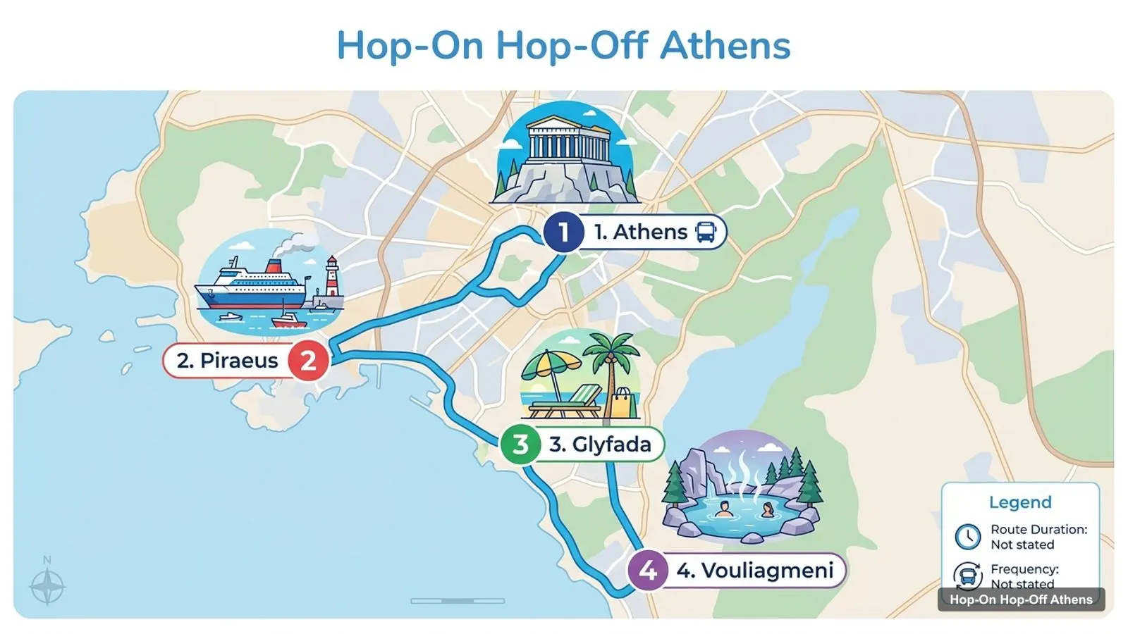
An Athens tourist map is easy to read once you see that nearly everything sits around one hill. I’ve put the top 20 attractions, ranked by Google Maps reviews, and the main sightseeing bus stops on one page, with coordinates and a Google Maps link for each. The route image shows the bus lines from the center out to the port and the beaches. To pick the ticket that rides them, see my comparison of hop-on hop-off in Athens.
All coordinates and ratings come from Google Maps, and the stop lists come from the operators’ listings, checked October 2026. Distances are straight-line, worked out from the coordinates.
The Athens tour map below shows the four Gray Line lines, which reach further than the city loop. The Orange Line runs through central Athens, the Blue Line goes to the Port of Piraeus, the Yellow Line follows the coast to Glyfada, and the Green Line continues to Vouliagmeni. City Sightseeing and Big Bus run the same three areas with a city route, a Piraeus route and a Riviera route.
Stops on the route
| # | Line end | Map |
|---|---|---|
| 1 | Athens | Find on Google Maps |
| 2 | Piraeus | Find on Google Maps |
| 3 | Glyfada | Find on Google Maps |
| 4 | Vouliagmeni | Find on Google Maps |
This is City Sightseeing’s Athens route in stop order. It starts at Syntagma Square, takes 90 minutes for a full loop and runs every 20 to 30 minutes from 8:30am, with the last departure at 6:30pm. Stop 4 is where you change for the Piraeus route.
| Stop | Name | Map |
|---|---|---|
| 1 | Syntagma Square | Find on Google Maps |
| 2 | Acropolis / Plaka | Find on Google Maps |
| 3 | Acropolis Museum | Find on Google Maps |
| 4 | The Acropolis & Parthenon (Interchange: Piraeus route) | Find on Google Maps |
| 5 | Temple of Zeus | Find on Google Maps |
| 6 | Parliament / National Gardens | Find on Google Maps |
| 7 | The Four Museums | Find on Google Maps |
| 8 | The National Gallery | Find on Google Maps |
| 9 | Ancient Olympic Stadium | Find on Google Maps |
| 10 | National Library | Find on Google Maps |
| 11 | National Archaeological Museum | Find on Google Maps |
| 12 | Omonoia Square | Find on Google Maps |
| 13 | Karaiskaki Square | Find on Google Maps |
| 14 | Monastiraki Square | Find on Google Maps |
| 15 | Kotzia Square | Find on Google Maps |
Big Bus’s Red Route follows almost the same order, with the Benaki Museum and the Panathenaic Stadium in the middle. Its staff stand at Stop 1 (1 Ermou Street, in front of the Nike store), Stop 2 (Melina’s statue on Dionysiou Areopagitou), Stop 4 (69 Rovertou Galli Street), Stop 5 (by the Temple of Zeus entrance), Stop 6 (next to Parliament), Stop 10 (Omonia Square) and Stop 13 (Monastiraki Square).
This is the Athens tourist attractions map in table form, ranked by Google Maps reviews, with exact coordinates. Each link opens the place in Google Maps, where you can save it to a list before you travel. I’ve left out the Athens Olympic Museum in Marousi, which is about 9 km from the Acropolis.
| # | Attraction | Coordinates | Google rating | Map |
|---|---|---|---|---|
| 1 | Acropolis of Athens | 37.97153, 23.72575 | 4.8 (148,735) | Open in Google Maps |
| 2 | Parthenon | 37.97153, 23.72672 | 4.8 (87,907) | Open in Google Maps |
| 3 | Acropolis Museum | 37.96845, 23.72852 | 4.7 (85,810) | Open in Google Maps |
| 4 | Athens National Garden | 37.97259, 23.73743 | 4.6 (44,271) | Open in Google Maps |
| 5 | Ancient Agora of Athens | 37.97490, 23.72209 | 4.7 (40,839) | Open in Google Maps |
| 6 | National Archaeological Museum | 37.98902, 23.73276 | 4.6 (39,433) | Open in Google Maps |
| 7 | Temple of Olympian Zeus | 37.96930, 23.73310 | 4.4 (31,975) | Open in Google Maps |
| 8 | Technopolis City of Athens | 37.97823, 23.71365 | 4.5 (18,795) | Open in Google Maps |
| 9 | Odeon of Herodes Atticus | 37.97079, 23.72458 | 4.9 (18,057) | Open in Google Maps |
| 10 | Roman Forum of Athens (Roman Agora) | 37.97425, 23.72610 | 4.5 (15,184) | Open in Google Maps |
| 11 | Temple of Hephaestus | 37.97559, 23.72145 | 4.8 (13,030) | Open in Google Maps |
| 12 | Museum of Illusions Athens | 37.97681, 23.72281 | 4.4 (10,909) | Open in Google Maps |
| 13 | Holy Metropolitan Church of the Annunciation to the Virgin Mary | 37.97538, 23.72985 | 4.7 (10,215) | Open in Google Maps |
| 14 | Benaki Museum | 37.97595, 23.74045 | 4.7 (8,060) | Open in Google Maps |
| 15 | Syntagma Square | 37.97555, 23.73471 | 4.5 (7,175) | Open in Google Maps |
| 16 | Theatre of Dionysus Eleuthereus | 37.97033, 23.72781 | 4.7 (6,809) | Open in Google Maps |
| 17 | Kerameikos Archaeological Site | 37.97803, 23.71727 | 4.4 (6,349) | Open in Google Maps |
| 18 | National Gallery - Alexandros Soutsos Museum | 37.97562, 23.74936 | 4.6 (6,186) | Open in Google Maps |
| 19 | Areopagus Hill | 37.97237, 23.72323 | 4.8 (5,658) | Open in Google Maps |
| 20 | National Museum of Contemporary Art Αthens (ΕΜΣΤ) | 37.96300, 23.72534 | 4.4 (5,469) | Open in Google Maps |
Read the coordinates above and you’ll see three tight groups on the Athens Greece attractions map:
One sight sits apart: the National Archaeological Museum, 1.51 km north of Syntagma Square and 2.04 km from the Acropolis. Plan one cluster per half day and ride to the museum. My best things to do in Athens guide has what to see at each place, and my Athens itinerary turns the clusters into 1, 2 and 3-day plans.
The Athens tourism map gets easier once you know which stop serves which sight. Here’s how the main attractions line up with the bus stops in the operators’ listings:
The Athens travel map stretches to the sea, which is where the bus routes split. City Sightseeing’s Piraeus route runs every 60 minutes between 11am and 5pm and stops at Pantion University, the Niarchos Foundation, the Municipal Theatre, the cruise terminals, the Archaeological Museum of Piraeus, Votsalakia Beach and Mikrolimano harbor. Its Beach-Riviera route runs every 60 minutes between 9am and 5pm, takes 110 minutes and reaches Vouliagmeni Lake and Glyfada. Big Bus’s Green Route covers Flisvos and Alimos marinas, Kavouri and Astir beaches, Vouliagmeni Lake and Glyfada. The coastal buses run hourly, so check the last return time before you hop off at a beach.
If you’re arriving by ship, read the Athens tourist map from the bottom up. All three bus companies stop at the Piraeus cruise terminals: City Sightseeing lists Cruise Terminals A and B, and Big Bus lists Cruise Terminal A and Cruise Terminals B and C. The Piraeus route brings you to the Acropolis, the interchange for the city loop. From there, the Acropolis, the Acropolis Museum and the Ancient Agora are all within 0.5 km, so a short cruise day can stay inside the first cluster on this Athens tourist map. Leave a full bus loop of margin for the ride back to the port.
If you want a printable Athens tourist map, print this page as it is. The route image and the three tables fit on a few sheets and keep the stop numbers next to the sights. For a PDF, use your browser’s “Print to PDF” option, which keeps the Google Maps links clickable on a phone. I’d also save the 20 attractions to a starred list in Google Maps: it takes two minutes with the links above, and the list works offline.
Several bus stops share a name with an Athens metro station, which helps if you switch between the two. Syntagma, Monastiraki, Omonia and Acropolis are all metro stations as well as bus stops, so you can ride the bus one way and take the metro back. For metro lines, fares and timetables, the city’s transport authority OASA has the current information. If you’re walking instead, follow Dionysiou Areopagitou, the pedestrian street under the Acropolis, from the Acropolis Museum to Thissio and the Ancient Agora.
On this Athens tourist map, Big Bus lists the most stops in my data, more than 40 across its three routes, and the cheapest ticket to reach all four directions is the Gray Line pass at $13.51 for two days. For the best-rated city loop, City Sightseeing scores 4.33 from 5,623 reviews and names 7 of the top 15 sights as stops. If you want the bus tour I’d book in Athens for this map, it’s on my Athens sightseeing bus comparison, and the rest of my city maps start from the homepage.
Big Bus Tours - Athens
My pick: Covers the most of this map: more than 40 stops across the city, Piraeus and the Riviera.
This page works as one. The route map image shows the four sightseeing bus lines out to Piraeus, Glyfada and Vouliagmeni, and the tables below list the 15 city-route bus stops and the top 20 attractions with coordinates. Print the page, or open the Google Maps links to save the places to your phone for offline use.
In three clusters within about 1 km of each other. The Acropolis cluster has the Parthenon, the Acropolis Museum and the Odeon of Herodes Atticus. The Monastiraki cluster has the Ancient Agora, the Temple of Hephaestus and the Roman Agora. The Syntagma cluster has Parliament, the National Garden and the Benaki Museum.
Closer than in most capitals. Syntagma Square is about 0.9 km from the Acropolis, and the Ancient Agora is about 0.5 km from it. The Acropolis Museum is about 0.4 km from the Acropolis entrance. The big exception is the National Archaeological Museum, about 2 km north of the Acropolis, which is where a bus saves the most time.
Yes, on the bus map. City Sightseeing, Big Bus and Gray Line all run a separate Piraeus route that links the Acropolis with the cruise terminals, the Pasalimani marina and Mikrolimano harbor. City Sightseeing's Piraeus route runs every 60 minutes between 11am and 5pm and takes 80 minutes.
My full review of each one, in the order I rank them: