Tours & Tickets
Amsterdam: Hop-On Hop-Off Bus and Boat
- 3.9 (6,487 reviews)
- 2-day ticket
- Free cancellation
My pick: Covers the most of this map: 10 bus stops and 8 boat stops on one pass.
By Jake Dawson · Updated · Affiliate links, explained in my disclosure
An Amsterdam tourist map makes more sense once you see the city as four clusters around the canal ring. I’ve put the top 20 attractions, ranked by Google Maps reviews, and the sightseeing bus and canal boat stops on one page, with coordinates and a Google Maps link for each. To pick the ticket that rides these routes, see my comparison of hop-on hop-off in Amsterdam.
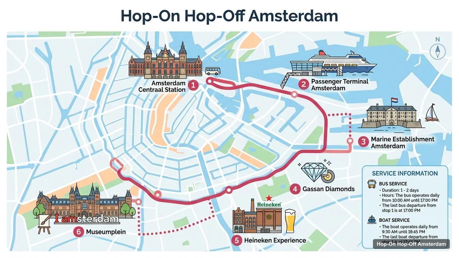
The Amsterdam tour map below shows the stops named on the bus and boat listing, starting at Central Station and running east through the docks before turning south to the Heineken Experience and Museumplein. The bus runs daily from 10am to 5pm and a full loop takes 60 to 75 minutes. The boats run from 9:30am to 7:45pm, with the last departure from stop 1 at 5:45pm.
Stops on the route
| # | Stop | Map |
|---|---|---|
| 1 | Amsterdam Centraal Station | Find on Google Maps |
| 2 | Passenger Terminal Amsterdam | Find on Google Maps |
| 3 | Marine Establishment Amsterdam | Find on Google Maps |
| 4 | Gassan Diamonds | Find on Google Maps |
| 5 | Heineken Experience | Find on Google Maps |
| 6 | Museumplein | Find on Google Maps |
Marine Establishment Amsterdam is the Marineterrein, next to the National Maritime Museum stop. The route image follows the stops named on the bus and boat listing. The bus-only and boat-only listings give a fuller list, which is the next table.
This Amsterdam visitor map table lists the stops in the order the operator’s listings give them. The bus has nine numbered stops plus the Jordaan at the end of its itinerary. The boat has eight. Several share a location, which is where you can switch from bus to boat on the bus and boat ticket.
| # | Bus stop | Boat stop |
|---|---|---|
| 1 | Central Station East (Aloha Bowling) – map | Central Station East (Restaurant Loetje) – map |
| 2 | Passenger Terminal Amsterdam – map | Passenger Terminal Amsterdam – map |
| 3 | National Maritime Museum – map | National Maritime Museum – map |
| 4 | Gassan Diamonds – map | World of Gassan – map |
| 5 | Royal Theater Carré – map | Waterlooplein (Stopera City Hall) – map |
| 6 | Waterlooplein (Jewish Historical Quarter) – map | Albert Cuyp Market – map |
| 7 | Heineken Experience – map | Rijksmuseum (Museumplein) – map |
| 8 | Museum District (Museumplein) – map | Westermarkt (Anne Frank House) – map |
| 9 | Leidseplein (Vondelpark) – map | – |
| 10 | The Jordaan – map | – |
The shared stops are Central Station East, the Passenger Terminal, the National Maritime Museum, Gassan and Waterlooplein. Museumplein has both a bus stop (Museum District) and a boat stop (Rijksmuseum). Reviewers say several stops are poorly signed, so look for the red City Sightseeing stop sign or check the free City Sightseeing Amsterdam app, which shows every stop and tracks the buses live.
This is the Amsterdam sites map in table form, ranked by Google Maps reviews, with exact coordinates. Each link opens the place in Google Maps, where you can save it to a list before you travel.
| # | Attraction | Coordinates | Google rating | Map |
|---|---|---|---|---|
| 1 | Rijksmuseum | 52.36000, 4.88522 | 4.7 (116,296) | Open in Google Maps |
| 2 | Van Gogh Museum | 52.35808, 4.88121 | 4.6 (109,993) | Open in Google Maps |
| 3 | Anne Frank House | 52.37522, 4.88398 | 4.5 (76,556) | Open in Google Maps |
| 4 | Vondelpark | 52.35799, 4.86865 | 4.7 (61,478) | Open in Google Maps |
| 5 | NEMO Science Museum | 52.37417, 4.91233 | 4.5 (37,977) | Open in Google Maps |
| 6 | ARTIS | 52.36600, 4.91653 | 4.5 (37,334) | Open in Google Maps |
| 7 | Madame Tussauds Amsterdam | 52.37259, 4.89258 | 4.3 (33,000) | Open in Google Maps |
| 8 | A’DAM Lookout | 52.38396, 4.90211 | 4.6 (30,968) | Open in Google Maps |
| 9 | Moco Museum | 52.35874, 4.88191 | 4.2 (28,711) | Open in Google Maps |
| 10 | Royal Palace Amsterdam | 52.37318, 4.89138 | 4.6 (27,020) | Open in Google Maps |
| 11 | The 9 Streets | 52.37020, 4.88605 | 4.5 (16,142) | Open in Google Maps |
| 12 | Stedelijk Museum Amsterdam | 52.35801, 4.87976 | 4.4 (15,649) | Open in Google Maps |
| 13 | Rembrandt House Museum | 52.36937, 4.90123 | 4.5 (15,429) | Open in Google Maps |
| 14 | Heineken Experience | 52.35783, 4.89182 | 4.2 (14,994) | Open in Google Maps |
| 15 | Dungeon Amsterdam | 52.37016, 4.89211 | 4.5 (14,246) | Open in Google Maps |
| 16 | National Maritime Museum | 52.37156, 4.91438 | 4.5 (13,586) | Open in Google Maps |
| 17 | This is Holland | 52.38419, 4.90220 | 4.7 (12,104) | Open in Google Maps |
| 18 | Ripley’s Believe It or Not! | 52.37240, 4.89357 | 4.4 (12,015) | Open in Google Maps |
| 19 | The Upside Down Amsterdam | 52.33987, 4.89307 | 4.6 (11,827) | Open in Google Maps |
| 20 | Eye Film Museum | 52.38435, 4.90128 | 4.4 (11,361) | Open in Google Maps |
Read the coordinates above and you’ll see four groups on the Amsterdam sightseeing map:
The gaps between clusters are where a bus or boat earns its price: the Rijksmuseum is about 1.7 km from the Anne Frank House and about 2.4 km from NEMO. The Upside Down Amsterdam is the outlier, about 2.3 km south of the Rijksmuseum and off every route.
The Amsterdam things to do map gets easier once you know which stop serves which sight:
What to do at each one is in my guide to the best things to do in Amsterdam.
If you want an Amsterdam tourist map PDF, print this page with your browser’s “Save as PDF” option. The route image and the three tables fit on a few sheets and keep the stop numbers next to the sights, and the Google Maps links stay clickable on a phone or tablet. The bus and boat listing also includes a city map with the ticket. I’d also save the 20 attractions to a starred list in Google Maps: it takes two minutes with the links above, and the list works offline once the area is downloaded.
Opening hours change how you should read an Amsterdam tourist map, because the early closers and the late openers sit in different clusters. These are the hours Google Maps lists for the top sights:
So the map works best south to north: Museumplein in the morning, the east around midday, and the old centre and Amsterdam Noord in the evening. The bus stops running at 5pm, but the boats run until 7:45pm, which gets you from Museumplein to Westermarkt for an evening at the Anne Frank House.
The two routes on this map are not the same trip. The bus route covers more ground: it’s the only way to reach the Heineken Experience, Leidseplein and Vondelpark, and the Royal Theater Carré on a hop-on hop-off ticket. A full loop takes 60 to 75 minutes. The boat route is the only one with stops at the Anne Frank House and the Albert Cuyp Market, and it runs more than three hours longer each day. Reviewers on the bus and boat ticket mostly preferred the boats, saying there was more to see up close. If your must-sees are on one route only, the boat-only and bus-only tickets each start at $30.96.
Inside the canal ring, walking is the fastest way between sights in the same cluster. For the longer hops, Amsterdam’s trams and the free IJ ferries are run by GVB, which has route maps and fares. Watch for the red bike lanes when you’re crossing streets with your eyes on a map. My Amsterdam itinerary turns these clusters into 1, 2 and 3-day plans.
The bus and boat ticket covers the most of this Amsterdam tourist map: the bus reaches Museumplein, Vondelpark, the Heineken Experience and the east, and the boat adds the Anne Frank House and the Albert Cuyp Market. If you want the bus tour I’d book in Amsterdam for these routes, it’s on my Amsterdam sightseeing bus comparison, and the rest of my city maps start from the homepage.
Tours & Tickets
My pick: Covers the most of this map: 10 bus stops and 8 boat stops on one pass.
This page works as one: the route image shows the sightseeing stops, and the tables below list the bus and boat stops and the top 20 attractions with coordinates. Print it or save it as a PDF from your browser, and open any Google Maps link to save the places to your phone for offline use.
In four clusters. Museumplein in the south has the Rijksmuseum, Van Gogh Museum, Moco and Stedelijk. The old centre has Dam Square, the Royal Palace and the Anne Frank House. The east has NEMO, the National Maritime Museum and ARTIS. Amsterdam Noord, across the IJ, has A'DAM Lookout and the Eye Film Museum.
The Rijksmuseum and the Anne Frank House are about 1.7 km apart as the crow flies, and the Rijksmuseum and NEMO about 2.4 km. Central Station's bus stop is about 2.9 km from Museumplein. Within each cluster distances are short: the Rijksmuseum and Van Gogh Museum are about 350 metres apart.
Bus stop 1 is at Central Station East, at Aloha Bowling, and boat stop 1 is next to Restaurant Loetje on your left as you leave the station. The tables on this page link every stop to Google Maps, and the free City Sightseeing Amsterdam app shows the stops with live bus tracking.
My full review of each one, in the order I rank them: